

Community Atlas - Ezrute - Dunor Region - Vertshusen
![[Deleted User]](https://secure.gravatar.com/avatar/c75d9a245b74d9c59be0999ea81ca541/?default=https%3A%2F%2Fvanillicon.com%2F92add7f8c954488718110edc4896ad39_200.png&rating=g&size=200)
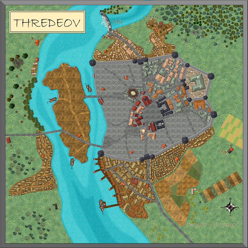
Here is the continuation for my city of Thredeov on my own world of Myirandios, but also will be the Dunorian town of Vertshusen on the continent of Ezrute in the Community Atlas. Now I have finished Khelaphet, I thought I would start a new thread dedicated just to Thredeov/Vertshusen.
Remy Monsen has just told me that Vertshus means 'Inn' in Norwegian, so I guess its beginnings will be from a famous Inn now incorporated into the city - alert to all ye Inn mappers.
Remy Monsen has just told me that Vertshus means 'Inn' in Norwegian, so I guess its beginnings will be from a famous Inn now incorporated into the city - alert to all ye Inn mappers.
Comments
it has 1297 buildings, so i thought a total population of about 5,500 - what do you all think? is an average of 4 per building in a latish medieval setting too much or too little?
The building index is yet to be done, plus a few more specialty buildings eg 2 cheese factories, 1 more timber mill, and a small ship repir/supply and perhaps 1 shipbuilder for the smaller vessels.
What should I do with the sewerage? I have a bit of obsession about this, I guess because I am a (retired) medico. An underground sewer, sewer drains down the middle or sides of streets with nightsoil collectors or any other system. Sewer outlets of course can be anywhere downstream - environmental pollution is such fun (ask my hero, Donny Dump).
Also, what about water supply - do I need overland pipes from the weir, or will underground pipes (lead, of course) be reasonable (as happened with many Roman cities who used both tunnels and aqueducts - and of course, lead pipes).
Finally, anything else I need to address. All comments are very welcome, as I am beginning to warm to the idea of creating more cities - laborious, but lots of fun - and all ideas are going to be very helpful for the future projects.
I hope to finish this in the next few days if I feel well enough (I am in hospital at present), then onto the completion of Fahrwasser, a city of 20,000 - 30,000.
1: the bigger vessels dock south of the bridges; the smaller upriver ones dock at the piers north of the bridges - only these smaller, more shallow bottomed vessels can make it further upstream.
2: the bridges can be raised up by chains attached to the tower apparatus at each end - just like a major bridge in Sydney, my hometown, had too about 1966 - and an up to 2 hour wait till the bloody boats went past, and the bridge was lowered again. I have shown where it parts in the middle, but not where the 'hinge is - guess just enough to allow the various vessels (the small upriver craft who might want to venture downstream) through.
I think the tinier details like drainage and sewerage (which may be combined in more primitive cities), are more at the dungeon map scale of things?
I can't imagine how much this is bogging your machine's memory down already!
(I am sure Remy Monsen will understand all this gibberish).
It cost me ~ 600 EU ($A1200) 8 months ago.
With all effects on, and every sheet on, the refresh time is about 5-10 seconds.
Hope that helps - I am really a computer ignoramus.
No wonder I couldn't open the map! LOL!
Which is just as well when it comes to Fahrwasser with over 5500 buildings now. And a slower refresh time, unless I turn off various layers/shhets and effects - then about 5-10 second refresh time.
River flows from top to bottom of map??
Since this is a walled city, I assume that there is danger of attack from some invader. Overland pipes would be a major weak spot in those defenses so underground piping would probably be better (and easier to map!!) Unless this is a very wealthy town, I would think that the cost of lead piping with a big enough diameter to supply the city would be prohibitive. So some sort of underground tunnel might be better. with cut stones forming the bottom and sides of it with large stone slabs spanning the side walls to cover the channel with a thick layer of dirt overhead.
The weir, depending on it's height might not be a hindrance to barge traffic. I seem to remember that in the Germanies of the 16th - 17th century when every landholder would throw weirs across the rivers to harness the power of the river, there would be a lowered section in the middle that allowed free flow of water over the weir. This would be wide enough to allow barge traffic to be hauled up over or to travel down the river. The weir o0wner would of course charge tolls to anyone wanting to traverse the weir.
I will definitely use the underwatr tunnel system, for both water supply and sewer drainage of liquid waste and rain, fed by open-water drains for the most part, with the good ol' nightsoil collectore (let's call them the Poomen).
And what you have written is just the sort of ideas I want, though these we may later discuss (disagree, violently argue, go to war about, do a Trump!).
As for water, with a river running right next to it, I am guessing it will be a lot of ground water in the area too, meaning that most of the water in the city will be from wells feeding from the ground water, no pipes or fancy water system needed.
The river doesn't look like the right placement according to the Dunor map, but that can easily be explained by details not being shown on a large-scale map. Anyone considering mapping a regional map of that area should take that into consideration though.
My next effort will be to map the capital of my own world's empire, a city right on the equator (think Singapore), sort of Steampunk, only with clockwork and use of electromagnetic energy directly from the brain of adepts - called etherics (instead of magic), with printing press, horseless clockwork carriages and blimp-type air clockwork/etheric/gas machines; and where the dominant social group are black women - who treat white men just as 1960's treated black women in USA and australia. The reversal of roles leads to some unpleasant self realizations, i must say. The population of the city of Jhelrosis is 1 million - like ancient Roma and Constantinopolis. (-rosis suffix is equivalent to -polis in Constaninopolis).
And i promise a Maze in (Amazin') that city!
I much preferred the previous colour scheme.
EDIT: Ah, I see now - I commented before you uploaded the main map, so all I could see was the sewer version! LOL!
Looks really great! Congratulations on finishing it
really awesome!