

WIP The Barrow Hills

Hi all,
I am fairly new to Campaign Cartographer and have been working on a map for a D&D campaign that I am planning. I still have a lot of work to do -- including coming up with names for a lot of the regions and some of the historical people, locations, and civilizations. For the most part, I've been spending my time learning about geography, cities, mountains, the flow of rivers. Fun stuff. Pretty sure that my wife is sick of me talking about all of this. ;) :P
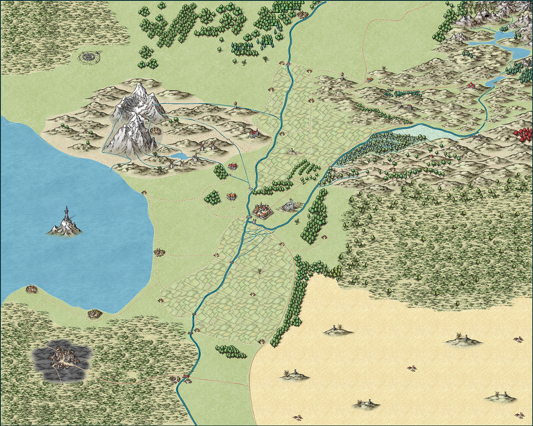
Anyway, here's the map I am working on... The region is called the Barrow Hills. Most people won't know why it has that name -- they couldn't point to any specific burial grounds, but there are burial grounds from one of the first civilizations to have settled the region in the hills just south of the east-west river. (One of the initial plot hooks I am planning.)
[Image_11224]
Culturally, this is a Mediterranean-style civilization -- a melting pot of different cultures and races. The town and villages are filled with humans, dwarves, and elves. The grasslands belong to aboriginal tribes who reclaimed the land of their ancestors soon after the cataclysm.
Historically, this region was the center of several civilizations -- mostly because it was a powerful nexus of magic. 200 years ago, there was a great explosion in the capital city and a blight settled over the city and the surrounding region. Since then, major magics (anything above a cantrip) has not worked consistently -- so much so that they have been banned. However, cantrip-level magic has become a pretty significant part of the culture here and is contributed significantly to the development of the region: from farming to herding to mining. While the region is no longer a significant magical or military power, it remains an economic powerhouse (relative to its size).
Also, there is quite a bit of scrubland on the map -- this is due to de-forestation over the years. This region used to be a lush forest, but over the years, the forests have been cut down. The scrublands are prone to fires during the occasional dry summer.
I am still working on a government -- leaning toward a Council of 3-5 Barons. Their mansions can be seen to the west of the river and to the east of the mountains
Weather... I am thinking something similar to the wine region of Italy. Somewhat humid -- can get hot in the summers, but bearable. I would really like the hills just south of the east-west river to have the weather and soil to produce some really great wine.
Anyway, there's a lot more that I have planned -- and still need to finish the map, but thoughts and ideas are certainly welcome!
My specific concerns...
1) This being my first map, I am still sorting out the scale. I would like this region to be around 500 square miles ... but I am not sure if I have packed too much into what is supposed to be a regional map.
2) Is it plausible for two lone mountains to exist where I have them? (The mountain in the middle of the lake was magically created by a wizard for his tower. No one has been out to the tower in ages.)
3) I have a swamp sitting between the east-west river and the hills. There's also a marshland next to the swamp. Not sure how plausible this terrain in this location is.
I am fairly new to Campaign Cartographer and have been working on a map for a D&D campaign that I am planning. I still have a lot of work to do -- including coming up with names for a lot of the regions and some of the historical people, locations, and civilizations. For the most part, I've been spending my time learning about geography, cities, mountains, the flow of rivers. Fun stuff. Pretty sure that my wife is sick of me talking about all of this. ;) :P
Anyway, here's the map I am working on... The region is called the Barrow Hills. Most people won't know why it has that name -- they couldn't point to any specific burial grounds, but there are burial grounds from one of the first civilizations to have settled the region in the hills just south of the east-west river. (One of the initial plot hooks I am planning.)
[Image_11224]
Culturally, this is a Mediterranean-style civilization -- a melting pot of different cultures and races. The town and villages are filled with humans, dwarves, and elves. The grasslands belong to aboriginal tribes who reclaimed the land of their ancestors soon after the cataclysm.
Historically, this region was the center of several civilizations -- mostly because it was a powerful nexus of magic. 200 years ago, there was a great explosion in the capital city and a blight settled over the city and the surrounding region. Since then, major magics (anything above a cantrip) has not worked consistently -- so much so that they have been banned. However, cantrip-level magic has become a pretty significant part of the culture here and is contributed significantly to the development of the region: from farming to herding to mining. While the region is no longer a significant magical or military power, it remains an economic powerhouse (relative to its size).
Also, there is quite a bit of scrubland on the map -- this is due to de-forestation over the years. This region used to be a lush forest, but over the years, the forests have been cut down. The scrublands are prone to fires during the occasional dry summer.
I am still working on a government -- leaning toward a Council of 3-5 Barons. Their mansions can be seen to the west of the river and to the east of the mountains
Weather... I am thinking something similar to the wine region of Italy. Somewhat humid -- can get hot in the summers, but bearable. I would really like the hills just south of the east-west river to have the weather and soil to produce some really great wine.
Anyway, there's a lot more that I have planned -- and still need to finish the map, but thoughts and ideas are certainly welcome!
My specific concerns...
1) This being my first map, I am still sorting out the scale. I would like this region to be around 500 square miles ... but I am not sure if I have packed too much into what is supposed to be a regional map.
2) Is it plausible for two lone mountains to exist where I have them? (The mountain in the middle of the lake was magically created by a wizard for his tower. No one has been out to the tower in ages.)
3) I have a swamp sitting between the east-west river and the hills. There's also a marshland next to the swamp. Not sure how plausible this terrain in this location is.
Comments
If that's your first CC3 map its a great map.
You seem to have everything really well planned out.
If you are having trouble with making up names for things, there are lots of online random name generators you can use. Some of the better known ones are the Donjon ones
There are lots of different generators on the donjon page, but this one provides town names, as well as a bit of possible information
https://donjon.bin.sh/fantasy/random/#type=town
Your scale seems fine to me. Your swamp and marsh are good where they are and the singular mountains add a flair that works for any fantasy campaign.
Thanks for sharing. I hope to see more as you progress with the map.
As for scale: Since you're making this map for a D&D campaign (Fantasy Setting) it's best to reason from that direction. You mention 500 square miles which would mean that the map has dimensions of 25 x 20 miles (if I got the ratio of your map correct). At this point it's important (for your campaign in which you want to use the map) that you think about what you want to distance between various cities, villages and other terrain features to be. Think about how long you would expect your players to travel between different points on your map and base your scale on that. Personally I think 25 x 20 miles is on the small side, but it's your campaign and it needs to make sense in your world.
The swamp and the mountains work fine in a fantasy campaign and you have already given a possible explanation (if there is need for one) in your own description: "mostly because it was a powerful nexus of magic...Since then, major magics (anything above a cantrip) has not worked consistently" I would say this could easily affect the world as well.
You seem to be building your campaign with a strong sense of history and purpose, which is great, so let that guide your mapping. In the end you want the map to enhance your campaign so keep that in the back of your mind, but don't let it control your creative process. In my own campaigns I sometimes change the world because of something I do in my mapping and sometimes I change a map to accommodate my campaign ideas.
I have been playing around with CC since March, learning the ins-and-outs and mostly following tutorials on how to use it, looking at people's maps that I like, as well as reading more about the craft of mapmaking and worldbuilding. I am pretty happy with the results so far, but I am a total noob, so hearing your more experienced opinions means a lot.
Thank you Shessar and JimP for the encouragement. Means a lot coming from you two.
Thanks, Loopysue, for the pointer to donjon. I'll definitely be using that when it comes time to name everything.
And, Silverdrop, lots to process...
I love the idea that there is so much history around us -- that we don't need to travel the world to find interesting things. My plan is to start the campaign in a small area, focused on a few local problems--that being said, given the history of this region, these "local" issues will have a pretty huge worldwide impact. I am mainly focusing on the smaller region to hone both my mapmaking skills and my storytelling skills -- start small, build from there. I am using the size of the county from my childhood as a reference, which is a bit more irregularly shaped than this, but is approximately 25 x 20 miles.
It's certainly been interesting to consider how geography + weather and magic might coincide. Ideally, I would like the magical events to happen and then the geography and weather patterns to continue -- either trying to repair the change or adapting to the change in landscape/weather.
And I completely agree, there is a symbiotic relationship between the story I want to tell, the history of the place, and the geography+weather. I also think that once the players are introduced to this place, they will pretty heavily shape things, too.
Thanks, again, for all the encouragement. I'll post an update here in a week or so.
And definitely appreciate the encouragement. :) Hoping to get an update posted in the next few weeks accounting for all this great feedback.
Thanks for the feedback!
A side note for Texas, if you see FM number, on a road sign, that means Farm to Market. It was a road built to conect farmers to the nearest town. It may not reach town, but connect to a county or state road, which does reach the nearest town.
I've re-positioned many of the homesteads and increased the amount of farmland.
I wasn't happy with the northwest portion of the map, so completely re-made that.
I re-worked the southwest portion of the map a bit.
And I cleaned up a range of other oddities.
Stylistically speaking, there's still a bit to do with the map, but overall, I think it's coming together.
Thoughts?
I only have just the one thought, and that is the hardness of the lines between extremes of terrain - the way the desert (is that a desert fill?) butts up to the trees and the swamp in the south east quarter of the map. Maybe an Edge Fade Inner sheet effect on that sheet (or a bigger one if you already have one there) would help to ease the lush vegetation into the grass-coloured land, and then to desert/plain?
Having added the EFI to the desert/plain, you could do the same with the mountain background, so that there are no more hard lines in the terrain?
In most cases (and unless there is a cliff or a mountain ridge) the transition between ecologies is relatively gradual.
If you click the sheets and effects button (that one on the left with the three yellow sheets on it) do you have the 'Activate Sheet Effects' option ticked at the top of that dialogue?
The reason I ask is that I'm almost certain I can't see any of the usual sheet effects in your map, and it may well be that you haven't gotten around to considering them as part of your CC3 tool set
You're right: I don't have the sheet effects turned on. I've put some of the symbols and backgrounds on custom sheets that don't have effects on them. Like the farmland, for example, I have it on a custom sheet so that it sits under the rivers and over the scrubland (which is actually a symbol and not a background). I also don't like some of the default sheet effects -- for example, the farmland has too thick a blur on the edges.
Sheet effects is definitely one of the next things I will be working on.
The desert fill is actually a grassland/plain fill. It does look a lot like a desert, but not sure what else to do there. I might look at some of the other styles to see what they are using for grassland.
Also, do you know how to turn off the outlines? I somehow turned on the paths -- those white lines running through the map -- and they have been great for editing, but I cannot find the setting to turn them back off. I need to set up a macro that turns those off before exporting a jpeg.
Thanks for the continued feedback. I'll post an update with the sheet effects in the coming days.
If you don't like some of the Sheet Effects you can untick them for that particular sheet in the Sheets and Effects dialogue. Or you can pick them and edit them until you do like them. I prefer to leave all the default effects in place but unticked, instead of deleting the effect (be careful you use the correct DELETE button if you do delete an effect - the one below it deletes the entire style)
EFI effects are editable too, so you can reduce the thickness of the fade if you want.
Lots of people mix and match different styles. That's one of the beauties of working with CC3. You can mix and match. It can be difficult, however, to find a harmonious match when mixing styles. You might be better off adding a few more details to the large open areas, like roads or ruins or some such.
Sheet effects are an amazing thing that when mastered can turn a good looking map into an amazing one when done right. So experiment with them.
When working with the effects, another handy thing is that you can copy and paste effects from one sheet to another. So if you have fine tuned an effect for one sheet and you want to have the same exact effect on a different one, just copy it from one sheet and paste it in the other. And you can also use this when you're worried you'll mess up an effect by changing it. Just make a copy of the effect and past it right under the original, turn off the original and edit the copy. If you don't like it you can delete the copy and go back to the original.
And of course be aware of the order of the effects as one is applied after the other and the end result can be quite different with a difference in order.
I can't figure out why the mountain background doesn't have the EFI effect on it -- as far as I can tell, it is on the same sheet as the hill background and the farmland. Any suggestions?
Other than that, I think it might be time to start adding labels. Any other suggested improvements?
Thanks!
An EFI effect only works on the outside edge of the total area of the polygons on that sheet, so if you have a mountain background totally enclosed by a hill background on the same sheet the mountain background won't be faded.
To put this right you need to move the mountain background onto its own sheet and either copy the EFI across from the hill background sheet or add a new EFI.
If the hill background is on the same sheet as the farmland it must just be by sheer luck that those two fills aren't actually touching each other or overlapping anywhere. They are so close in some places that its more likely they are on separate sheets? Maybe, maybe not.
You can get more information about an object, including what sheet it is on, using the menu item Info/List and selecting the item(s) you want to know about, then clicking 'do it' - as with most of the other commands
Other than that - looking better than ever with a few nice sheet effects in play
That makes so much sense! I think I missed that explanation of sheets in all the tutorials I've watched. I actually spent a lot of time making sure that none of the background patterns touched -- so I did catch that if they were touching, the effect wouldn't apply. Haha.
Anyway, here's the updated version with the mountain background fixed.
Looking at the map more, I am not happy with the way the lakes look. I've seen better looking lakes here on the boards. I'll probably spend some time this weekend working on those before I start adding the labels.
Thanks for all the help!
What about the lakes don't you like?
As for what I don't like with the lakes -- they feel like something is missing. Maybe it is as Scott suggests -- I need to create darker areas toward the center to connote depth.
I'm being a big slow on this desert not being a desert!
Sorry!
You could put it on its own sheet and change the colour of it using a Hue Saturation Lightness Sheet Effect (HSL effect). You wouldn't have to spend ages looking for a similar fill then
I use them all the time to get different shades of grassland.
No worries! It definitely looks a lot like desert!
So, here is the latest. I found a Prairie texture that was closer to what I wanted, but it was more green than a grassland yellow -- and then used the HST to add some yellow to the texture. So, hopefully, the southeast looks more like steppe and the northwest and northeast corners look like forested steppe.
I am happier with the large lake, now -- though I don't feel like it is 100% there, yet. I am curious what folks think about the border of the lake against the northwest steppe.
And, apparently, at some point, I lost the wizard's mountain and tower in the middle of the lake. That is now back.
Anyway, thoughts and suggestions are always appreciated!
I don't think I have any other suggestions...
My personal opinion FWIW is that the mountains on the coat and the island would appear to be a continuation of the geological line - perhaps some minor island/islets/reef along that line, between island and coast, and maybe beyond the island. It might give opportunities for shipwrecks and whirlpools and such.
Just my thoughts is all
Thanks!