

Age of Angaara
 Dungeon Master Gaz
Traveler
Dungeon Master Gaz
Traveler
Hi Guys
Long time – no posts…
As usual, I’ve been lurking in the background, watching everyone’s submissions and posts, and tremendously enjoying what you guys are coming up with. But, as many of you will already know, life etc., just doesn’t give me the time to support the CC3 forums like I would like. I’m always here. I’m always watching, and you know CC3 is my one and only...
In January I presented my new campaign setting to my players: Age of Angaara. It’s a mesolithic campaign setting for D&D 5e. My players play members of the Taigaan tribe, a group of semi-nomadic hunter-gatherers in a fantasy setting gripped by an ice age. Their level of technology (both social and technological) puts them one step above the cavemen of the palaeolithic era, living in caves and producing stunning cave-art, and one step below societies of the neolithic era who have developed agriculture, animal husbandry and monolithic architecture.
My inspiration for the setting comes from films, books, documentaries and games such as 10,000 BC, Apocalypto, Professor Alice Robert’s Ice Age Giants, research on Gobekli Tepe, the video game Far Cry Primal, and just a fascination in the possibility that advanced human culture might have existed prior to the end of the last ice age – as opposed to When Dinosaurs Ruled The Earth or 1,000,000 years BC (so no dinosaurs in this setting! But there are dragons, haha)
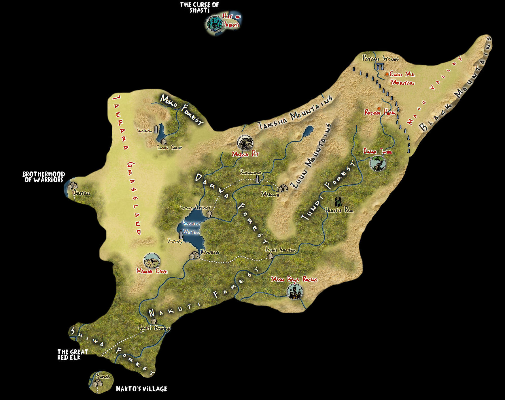
The map I’m posting today is a copy of the player’s map. I’ve used the 13th Age style as a base because I felt it produced a better topographic style than other styles, and with writing being non-existant in Angaara navigation is by sight, landmarks, and already explored areas. I felt this style served that purpose. I’ve also added symbols from the Ancient Realms Annual style to represent the landmarks, and symbols from the Overland Vector Colour style to represent physical, man-made, sites.
I have finished the entire map, but I would like to share it with you as I share it with my players.
My Age of Angaara Player’s Bible describes Angaara thus…
“Old Mother described Angaara to the Taigaan people. Her visions had shown her a verdant land, abundant in game, and providing all the resources the Taigaan would need to build a new life after the demon-men came.
In time, just as Old Mother had foretold, the Kagrah demon-men appeared and murdered all the Taigaan they found, driving them from their homes on the Plains of Embe. Those who escaped the initial attacks wandered for many days and nights, following the clues given in Old Mother’s visions. Many of them perished along the way, for the Kagrah were relentless in their extermination of the Taigaan – but a few survived and made it to the promised-land.
Angaara proved true to Old Mother’s visions. Great forests provided a home to boar, deer, elk, sloth, and goat. Buffalo, antelope and mastodon wandered the grasslands. Healing plants grew along the banks of streams and rivers of fresh, clear water. Mighty conifers with trunks of strong wood towered over the landscape, and birds of all kinds populated the skies. Truly – if there ever was a land created for the Taigaan then Angaara was it...”
Enjoy the Adventure…
Long time – no posts…
As usual, I’ve been lurking in the background, watching everyone’s submissions and posts, and tremendously enjoying what you guys are coming up with. But, as many of you will already know, life etc., just doesn’t give me the time to support the CC3 forums like I would like. I’m always here. I’m always watching, and you know CC3 is my one and only...
In January I presented my new campaign setting to my players: Age of Angaara. It’s a mesolithic campaign setting for D&D 5e. My players play members of the Taigaan tribe, a group of semi-nomadic hunter-gatherers in a fantasy setting gripped by an ice age. Their level of technology (both social and technological) puts them one step above the cavemen of the palaeolithic era, living in caves and producing stunning cave-art, and one step below societies of the neolithic era who have developed agriculture, animal husbandry and monolithic architecture.
My inspiration for the setting comes from films, books, documentaries and games such as 10,000 BC, Apocalypto, Professor Alice Robert’s Ice Age Giants, research on Gobekli Tepe, the video game Far Cry Primal, and just a fascination in the possibility that advanced human culture might have existed prior to the end of the last ice age – as opposed to When Dinosaurs Ruled The Earth or 1,000,000 years BC (so no dinosaurs in this setting! But there are dragons, haha)
The map I’m posting today is a copy of the player’s map. I’ve used the 13th Age style as a base because I felt it produced a better topographic style than other styles, and with writing being non-existant in Angaara navigation is by sight, landmarks, and already explored areas. I felt this style served that purpose. I’ve also added symbols from the Ancient Realms Annual style to represent the landmarks, and symbols from the Overland Vector Colour style to represent physical, man-made, sites.
I have finished the entire map, but I would like to share it with you as I share it with my players.
My Age of Angaara Player’s Bible describes Angaara thus…
“Old Mother described Angaara to the Taigaan people. Her visions had shown her a verdant land, abundant in game, and providing all the resources the Taigaan would need to build a new life after the demon-men came.
In time, just as Old Mother had foretold, the Kagrah demon-men appeared and murdered all the Taigaan they found, driving them from their homes on the Plains of Embe. Those who escaped the initial attacks wandered for many days and nights, following the clues given in Old Mother’s visions. Many of them perished along the way, for the Kagrah were relentless in their extermination of the Taigaan – but a few survived and made it to the promised-land.
Angaara proved true to Old Mother’s visions. Great forests provided a home to boar, deer, elk, sloth, and goat. Buffalo, antelope and mastodon wandered the grasslands. Healing plants grew along the banks of streams and rivers of fresh, clear water. Mighty conifers with trunks of strong wood towered over the landscape, and birds of all kinds populated the skies. Truly – if there ever was a land created for the Taigaan then Angaara was it...”
Enjoy the Adventure…
Comments
Interesting concept for a game world.
Exported from CC3+ as a .png. Re-sized to 1024 x 819, 613kb in Gimp. Shows on my Surface Pro 4 no probs, but doesn't upload?
DMG
Tried IE4 as opposed to Edge, and seems to have worked
DMG
Thanks LadieStorm. The "fog of war" idea has been accepted really well with my players. Normally my campaign settings are in traditional sword & sorcery settings, so the flow of information from army's, merchants, diplomats, explorers, or other adventurers means large portions of the map are already "discovered" (unless its some kind of lost world or terra incognito). But in this setting, with a lack of written language and the only art being cave paintings, I wanted to invoke a sense of discovery in my players and only reveal what they can see or visit.
DMG
It is just a section. The whole map is 5000 x 4000. This is just a crop of the central part.
Angaara began about 3 years ago. We were playing 4e D&D at the time. I was getting tired of the fantasy setting and wanted to throw my players a curve ball, so I had a violent trans-dimensional storm shipwrecked them on the shores of Angaara.
Back then, this is what it looked like...
DMG
Its the colours and the tribal flavour that do it for me
Glad you like the maps, whichever you prefer.
As I mentioned, I went with the 13th Age style for the new map because it seemed the only style that simulated a natural topography. With the absence of any form of writing amongst the Taigaan (the people that my players characters belong to) I didn't feel I could justify an over-abundance of symbols. I did consider using the Vector Colour style again when I set out to recreate the Angaara map, and imagined the symbols might evoke the feeling of cave paintings, but it just couldn't get it right when I put it together.
Never had any difficulty with the 13th Age style though. I find it really quick to use, and you can get some cracking results. I even started to convert my Aethir setting map into 13th Age. Here's a section I exported from it...
DMG
I'm not all that fond of the vector maps, so this second one is my favorite... but that is just my preference, of course.
... and you're absolutely right, Lorelei. It's pure 13th Age drawtools and symbols. No Dungeon Mastery involved!
The only thing that's not out-of-the-box 13th Age is the desert bitmap fill. I wasn't happy with the shade of the desert fills that came with the style so I copied the files, made them lighter in Gimp, and reinserted them in CC3+.
Another example...
DMG
Quick tip: to lighten or darken fills you don't have to go through the trouble of taking them into GIMP. Just use the Adjust Hue/Saturation effect. Since discovering it, I've used it to great effect on loads of things.