

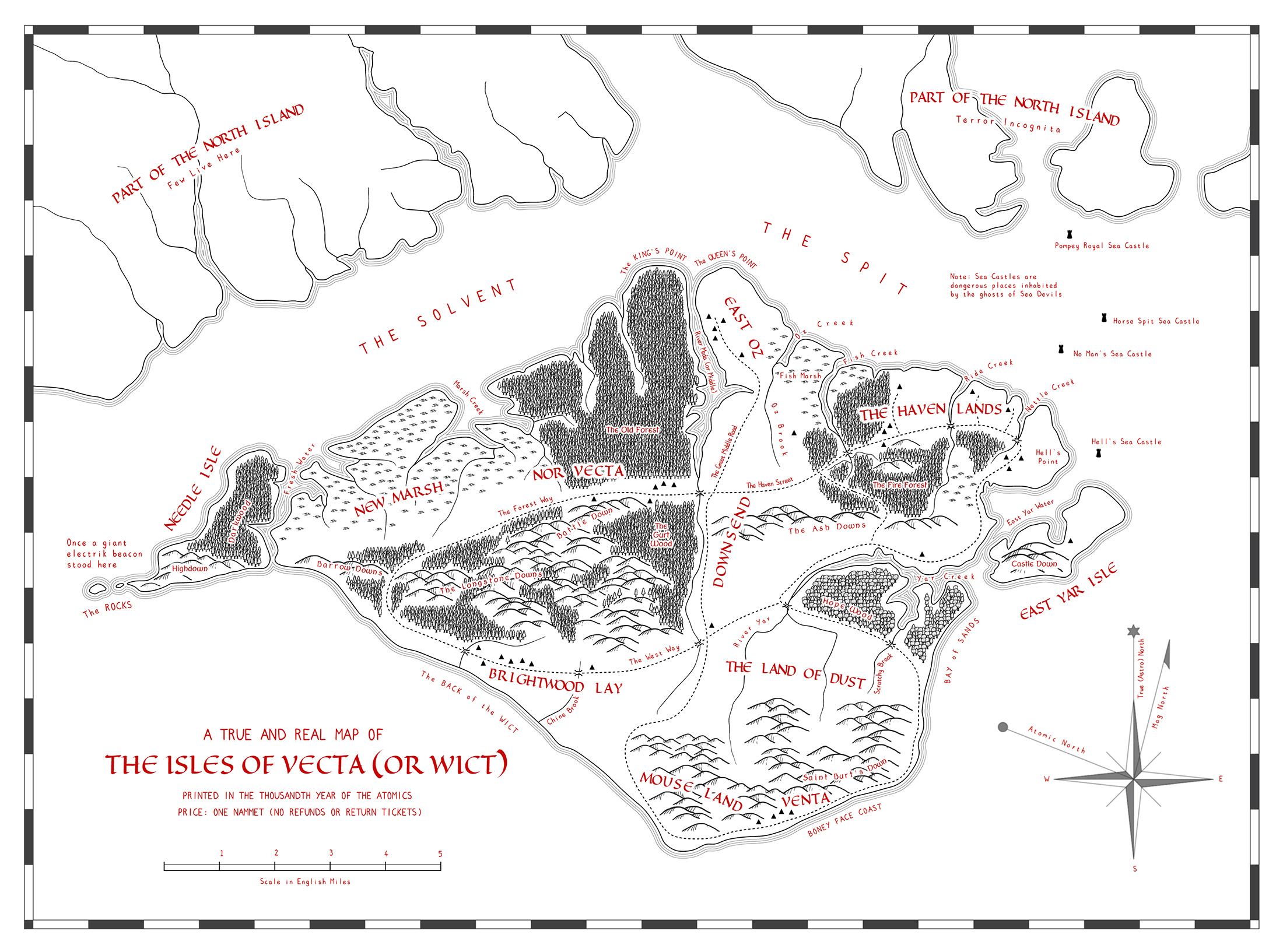
The Isles of Vecta or Wict
 PeteF
Traveler
PeteF
Traveler
A high resolution version of this map is available here This links to my DeviantArt page. The original can be viewed and/or downloaded from this page.
Background
On 26th September 1983 the Soviet Union early warning system falsely detected the launch of multiple intercontinental ballistic missiles from bases in the United States. The Soviets immediately retaliated to what they thought was a US first strike nuclear attack. Within 12 hours over 60,000 thermonuclear weapons had been detonated destroying all of the world’s population centres. Within a year only a few thousand humans remained.
Many years of drastic global cooling and warming cycles followed. Sea levels rose then fell. Over the centuries traces of pre-war human structures, science and culture almost disappeared. However the few human survivors gradually began to establish small communities, mostly on isolated Islands. Primitive civilisation started to re-emerge and a thousand years after the war a map of one of these Islands was printed.
Comments
Lovely map, Pete
Great back story too
I hope to make a few more maps concerning this alternative timeline. I usually like to base my maps on real places - this one was based on a hand drawn map I made in the early 1980's that I recently discovered rolled into an old poster tube. It has given me the incentive to get into CC.
I love the time-distorted names.
The map is very clean and I like your use of fonts, particularly the snippets of information offered, and the compass rose is uniquely cool.
Just one question - what do the little triangles represent? Did I miss something?
Superb job!
DMG
No you didn't miss anything. It was me being lazy by not putting on a legend.
The triangles represent houses or small groups of houses e.g. a farm, small hamlet etc. By this time buildings were either stone (often recycled) or wattle and daub. Roughly equivalent to the early to mid medieval period that we know.
The map is entirely made in CC with the exception of the compass rose which was made in Inkscape and imported as a bitmap and the marsh symbols which I made externally and imported in as a symbol set.
I was pleased with the fonts. This is one of the reasons that I persist with CC. I think that it's typology can provide an interesting hand drawn effect. Modern vector apps are too good at kerning etc the text on curves and it all looks a little sanitised.
Is this just a mapping project for fun, or does Wict belong to an RPG campaign or other story? I think it's complete with just the map and back-story, but was wondering if it's part of something larger?
DMG
There is no RPG campaign involved (but that doesn't mean that someone else couldn't pick it up and make one). This is just done as a piece of map art with a backstory that kind of evolved with the map. It is the first project completed with CC3+ and helped me understand the application to a basic level. My next project is in the same alternative timeline and is aimed at progressing my knowledge a little more.
Pete