

Washed out symbols on map
 GThiel
Surveyor
GThiel
Surveyor
I've noticed an odd behavior in CC3+. On a map on which I'm working, I've noticed that certain symbols on the map appearing "washed out." (see First image) But I've I change zoom level, then they appear as they should. (see pic 2), but if I change zoom level again, they once more appear washed out. When I export the image as a jpg or png they appear to be washed out. They are on the same sheet as the other symbols in the image and there is no transparency set for that sheet. 'Tis a puzzlement! Any suggestions??
Jerry
Jerry
Comments
Are there any other effects on that sheet - I mean apart from the fact that you have already stated there's no transparency effect?
Sue
The reason for the behavior in different export resolutions are the same. At 2500 export, the symbol is so small that the low res version is used, but at 5000 the high res is used.
A workaround for this is to click the display speed settings button (the hourglass) in the left toolbar, and set the quality to 'Fixed' and 'Very High', and then clear the memory cache. This will cause CC3+ to only use the high resolution version of everything.
Also, a hint about your scale. It is always advisable to create the drawing in the proper scale when you make it, since it makes for a much easier mapping experience, since everything will be scaled correctly out of the box, and you can use CC3's measuring tools to find distances. I notice that when I measured the scale bar in your map which claims to be 40 feet, but is in reality 80, which means you work at an artificial mapping scale of twice the natural scale. Remember, the size of your map when you make it should always represent the real world scale (as opposed to paper/print/export scale) of the things you are mapping. So if you create a map for a room that is supposed to be 15 by 20 feet, make sure to make the map 15 by 20 and so on.
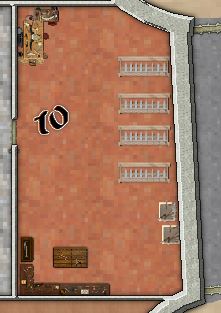
Re: scale. There are things I am not fond of in CC3+ because of their non-intuitive nature and lack of on screen explanations. Scale and Grid size are in this class. Built new base map and set up new scale/grid and copy and pasted my original map onto it. and using the distance tool, things seem to be matching up now. When I originally drew the map, I was going off a pic of an actual castle and was winging it as I added things, so had created a base map that I thought would be big enough to fit it into. I was not too worried about scale, just wanted enough real estate to fit everything in. Here's an image of the map after creating a new base and copying and pasting the old items onto it. Still a few touch ups to do on the map after copy. By the way, the washed out image stayed that way after the copy and paste until I changed the quality to fixed and very high. (well I was going to attach a pic of the citadel, but when I tried to add it, I get the following message)
As for scale, it isn't that un-intuitive really, if you just always think about the scale numbers as real-word units, which is one of the core concepts of CC. A castle wall is 5 feet thick, it isn't 1 inch (paper scale) or 25 pixles (exported image). When you make a map, you express the size in real world units (feet for dungeon/city maps, miles for overland maps [or meters/km for metric maps]), and everything you do in the map is based on that scale. For example, need a 50-mile grid on the overland map; then set the grid spacing to 50. If the distance tool in a dungeon maps says something is of length 50, then that is 50 miles.
Internally, everything is represented in a generic unit called map units, which are again defined to match whatever unit the map is in (miles, feet, light years, parsecs, etc..)
As for the image upload, perhaps your image was too large? The forum refuses images over 2MB in size (but the error message from the software isn't particularly helpful)