

Community Atlas - Quake Island
 Monsen
Administrator 🖼️ 82 images Cartographer
Monsen
Administrator 🖼️ 82 images Cartographer
So, I wanted to create a special map to celebrate the 1-year anniversary for the Community Atlas.
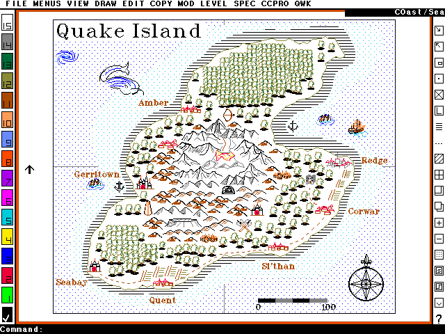
So, I decided to make a map using CC-DOS (With CC-Pro 1.2). My first challenge was getting the coastline exported from a modern CC3+ map and onto an old CC-DOS map (.FCD file). CC-DOS claims to be able to import .dxf files, but after exporting the coastline in .dxf format from CC3+, the result after importing to CC-DOS was anything but correct. In the end, I ended up creating a script file by copying the coordinates from the list window in CC3+ and doing a couple of search/replace tricks to generate a script file that would draw a polygon using the same coordinates when run under CC-DOS. Unfortunately, I also ran into a limit in CC-DOS, it seems a polygon can only have 126 nodes. So I had to use Joe's great new SIMPLIFY command on the coastline first followed by a few manual node deletions to bring it down to 126 before I could proceed.
I initially also tried just typing in about 30 nodes manually, and then fractalizing the landmass, but I learned that CC-DOS fractalization turns the polygon into lots of individual lines, with no easy way to join them back together. The fractalized landmass looked quite good until I realized this, but with individual lines instead of a polygon, I didn't have any way to fill it, so that attempt didn't work out well.
After importing the landmass, mapping in CC-DOS isn't that different from CC3+. It is certainly MUCH more clunky, and it is severely lacking in toolbars, so I am glad I already knew the text equivalent of most commands before going ahead. Of course, it also lacks a LOT of the tools and commands I am used to. I was a bit frustrated from the lack of a send to back command, it only had a send to front command (as far as I could figure), which technically allowed me to do the same, just with a bit more work. And forget sheets and drawing tools and effects.
An interesting thing about CC-DOS is that the symbols aren't really symbols, they are just grouped entities. For practical purposes, they behave the same however. Another issue with the symbols is that they all had transparent background, so I had to be very careful about symbol overlapping, or it would look really messy.
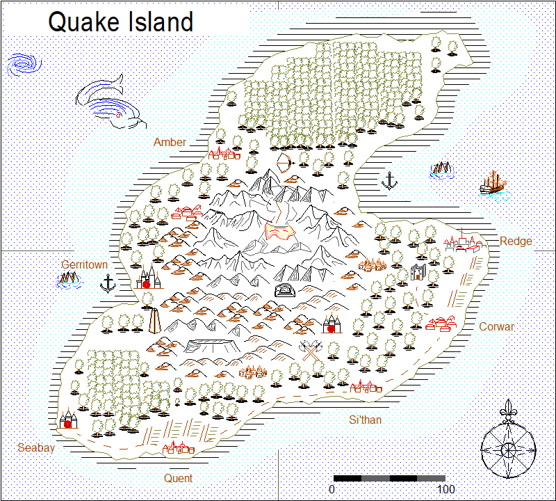
Finally, importing the map back into CC3+ also gave me some challenges. First of all, not all fill styles translate to the same fill style in CC3+, so I had to change a few fill styles. Also, CC-Dos allowed me to specify if I wanted outline individually on each entity, but in CC3+, that is defined on the fill level, so many entities ended up with an outline that shouldn't be there. Symbols also look "hollower" in CC3+, this is due to to the increased screen resolution and the use of 0-width lines. The low resolution of running in MS-DOS made simple line pattern fill looks more solid. The final issue is fonts. CC3+ does not handle those old fonts used by CC-DOS correctly, so all fonts use a plain Arial font instead when displayed. After changing the fill styles, the map do look mostly like it looked in CC-DOS however, if not 100%.
Note that brush pattern fill styles are not scaled, so if you look at for example the shallow water lines around the island, they stay the same size as you zoom in, which means that there will be many more of them. The distance (measured on screen) between each line will stay exactly the same, but this means that the distance (measured in map) becomes smaller as you zoom in.
Atlas Entry
[Image_10182][Image_10164][Image_10165]
So, I decided to make a map using CC-DOS (With CC-Pro 1.2). My first challenge was getting the coastline exported from a modern CC3+ map and onto an old CC-DOS map (.FCD file). CC-DOS claims to be able to import .dxf files, but after exporting the coastline in .dxf format from CC3+, the result after importing to CC-DOS was anything but correct. In the end, I ended up creating a script file by copying the coordinates from the list window in CC3+ and doing a couple of search/replace tricks to generate a script file that would draw a polygon using the same coordinates when run under CC-DOS. Unfortunately, I also ran into a limit in CC-DOS, it seems a polygon can only have 126 nodes. So I had to use Joe's great new SIMPLIFY command on the coastline first followed by a few manual node deletions to bring it down to 126 before I could proceed.
I initially also tried just typing in about 30 nodes manually, and then fractalizing the landmass, but I learned that CC-DOS fractalization turns the polygon into lots of individual lines, with no easy way to join them back together. The fractalized landmass looked quite good until I realized this, but with individual lines instead of a polygon, I didn't have any way to fill it, so that attempt didn't work out well.
After importing the landmass, mapping in CC-DOS isn't that different from CC3+. It is certainly MUCH more clunky, and it is severely lacking in toolbars, so I am glad I already knew the text equivalent of most commands before going ahead. Of course, it also lacks a LOT of the tools and commands I am used to. I was a bit frustrated from the lack of a send to back command, it only had a send to front command (as far as I could figure), which technically allowed me to do the same, just with a bit more work. And forget sheets and drawing tools and effects.
An interesting thing about CC-DOS is that the symbols aren't really symbols, they are just grouped entities. For practical purposes, they behave the same however. Another issue with the symbols is that they all had transparent background, so I had to be very careful about symbol overlapping, or it would look really messy.
Finally, importing the map back into CC3+ also gave me some challenges. First of all, not all fill styles translate to the same fill style in CC3+, so I had to change a few fill styles. Also, CC-Dos allowed me to specify if I wanted outline individually on each entity, but in CC3+, that is defined on the fill level, so many entities ended up with an outline that shouldn't be there. Symbols also look "hollower" in CC3+, this is due to to the increased screen resolution and the use of 0-width lines. The low resolution of running in MS-DOS made simple line pattern fill looks more solid. The final issue is fonts. CC3+ does not handle those old fonts used by CC-DOS correctly, so all fonts use a plain Arial font instead when displayed. After changing the fill styles, the map do look mostly like it looked in CC-DOS however, if not 100%.
Note that brush pattern fill styles are not scaled, so if you look at for example the shallow water lines around the island, they stay the same size as you zoom in, which means that there will be many more of them. The distance (measured on screen) between each line will stay exactly the same, but this means that the distance (measured in map) becomes smaller as you zoom in.
Atlas Entry
[Image_10182][Image_10164][Image_10165]
Comments
I prefer the CC3+ conversion
Sorry, Remy!
Doing this CC-DOS map was way fun though, I met quite a few hurdles in my attempt to get the actual landmass from the CC3+ map and to the CC-DOS map. But CC-DOS is surprisingly nice to work with, taking into account that it is a DOS program after all. Wish I had owned it back in the day, I still remember all this exciting ads in Dragon magazine when I was still a youth with an empty wallet. Never thought I would end up doing work for that very same company (and product)
Nothing quick about the maps though, especially as long as you do them in CC-DOS.
I think you can still make nice maps based on those symbols. I intentionally used CC-DOS itself to make this map, with all the limitations that included (including my limited familiarity with it), but if you combine these symbols with the modern feature of CC3+, I think the result can be nice.
I'll heartily agree with that. While I am still fond of those old symbols, I am also very fond of all the beautiful symbols and fills we have today in modern CC3+. And being far from artistic myself, I need those artists to create the pretty symbols for me, so I can compose maps from them.
Simon, you were enough of an artist to excite us older gamers with awesome mapping software. I didn't own a computer during the CC-DOS days but CC2v5 was the first software my husband bought me as a birthday gift and it was the envy of the other DMs in our gaming group. I used the line symbols almost as often as I used the colored symbols. Good stuff!
Monsen, Thanks for taking the time to do this map. It made my day.
I tweaked the brush pattern fills in the CC3+ version to make it look much more like the CC-DOS original, and updated the image in the first post. I had completely forgotten that the brush patterns were editable. I think this made the final map much better, the sea fills were a bit overpowering before when compared with the CC-DOS original, but now they look much more like it.
You and me both.
No, don't remove them! Their simplicity is ideal in some instances. I use them occasionally to represent maps drawn by an ancient silver dragon that sometimes offers guidance to the PCs. I need these symbols!