

My first map - recommendations welcome

Hello everybody,
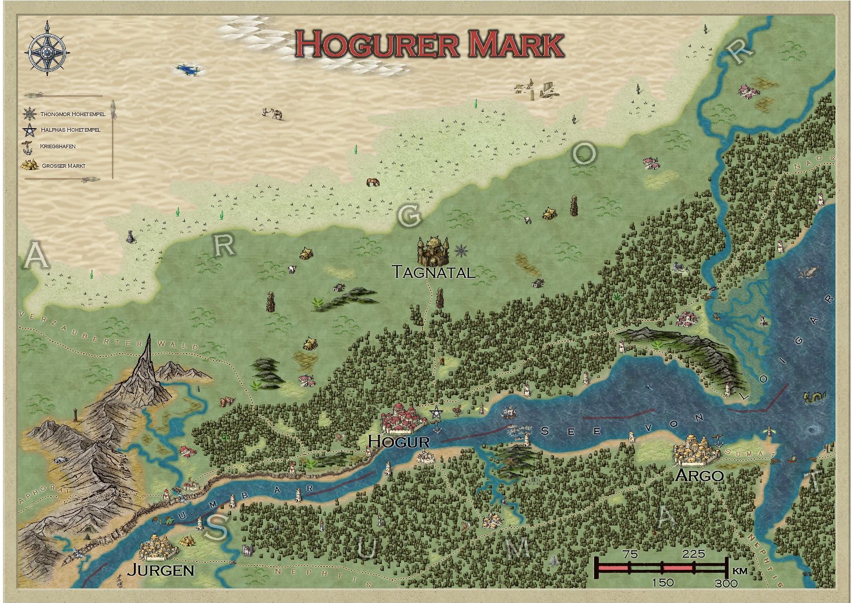
I am new to CC3+ and to this forum and I want to learn how to make my maps better. As I now finished my first map, I would like get some feedback from you to improve my skills. My first map is a regional map for a German indepent roleplaying game from the 90`s which is no longer supported (thats why i bought CC3+). So I used the original world-map for the basic layout (main river, mountains, forest, borders, desert etc) and then added details.
I have to admit that I was overwhelmed from the possibilities of the program and used symbols etc. from all different styles so that the map looks a bit eclectic. For future maps I learned my lesson and I will try to make them look more consistent (I maybe was too euphoric :-)).
I am not satisfied with the landmass, especially since I saw Hadrians Demosthenes Swamp I know that I need to learn a lot. So maybe you could give some advice how to improve.
Thanks in advance, Jensen
Comments
Give yourself a really big pat on the back for this. I'm not quite at your standard for overland maps - and this is your first CC3 map?! Fantastic.
And the mixing of styles seems great to me.
One question: I am unsure about the size of the different symbols. The camel in the desert is nearly as big as the town. How do you deal with the right scale of symbols?
Thanks you!
The most important scale-wise is to have the relative sizes of similar entities make sense. For example, a village should appear smaller than a city for example, but you can't really scale a camel and a mountain properly with regards to each other, that would make the latter unreadable small.
Great forum by the way. Very quick responses. Happy to be here.
This is a great first map. Congratulations, you did a great job on this one!
There is nothing in the map that needs to be criticized. But since you asked for recommendations, here are a few thing you could play with:
-If you wanted the dunes symbols to blend in a bit more with the desert background, you could put them on a separate sheet and add a light transparency effect. Please note that not all symbols react in the same way to this effect. Also, if you want the desert texture to be a bit more subtle, you could use copy to sheet (right click on the copy button) and copy the desert entity to a new sheet, which is lined up just above your current sheet (so it is covered by your current sheet). Hide the current sheet and use the modify tool to change the texture of this new entity to the Desert_MS fill style. Then you copy the edge fade effect from your current sheet to the new one (this way you make sure that both entities cover the same area) and add a transparency effect on the current sheet.
-Using a transparency effect (or a reduced inner opacity on an edge fade, inner effect) is in general a good way to make the map look a bit smoother. I can really recommend this with farmland fills (unless you use these fills to cover up something else), because one will still be able to see the individual fields but the texture blends in more nicely with the background.
-You made a very nice transition between the grassland and the desert by using a lighter grass texture for the borderlands. Don't hesitate to play around with the edge width when using an edge fade, inner effect. Sometimes using very large values can get you very nice effect. If you use a separate texture for the borderlands, as you do, you could put the borderlands on a separate sheet and add a edge fade, inner effect and play around with it. This way you'll get a nice blend in both directions.
This is all advice I have for the moment. Note that I do not think that this map needs to be changed in any way - it looks great. Those are just some advices in case you wanted to toy around a bit.
Cheers,
Hadrian
I'm still learning to map myself, so I've not much in the way of useful feedback...
I agree - this is a great first map.
As for mixing styles - I don't think I've ever NOT mixed them
Hadrian you put the fingers into the wounds, your three points were exactly what I was looking for. I implemented them already and I will play with these effects a bit. Thanks! The only thing that did not work was the transparency on the green fillers, but now I have new input to work with.
this looks great! Note that you could increase the edge width even more, if the lighter grassland overlapped with both the desert and grassland fill. Don't hesitate to increase it by the factor 10 to see how it looks.
I think I know why the transparency effect did not work too well on your map. You used farmland and background textures from different styles. Normally the farmland textures from each style have a color quite (or at least somewhat) similar to the background texture. Therefore they blend in easier once you start to reduce opacity. But, if the background is in a different tone you have to decrease the opacity a lot more to get the same 'blend in' effects, which also means that the division between the fields become less visible.
To work around this, you can use the adjust hue/saturation effect on the farmland sheets (but you would have to put the MS and HW fills on separate sheets).
I got my area reserved for the Community Atlas and now I think in which style(s) i should draw it. As I came to no quick conclusion I decided to test around a bit to get a better impression on the different styles of CC3+ and to improve my mapping skills. To show you that I am not lazy hanging around but working :-) I wanna show you 2 of my test maps. I made redrawings of my first map, but not with that level of detail - as I said, it was just for testing and playing around with the new input I learned from your comments (especially with the effects). Again, input is welcome, the most headache I get from the question which symbols from different styles do fit to each other, especially in the b/w styles are not too many different symbols to use. Maybe I should learn how to make my own camel-symbol in b/w?
Regards, Jensen
Best, Jensen