

I need a little help with edge fading

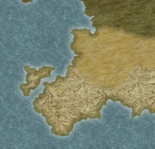
I've been getting pretty good at CC3 after a few maps, and I'm really loving the possibilities. The only problem I haven't been able to fix so far is that any landscapes I put in (desert, farmland, grassland, savanna, tundra, etc.) will fade into the coastline, rather than follow them jaggedly. I could just disable sheet effects, sure, but I want landscapes to fade into one another, just not into the coastline. I know it's possible because in the tutorial pdf the desert hugs against the edges of the continent/island but then fades into the surrounding land. This is using a different map style which could be the problem, but I still followed its directions. I have no idea though, I screwed around with some of the sheet settings but it didn't help anything. Is there anything I can do or do I just need to switch map styles?
Sorry if this isn't the right place for this, or if I'm not being clear enough.
Sorry if this isn't the right place for this, or if I'm not being clear enough.
Comments
Sounds like you need the trace command. Dogtag has an awesome video tutorial on here showing how to use it.
Cal
Ok, I think I know what you are talking about
The way I would do it is to have two desert sheets. The first would have no edge fade on it, and I would use that one to do the desert shape right up to the coast, using the trace command as Calibre suggests. While drawing this poly I would be careful not to go to the full hinterland extent, but only cover the coastal areas where the desert is supposed to meet the ocean.
The second desert sheet (underneath the first desert sheet on the sheet list, and therefore on top of it on the map as you view it) I would do the real desert shape to the full extent - right up to the coast, so that it faded into the surrounding land, but where it comes to the coast it fades into more of itself, giving the impression of a sharp edge that follows the coastline, and a soft edge merging with other climates in the hinterland.
That's only how I would do it, though, and I'm aware this doesn't really help the hard edges right at the edge near the coast
...
A seriously off-piste and definitely NOT recommended idea!...
Another way you could do it is by turning the entire style upside down and having the land fill as the background and drawing the sea on top of everything, so that you can fade things in and out as much as you like to your heart's content on the land beneath it (and wouldn't actually need to trace the coast at all). That means you wouldn't need to have more than one sheet for each climate type BUT... you would have to mess around with all the sheet effects so that the various glows and what have you that are currently on the land sheet are converted to inner glows on the sea sheet.... if you see what I mean - to give the map the same overall appearance as one that hasn't been turned upside down.
However - unless you feel really comfortable with tearing up the rule book and going so far off-piste as to be just a bit lost, I'd go with the first method