

Community Atlas - Ethra (Region Map)
 pixelkitteh
Traveler
pixelkitteh
Traveler
Hi everyone!
I am extremely excited to be a part of the Community Atlas, and have spent the day working on a small section of the magnificent Doriant continent. I love a challenge, so I greedily took a huge area at the southern end of the continent xD I started by drawing out the entire section on one map but I didn't like the scale or how it looked in general, plus it was ridiculously large and who can handle that lag right! So I came up with an idea. Basically I am going to break up the area into "Region" maps, that connect when you put them side by side. They will most likely all be in the same style but I might experiment... I've only had this program for a few days and I want to explore it. Anyway onto the fun stuff!
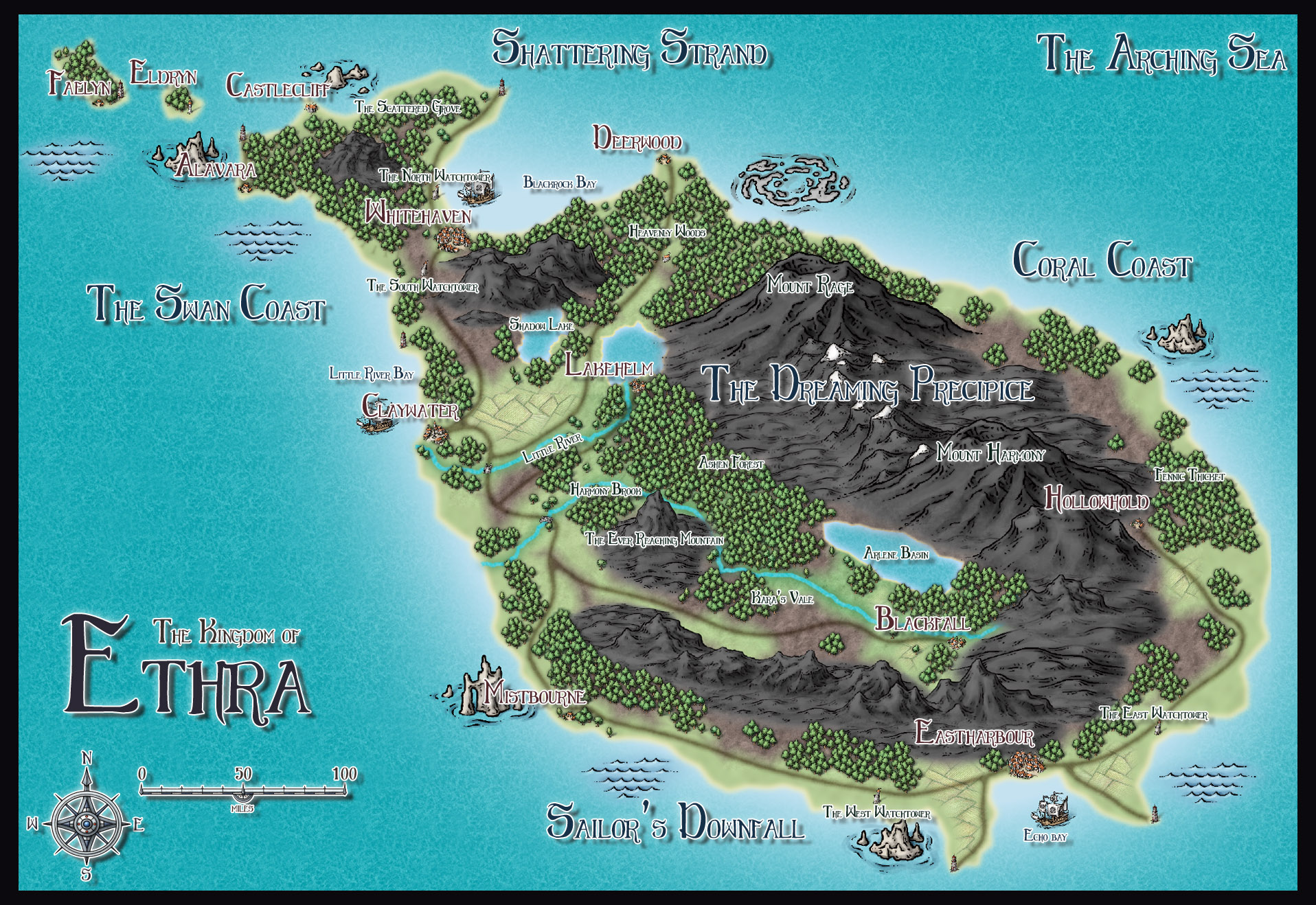
The first map is the island of Ethra. This is not a completed map just yet but it's really coming together! I tried my best to keep the features on the continent map, including the mountains, towns, and rivers etc. The hardest thing was probably the coast! I messed it up a little at the top there but I just kinda went with it and imagined that it's a particularly rocky area of coastline! Lol! I added a few extra towns as it looked a bit bare, and a bit more forest. I tried to make the roads blend nicely, and I thought a small amount of fields filled the empty spaces well. I have it in my head that the people of Ethra expanded their Kingdom to the east and have taken part of the greater land mass of Anorica, and that will most likely be the next map I make. But for now I'm really quite happy with what I've done with Ethra, I hope that it breaths a little bit of life into the region, and somewhat resembles what the original continent artist had in mind.
Also if anything in particular strikes your fancy, please go ahead and take it! Sharing is caring, and there's plenty of areas for all of us.
I am extremely excited to be a part of the Community Atlas, and have spent the day working on a small section of the magnificent Doriant continent. I love a challenge, so I greedily took a huge area at the southern end of the continent xD I started by drawing out the entire section on one map but I didn't like the scale or how it looked in general, plus it was ridiculously large and who can handle that lag right! So I came up with an idea. Basically I am going to break up the area into "Region" maps, that connect when you put them side by side. They will most likely all be in the same style but I might experiment... I've only had this program for a few days and I want to explore it. Anyway onto the fun stuff!
The first map is the island of Ethra. This is not a completed map just yet but it's really coming together! I tried my best to keep the features on the continent map, including the mountains, towns, and rivers etc. The hardest thing was probably the coast! I messed it up a little at the top there but I just kinda went with it and imagined that it's a particularly rocky area of coastline! Lol! I added a few extra towns as it looked a bit bare, and a bit more forest. I tried to make the roads blend nicely, and I thought a small amount of fields filled the empty spaces well. I have it in my head that the people of Ethra expanded their Kingdom to the east and have taken part of the greater land mass of Anorica, and that will most likely be the next map I make. But for now I'm really quite happy with what I've done with Ethra, I hope that it breaths a little bit of life into the region, and somewhat resembles what the original continent artist had in mind.
Also if anything in particular strikes your fancy, please go ahead and take it! Sharing is caring, and there's plenty of areas for all of us.
Comments
Unless you try to put way to much detail into it when compared with the scale, it shouldn't really be laggy even if it covers a huge area. But that is usually the thing you need to be most concerned about when mapping a large area, it is easy to fall into the trap of adding to much detail, generally making everything very tiny and difficult to see from a zoomed out map view, and also creating way to much work for yourself.
Splitting it up is a good idea, but I wouldn't be to converned about making them fit exactly side by side if I were you. Maps that are designed this way often gives unnecessary restrictions on the mapping process, and often leads to important features being split over multiple maps. I would really consider making individual maps of a varying scale and size to fit the current area you are mapping, just like the size of your current map fits the island nicely.
Another option is to make a simple map of the entire area, more detailed than the continent maps of course, but still light on details as appropriate for a map at such a scale, and then make detail "zoom-in" maps for the interesting areas from this map (much like the entire atlas is built). This way, you don't have to map everything to the same detail level.
This is a beautiful map already.
I will be having similar problems with the City of Sanctuary, and following Monsen's advice I will also be doing a series of more detailed maps that cover smaller parts of the city, as well as one main and very simplified one
The biggest thing I was worried about was people not liking that the maps didn't exactly line up but you have put my fear to rest with this comment... I think I'll do it the first way you suggested. I can see how the continent could be broken into smaller region areas that are slightly more detailed than the original continent map, and then from there it would have the zoomed in maps like you said, for towns and areas of interest.
One question for you, is the level of detail I've added to Ethra ok? Is it too much or too little for a map of this scale? I didn't want to overcrowd it but I wanted it to have enough detail that you could see where settlements were and that the big obvious things like mountains and forests had names.
Edit: I have no idea what I did to the blockquotes... just go with it ok >_>
Considering that this island is almost the size of the united kingdom, there are plenty of opportunity to put additional details in a regional map.
Maybe your structure symbols (city/village/lighthouse/etc) symbols are a tad small. Personally, I prefer them to be a bit bigger, making them more visible, especially since they are only there to represent the place, they are not to scale anyway. But this is a matter of opinion, I know other will disagree with me on this.
Note that you can rotate the texts when placing them or you can use "text along a curve" to, well, place texts along a curve. This usually works very nicely on Mountain Ranges, Rivers and Lakes.
I definitely should have done this with Vyrn:P
And the rocks seem a little huge to me, unless this is required in your land.
Finally, the mountain colour is a little overwhelming to me.
Just my thoughts - a great addition to the atlas regardless. And don't forget Map Notes - I will be fascinated by the details of this island.
Thanks very much for the comment!
@Quenten - Hehe we will never all agree on everything it seems! The shading is definitely too much, I will change that when I put the text on the actual map! The rocks... they were meant to be ridiculously large, on the continent map this island has a magnificent spiral of mountains and I wanted to portray that the land, it just keeps going up and up and up into the heavens. And the color of the mountains - I've been to an island in Japan called Sakura-Jima, it's a huge volcano basically, and when I saw this map it reminded me of that. The ground there is black (solidified lava etc) and I thought that would make an interesting map point that this island had these massive black mountains that are probably only found here in the world. I realise that it's kinda overwhelming, but it was intentionally overwhelming :p
As for map notes - oh wow this will be fun as!!! Thank you for your input, it's really interesting to see everyone's differing opinions! :)
I too like the island, but the lighted bevel effect rendered differently than I expected them to do. Anyway, I like what you made of this Island, especially how you scaled the volcanos.
I see your point on the smaller texts. The thing is, texts of this size could be readable - depending on how they are presented - in full view and those who can only be read when zoomed in can be blended in to the map so they do not attract too much attention when viewing the map in full view. In this case, removing the white outline would probably help to make the texts more readable and it would reduce their 'weight' on the overall map. I generally prefer texts to be rather subtle, but that is just my personal opinion.
Anyway, great map. If you need advice on anything just let us know.:)
This is looking fantastic, pixelkitteh
The giant spider lair will be an awesome fungeon I think
Bollocks haha oh gosh such an Aussie thing to say! Bolosh the giant spider it is, that is brilliant!
Thank you Quenten! GO check out the map notes, there's a whole story on there basically! >_<
Everything is a WIP... Everything... just wanted to show the general layout
Maybe you could add a some contours or different texture to emphasize that the whole area in the south is higher above the sea level than the coastal area.
Also, there seems to be something odd with the river at Norbury. Maybe you could try to copy the rivers from the Doriant .fcw file into this one?
This would probably give you a good guidance on the general layout. Having recognized the odd river at Norbury, I realized that the structure of the Mountains differ quite a bit from the original map.
I think Farlight is actually based on the same location on the original map as Hillford is. Because the Valley of the river that leads to Ship's Haven does not offer a mountain range such as the one between Farlight and Khern.
This one is actually found a bit further to the west.
This could be avoided by just copying the rivers. Having said that, I do not mean to blame you for not drawing the rivers exactly as they are in the original map. It is really easy to lose track of the rivers and the valleys. I just realized it myself.:P
Also, of course, you do not have to copy the rivers from the original file. Your map does not have to be an exact rescaled copy of the original map. It is within your artistic freedom to decide on how closely you want to follow the original map.
However, if you decide to follow it, I'd suggest copying the rivers.
I actually didn't realise it was possible to copy things from one map to another but now that I know that oh my god I am going to be copying those rivers across!!
Also what do you think about the place names? I tried to use a mix of human, elvish, and dwarven names to keep it diverse, I like most of them but I'm not 100% on the ones around the coast. I added a few more towns than were on the original map too...all of the smallest ones are my additions, the middle and biggest ones are the originals.
I do like the names, also the ones on the coast. But I would probably slightly amend Ship's Haven, because being a large city it would most likely have a more individual name - that could have derived from Ship's Haven... For example Skiphavn