

City of Sanctuary - version 1
 Loopysue
ProFantasy 🖼️ 39 images Cartographer
Loopysue
ProFantasy 🖼️ 39 images Cartographer
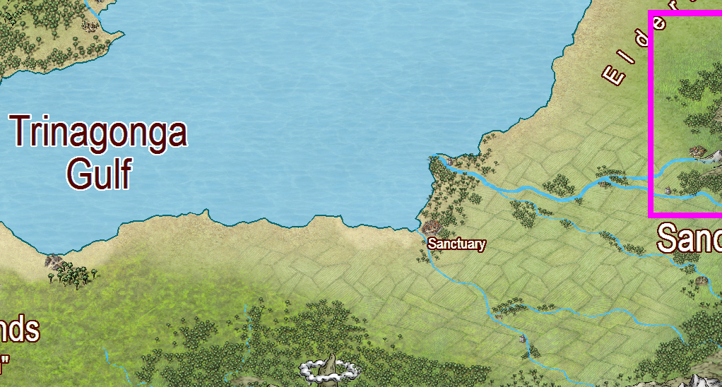
The City of Sanctuary is positioned on the north coast of the southern landmass of Malajuri (beautifully mapped in the Schley style by Lorelei), looking out over the Trinagonga Gulf and the Pelabua Yang Sea. On a global scale its not really all that far to the west of The regional map of Sanctuary Valley, though it appears to lie near the estuary of a separate river of its own, which currently has no name... How about "The River Sanctuary", Lorelei?
[Image_8583]
In the parent map it is more or less surrounded by a tropical forest that lines the shore, so I am assuming that this is a tropical or sub-tropical position and that the climate is reasonably wet - green land. The presence of a massive agricultural apron also suggests the land is far from being a desert.
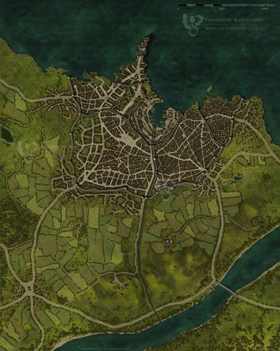
The sample map that Lorelei provided when asked what kind of city map was preferred for this region certainly has a rich green tapestry around it.
[Image_8584]
I have started this thread now, even though I am still not ready to map the city. This is because with Remy's permission (Remy Monsen) I am making a new set of city scale tree symbols and a couple of textures to use in the map. When the map is done these new city trees and fills will be stored in/with the Atlas, and available for others to use in their own maps if they wish.
Many, many thanks to Remy, who will be constructing the actual catalogue from the png symbols I send to him
[Image_8585]
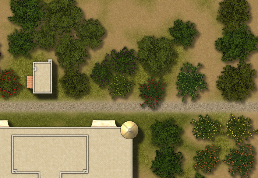
This is only a half way example of what I am doing. The work is very incomplete - as you will note from the total lack of palm trees, though I have already managed to create my first ever varicolour fruit tree symbols for this set.
The tree catalogue and the 2-3 fills I am making will amount to approximately 50MB of download space. I'm curious to know if this is a generally acceptable size?
[Image_8583]
In the parent map it is more or less surrounded by a tropical forest that lines the shore, so I am assuming that this is a tropical or sub-tropical position and that the climate is reasonably wet - green land. The presence of a massive agricultural apron also suggests the land is far from being a desert.
The sample map that Lorelei provided when asked what kind of city map was preferred for this region certainly has a rich green tapestry around it.
[Image_8584]
I have started this thread now, even though I am still not ready to map the city. This is because with Remy's permission (Remy Monsen) I am making a new set of city scale tree symbols and a couple of textures to use in the map. When the map is done these new city trees and fills will be stored in/with the Atlas, and available for others to use in their own maps if they wish.
Many, many thanks to Remy, who will be constructing the actual catalogue from the png symbols I send to him
[Image_8585]
This is only a half way example of what I am doing. The work is very incomplete - as you will note from the total lack of palm trees, though I have already managed to create my first ever varicolour fruit tree symbols for this set.
The tree catalogue and the 2-3 fills I am making will amount to approximately 50MB of download space. I'm curious to know if this is a generally acceptable size?

Comments
Though I can only hope to live up to that lofty description by about 1/4 of the way, or so - if that
You'll see
Aw Lorelei
Do you mind if I add a canal from the upper reaches of the currently nameless river to feed the cascades pouring down from the top levels of the garden? I won't go as far as to cut a canal through a mountain as King Ashurnasirpal did, but I really love the idea of all the waterfalls and a tiered garden with a palace the size of Windsor Castle on top of it all.
EDIT: I'm not the world's most precise historian, since history bored me silly at school :O So if anyone wants to check the story I got it from here:
https://en.wikipedia.org/wiki/Hanging_Gardens_of_Babylon
I won't map the entire course of it or anything - just the bit that comes into the city, so that whoever does the regional map of the hinterland gets to lay in the actual course of it to suit their own map
That's because if it was left to me, it would be a dead straight line, but that's not always the best way to build a canal in a fantasy world, where dead straight lines are usually a bit of a pain in the composition.
By the time the canal gets to the city it will be running across an aqueduct to reach the top of the artificial mountain that results from the building of the hanging gardens.
Who knows - maybe you will end up doing the battle map of the palace one day? Apparently it was about the same size as Windsor Palace!
Remy - in a city map, how many feet in a map unit?
I've worked out the city needs to be at the very least 3 miles in diameter - far bigger than Merelan City. I had the ratio of feet to units wrong in MC right from the start, such that I was having to use the house symbols at 2.5 - 3.5 larger than the default 1, just to compensate for the error.
Since this will be available to everyone, I'd really like to do it right this time.
So by that reckoning the map itself needs to be about 15000 units square...
Is that way too big for the Atlas?
I could do it half that size and use all the symbols at .5 instead of 1?
Technically no, but a map that size will put some strain on the system of anyone opening it (based on the number of entities a map of that size would contain, the size in itself doesn't matter)
Eh, that would only accomplish one single thing, making the information tools in CC3 report wrong distances, nothing else. It would not have any advantages at all for map performance.
I thought 3 miles would be relatively small.
I'm now thinking of doing just 5000 units square - same map size as Merelan City, but with the symbols at 1 instead of 2.5 - 3
Also, Clercon (aka Pär Lindström) addressed the issue of city map size on his blog, though that was also before CC3+ came out.
Cheers,
~Dogtag
[Image_8599]
Only to realise that none of it really matters once the map is rendered out at a scale where I can fit the whole city into 10,000 x 10,000 px
[Image_8600]
Oh well - back to the drawing board!
While there is nothing inherently wrong with the fills I've made, the LOD is unnecessary. They would be fine in a small village map where everything could be rendered out larger, but not so great in a city, where everything is very tiny.
Now that I look at them again this morning I realise that not all is lost. The detail might be invisible to the rest of you, but what I have managed to do is create a set of four textures that are more than just simply plain colours like Bitmap A, but which has virtually no redundancy at all. And with the sand in particular I've somehow managed to do it with a relatively large built in ripple pattern - a notoriously difficult thing to do.
I'm not as unhappy about them now as I was last night, and I may well use them anyway
Ripples?
Oh them! Just a few white lines on three sheets with varying amounts of blur. That's all
Think I need to leave the wave edge sheet a bit less blurry
Remy....
Thanks Remy - I will bear this in mind. For some reason the LOD in Merelan City worked just fine.... and now I think I may have understood that I don't need to create 1000 pi fills, but only 500 pi, or so - since the fills that worked just fine in MC are the ones that I was trying to replace in this map - the comparatively low res Bogie fills.
Still not happy with the grass, but the sand, soil and cobbles are now just about right.
I will never again criticise anyone else's city textures. They don't look right plain (to me), and they look even worse with a bit of texture. Its incredibly easy to either overdo, or underdo it. Overland and dungeon fills are FAR easier!
I did a better one since the one above, as I suddenly had the bright idea of using an 'equalise' node to iron out the light and dark patches in the grass, but its only fractional differences, so I'll leave it at that for now and get on with the palm trees. Better had - since this texturing job was only supposed to take a couple of hours (instead of about 3 days), and be just a bit of light relief from doing the trees! LOL!