

Lining up a reference drawing to DD3+ grid
 JMunsonII
Traveler
JMunsonII
Traveler
Greetings!
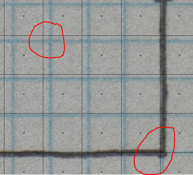
I am having a little trouble getting my reference drawing to correctly line up with the grid.
If you examine the attached, you'll see what I mean - I can't get the reference grid scaled & lined up with the drawing grid. Not sure why this escapes me... Note the bottom right circle shows where the reference grid is closer to the drawing grid, yet the upper left circle shows where the grid is way off.
What's going on here?
Thanks!!!
Jon
Comments
Then I will use the Non-Visual Scale tool (right-click scale tool, select non-visual), which allows scaling by a static ratio instead of by mouse movement.
1. Select the entity (just the item you want to trace), Do It
2. Scale by Factor "distance needed"/"distance is" (might have the ratio backwards)
That should get it as close as possible, it's been in my experience that some paper scans can be distorted and won't exactly match up. This works pretty well in cases where you only have a scale bar, the trick is to find a known measure on the map you're trying to copy.
Good Luck.