

Community Atlas Project - Call for Mappers
 Monsen
Administrator 🖼️ 46 images Cartographer
Monsen
Administrator 🖼️ 46 images Cartographer
 The community atlas project is a project where we as a community makes an interactive atlas together in CC3+.
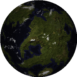
 We have just completed our first stage, the generation and selection of a FT world to be the base for our atlas. We are now ready to begin on stage two, the top-level maps of the continents. Once these are in place, we will move to a stage three, which is less restrictive, and allows people to choose whatever they want to map themselves (Which includes overland maps, city maps, floorplans, dungeons, streets, etc..).
I want people to have as much freedom as possible when designing the maps, but we do need some ground rules for stage two:
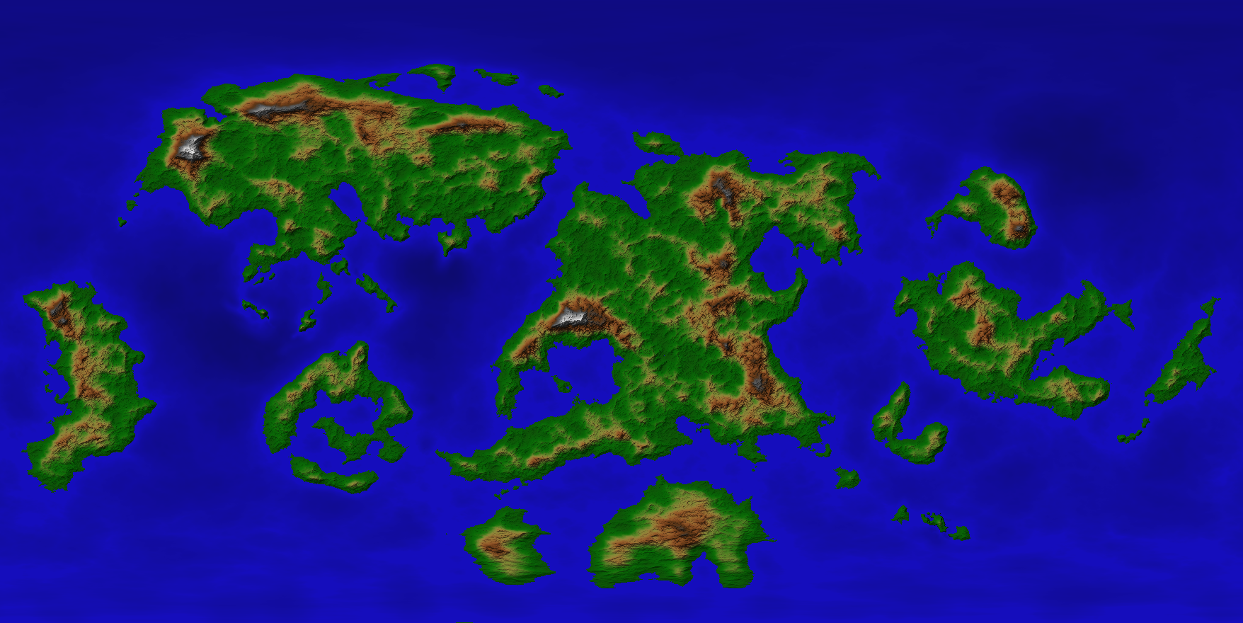
- You will be mapping a continent based on the FT map. Please stick to the coastline as it appears in the map (Adding/modifying small details that wouldn't show up on a world map is fine, as is adding small islands off the coast, this is a normal part of the process of making a detail map from a high-level map, but don't drastically change it)
- Use the mountains on the FT map as a loose guideline for your continent map. Feel free to add additional mountains/hills of course, only the largest mountains are visible on a world map.
- Use one of the core CC3+ map styles (no annuals or add-ons or custom fills/symbols). We want the first level of maps to be able to be opened by anyone owning CC3+. This restriction will be severely relaxed in stage three maps.
- Please respect the scale of the area you are mapping. You are free to use whatever symbol scale you want, but don't try to make a small island into a continent or anything like that. Also, the map should be generally viewable at the 'Zoom Extents' view. If a feature is too small to see/make out from this view, it probably belong on the next map level instead. At the continent scale, only the largest of cities deserve a place on the map.
- Keep latitude in mind when placing terrain features. Glaciers near the equator usually looks weird unless way up high.
- Try to make an interesting map. Remember, for the later stages, other people will be picking areas from your map and making detail maps from it, so make sure they have areas to explore. This also goes the other way, try not to cram to much details everywhere either, leave something up to the imagination of the next level mapper as well
- Remember to label the locations on the map.
- These maps will be hyperlinked together. For now, don't worry about this, I will handle that job for now. Just make your map. I will also prepare the atlas downloads, and have a web-version available so people can browse the maps on the web as well.
- Remember that you must provide the .fcw file to me for the atlas. The atlas maps is meant as a resource for people needing maps, and they will need to be able to edit and manipulate these to fit their own role playing campaigns (or other use). You will retain copyright of the map, but by submitting a map to the atlas you give those that download the atlas the right to modify and use the maps for personal use within their own gaming group. Copyright information should appear in map notes associated with the maps, and if you wish, also as a small non-intrusive notice in the corner of the map. It will be up to you to authorize other uses of the map.
- You can download the FT file yourself to extract the coastlines, or if you prefer, I can do it for you and provide them as an .fcw for you. If you do it yourself, make sure to correctly rescale it in CC3+ after exporting, because the sizes on the export from FT is rarely correct, due to factors such as map projections and the like. You can easily measure distances on the FT map, and then rescale the CC3+ export to match.
- No particular limit. However, it is difficult to proceed to stage three before we have at least some of the continent maps done. So, it would be great if these maps were done in no more than 30 days (sooner is better, but I don't want to rush anyone). If you find you cannot do the map after all, I'd appreciate to be notified, so I can reassign it to someone else interested in mapping that area, but don't get stressed over some delays, we'll survive that. Note that for stage three maps, time means much less.
- Below is an image (click it for higher resolution) of the world divided into segments. Just tell me which section you wish to map, and once I update the list below with your name, you are good to go.
Once you have started mapping, feel free to show off your progress in the forum. We'll all like to see what others are doing.
| A | Shessar |
| B | HadrianVI |
| C | Gathar |
| D | Tonnichiwa |
| E | Shessar |
| F | Quenten |
| G | Quenten |
| H | CharlesWayneRobinson |
| I | Lorelei |
| J | JimP |
| K | CharlesWayneRobinson |
Comments
Now, I hope some people can go for the larger continents too. They are bit more work obviously, but remember, they are top level maps, and we do plan to add more detailed maps, so they needn't be super detailed. The scale is also different from a huge continent to a small one, so the amount of details will differ, so the work level shouldn't be that much different.
Also a note to everyone exporting coastlines from FT3 themselves. Make sure you rescale the export in CC3+ afterwards to match the measurements from FT3. The scale of exports are rarely correct, because of factors like map projection. (Also note that the actual scale bar on the export is always showing 200 miles, so it is always wrong)
Do you need a coastline export, or do you prefer to handle it yourself? We'll get there too. I am really looking forward to getting a multiple of maps from a wide variety of types in here.
I have a question. You said "make sure to correctly rescale it in CC3+ after exporting, because the sizes on the export from FT is rarely correct, due to factors such as map projections and the like. You can easily measure distances on the FT map, and then rescale the CC3+ export to match."
How? Distances at the equator are closer to correct than those nearer the poles. What/where do we base the rescale size on? Or, do you just mean to rescale the overall size of the map to match the circumfrence of the FT map (25000)?
For some reason, this is really boggling my brain.
A is yours.
Since CC3 does not have a deformation type tool to adjust north and south differently, how does one rescale the continent properly? Is there a projection that I should be using other than the equirectangular?
Or, are you saying that I shouldn't bother rescaling since this is for a world map? I'm confused. I'm sorry but I don't know how to make this work.
By that I mean some indication of where the ice sheets are and where might be covered in glaciers... or where there is more likely to be desert/jungle around the equator?
Also - what are we calling this world?
Something like Seesi 3, or Profantasia?
My though here wasn't to ensure perfection though, just to avoid people starting mapping a landmass with wildly inaccurate measurements. We don't need to make it too complicated. Just make sure you think the distances on your map is reasonable compared to the original FT map, within the bounds you feel it is possible.
Don't want a large bit, though!
As for the name - I put forward the two I've already suggested:
"Seesi 3", and "Profantasia"
When others start to contribute their ideas, maybe we could do with another vote?
World Names:
I'll play off of Sue and say - "Profantia"
A Chorale is a song sung by many voices. This is a world drawn by many hands. - "Choralia"
Edited to add: The male form of Chorale - "Choralus"
1. I know the world is 25,000 miles wide when placed out flat.
2. I saved the posted image to my desktop.
3. I opened the image in my graphics program and activated the "ruler" function to get a measurement of the image.
4. I divided 25,000 by the image width to get the ratio factor of 14.3.
5. I measured out my start and stop points for cutting out my section of the world.
6. I subtracted the beginning points from the ending points for width and hieght and multiplied them by the ratio factor to get the measurements needed for determining the map size needed.
7. I created it on campaign cartographer and then built a sheet for the image between the land and sea sheets.
8. I placed the image on that sheet and then traced out the landmasses.
9. I fracticized it twice, with smooth off, to ruff out the coast a little without changing its basic overall shape ( It still matches the original drawing).
10. I then "hid" the image layer and added coastal contours to the sea.
11. Next is to add mountains. When I created Kelleemah, I researched the width range of large mountains. I marked that distance on my map and then scaled the largest mountain symbol to fit that width at the symbol's base. I will do the same here and then zoom out to see how it looks. From their I will adjust as needed to be viewed properly.
12. From their I will add any major waterways, then terrain types, and then major settlements or major items of special interest.
13. Since this is "continent" map, these are all the details that I believe I need (Correct?).
14. For settlements and items of interest, I plan to make icons using the current "current overland style".
15. For me, icons make the most since at this level.
16. For this land, I am taking a "lost world" approach. It is mostly inhabited by primative human tribes, lizardmen tribes, and intelligent carnivorous gorilla tribes. Add dinosaurs, giant insects and such for feel. Plus, a pirate's settlement on the Southern end. Of course, it has to have a volcano, appropriate icons, and some ancient ruins. It comes with two smaller islands. I am going to place a "Aztec" style temple on one and a skull symbol. I am not sure what to do with the other one yet.
17. The basic concept is to give a general map, cultural specific icons and specific place names to set the "feel" for the area and to spark the mapper's imagination.
18. The challenge is do this with the map only (terrain, symbols, icons, and place names).
I thought this would be useful to generate ideas among our group and to eliminate duplication issues.
I have ran across one issue so far. Part of another section overlaps into mine. As such, I cannot map that section until somebody else finishes that one. I am sure that other people will have the same challenge.
13. Sounds like that's about it. Do note that your continent is small (as continents go anyway), so it will probably be more detailed than for example Shessar's.
14. When you say icons, do you mean symbols? Or do you have a special meaning for icons?
16. Sounds interesting
Just ignore landmasses that extends into your map. Maps unfortunately have to be rectangular, and landmasses are not. I think simply leaving such landmasses out are fine (Even if it leaves a bit of sea where the other landmass should be), or leave the coastal outline but just leave it completely blank (default land fill, no features, perhaps even in greyscale to show it isn't part of this map?)
One of the annual map styles has icons. I figured out how to make my own icons in other styles for a commissioned project. I am going to do the same using elements purely from the Mike Schley style.
I don't have FT so that is why I went with the alternative method for scaling.
Thanks Monsen! ?
As for ice sheets and glaciers, since there are no ice caps shown, that leaves open the possibility there may not be any large-scale frozen terrains in the way we find on Earth today. Even on Earth, the polar regions have not always been frozen as they are now, after all. Especially since we already now have one of the continents named ;D
Communia?
*[Edit: Or even Hudson Bay... I knew I'd checked it against Hudson Bay and Baffin Island, so obviously I decided I couldn't decide at the time. Hey Ho.]
I have FT3.
The FT3 file is available for download from the top post, or if you prefer, I can export the coastlines and rescale them properly for you.
Yes please, rescale as I have problems with some math to.
I'll whisper my email address.
Anyway, take your time. Of course, if you want to do it tonight, don't let me stop you, but don't feel any pressure on completing things that quickly.
Sort of, like a coffee maker percolating, bubbling, but not with too fine a filter.
"For general reference and atlas maps, you usually want to balance shape and area distortion."
Since Area A spans from the equator to the arctic, transferring it directly from FT3 to CC3+ results in major discrepancies in distances between the two maps. I have found that the Albers Equal-Area Conic projection gives the most accurate distances at all points when the continent is centered in the FT3 map. (The above link confirms that an equidistant conic is the best projection to use for a continent that spans this distance.) There are still distortions, but they are minor in comparison to the equirectangular projection of our original map. So I feel that I have found a good compromise to bring over from FT3. However, it now looks different than the original image. Similar, but different.
How important is the visual look of the map? Once we have the world map built, will we still be using the FT3 map for anything? Does it or will it matter that my continent is visually different from that in our FT3 image? Are we going for distance over looks?
I hate to keep harping on this subject, but there are other larger continents that will be facing similar questions and it is better to have this figured now before these other landmasses are developed.