CG January 2017 Challenge: Misty Mountains (Map a Song) WIP

Greetings everyone!

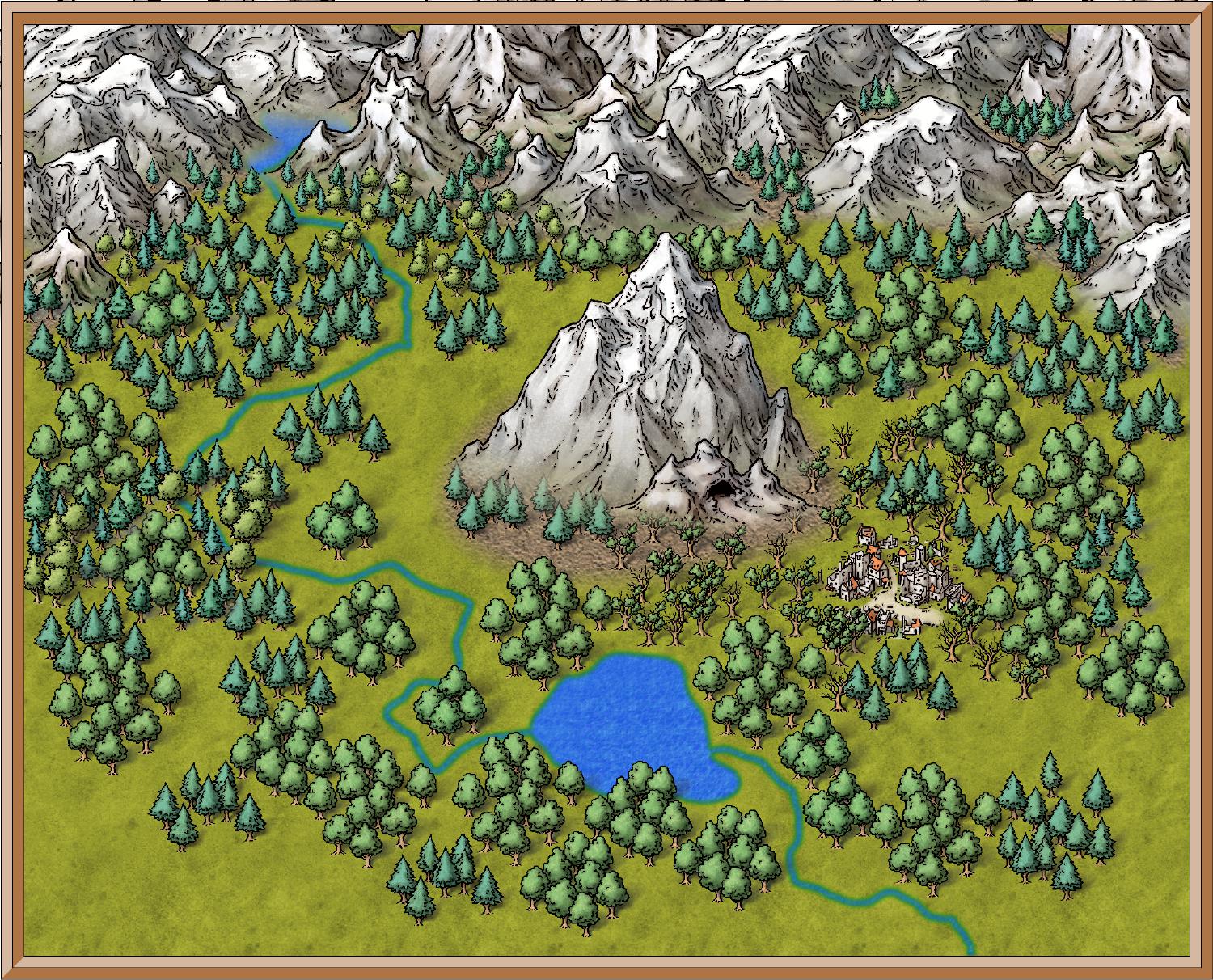
I know, I've been away for a while... between the holiday gifts I had to make, and my normal internet cafe moving to a new location... I haven't had much time for mapping or getting online. And I will hopefully be moving in the next month or two, so I won't be online as much... but I'm still mapping when I can. This is a map I've started for the Cartographer's Guild January 2017 Challenge : Mapping a Song. I've chosen to map the Misty Mountains, from the Hobbit. I'm not done with it yet, but here is what I have so far.

Comments

  • Storm!!! Welcome back! Nice work on this.....but it seems that a few of your trees around the mountain are getting lost....pull them onto a new sheet so they don't fade into the mountain (i've done that with my regional map using schley's style) some of my trees were getting lost in the mountain symbols, too. Otherwise, good stuff. Cant wait to see it finished :)
  • LADIESTORM!

    Hey you! Long time no see over here. There are more trees here than I would have thought there to be. anyway, I can't wait to see it finished either.
  • MonsenMonsen Administrator 🖼️ 46 images Cartographer
    Good to see you back.

    Nice map. I find the close-ups using overland symbols interesting. Makes nice use of the fact that these symbols comes in rather high resolutions.
  • LoopysueLoopysue ProFantasy 🖼️ 39 images Cartographer
    Welcome back, Storm :)

    I've already commented on this one over at the Guild, but I'll say it again here - great start :D
  • GatharGathar Traveler
    Hello !
    As much as I globally like this map, and am impressed with the result you've obtained, I have two small issues not on the map itself, but on its suitability for the challenge:
    - To me, this map is more about mount Erebor and the Iron hills than about the Misty mountains themselves
    - I think the song is very dark and deep, while currently the map is more light-hearted. I don't really know how to change that though. Maybe by toning down some colours?
  • allready working on that... I'm actually trying to make the Misty Mountains like I saw them in the Hobbit. Murkwood was thick and dense. I'm also working on changing the background a bit... but here's what I have so far:
  • 7 days later
  • LoopysueLoopysue ProFantasy 🖼️ 39 images Cartographer
    I like the darker version :)
  • I love the darker tone you have set on this Ladiestorm. It does seem to set the feel for the story a bit better. Great job on this map ")
  • well, I've now hit a snag, I need some help with. This map is pretty much done, I've changed a lot. but for some reason, my new map border isn't showing up. It's not hidden, and it's the last sheet in the stack, so it should be there... but even though I see it, when I save, it's gone.


    Here is my FCW
  • and here is the last save I did, from the fcw
  • as you can see, no map border... I will have to work on this, but if anyone has any ideas... I would love any suggestions!
  • LoopysueLoopysue ProFantasy 🖼️ 39 images Cartographer
    Are you perhaps rendering 'the wrong rectangle' so to speak - giving coordinates that are inside the actual frame?

    Other than that maybe the frame has somehow managed to end up on a layer (not sheet) that is hidden?
  • Wow, what an interesting thing to put on the map! I wasn't expecting ole Smaug to make an appearance burning the whole city down! I like it!
  • Looks great Storm! I had a half a minute and popped open your fcw file.....aside from a couple of the fireballs symbols i didn't have in my own library to import, everything looks ok. I managed to save the frame.....so, stupid question, are you saving the png by rectangle section or just a png bitmap file?
  • I'm actually saving as a jpg, so that I can save it larger...

    something is definitely going screwy at my end, then....
  • LoopysueLoopysue ProFantasy 🖼️ 39 images Cartographer
    You must be giving the wrong coordinates - missing the frame off. If you look at the title you can see that there is more space between the end of it and the inside of the frame than you have in your own picture.
  • MonsenMonsen Administrator 🖼️ 46 images Cartographer
    edited January 2017
    The problem here is the map border (the actual one, not the decorative one). I moved it to the top to visually identify it in my attached rendering (the green rectangle).

    To work around this problem, in the Bitmap Options dialog, simply uncheck the "Restrict Image to Map border" option. But the real permanent fix is to erase the current map border (on the MAP BORDER layer) and draw a new one in the appropriate location.
  • LoopysueLoopysue ProFantasy 🖼️ 39 images Cartographer
    Ah-ha! What would we do without you, Remy :D
  • But the real permanent fix is to erase the current map border (on the MAP BORDER layer) and draw a new one in the appropriate location.
    Is this solution also applicable to a dungeon map that grows in the drawing beyond the initial area defined when setting up the map?

    I remember seeing advice in a dungeon circumstance to instead copy the dungeon onto a new map of sufficient size, but it would seem easier to just erase/redraw the map border in that circumstance.
  • LoopysueLoopysue ProFantasy 🖼️ 39 images Cartographer
    I have gotten into the possibly terrible habit of deleting the frame and leaving it deleted right at the outset. You just need to remember the coordinates of the extent of your map if you do that.

    Merelan City started as a 5000 x 5000 unit map, but with the addition of the frame it became a map that was 5600 x 5600, and which I had to export as a Rectangular Section JPG, giving coordinates -300,-300 to 5300, 5300 to define the render area.

    In the situation where the map just seems to keep growing, having a frame is almost a handicap - though I can understand that its more convenient to have one there to define the extent to be exported if you are not in the habit of using rectangular section exports.
  • MonsenMonsen Administrator 🖼️ 46 images Cartographer
    edited January 2017
    Posted By: EOTBIs this solution also applicable to a dungeon map that grows in the drawing beyond the initial area defined when setting up the map?
    Yes
    Posted By: EOTBI remember seeing advice in a dungeon circumstance to instead copy the dungeon onto a new map of sufficient size, but it would seem easier to just erase/redraw the map border in that circumstance.
    This is because resizing the decorative border around the map is more hassle than copying stuff to a new map. (Unless you increase the map size proportionally in both directions, each edge has to be rescaled and moved individually or the aspect ratio of the border ends up wrong).
    Posted By: LoopysueI have gotten into the possibly terrible habit of deleting the frame and leaving it deleted right at the outset. You just need to remember the coordinates of the extent of your map if you do that.
    Doing that is fine, you don't need a map border at all. The main advantage of it is that it stops drawing tools from going outside the defined area. This is meaningless for Image exports since you can just do a rectangular png which cuts out the border anyway, but if you share the .fcw it can look quite bad. I am unsure why you feel the need to memorize the coordinates for the extents though, they don't have any meaning if you intend to grow the map beyond the original size anyway. And CC3 can always give you the coordinate of any point you want at any point in time.
  • LoopysueLoopysue ProFantasy 🖼️ 39 images Cartographer
    Posted By: MonsenDoing that is fine, you don't need a map border at all. The main advantage of it is that it stops drawing tools from going outside the defined area. This is meaningless for Image exports since you can just do a rectangular png which cuts out the border anyway, but if you share the .fcw it can look quite bad. I am unsure why you feel the need to memorize the coordinates for the extents though, they don't have any meaning if you intend to grow the map beyond the original size anyway. And CC3 can always give you the coordinate of any point you want at any point in time.
    The reason I do it is so that I can simply add the extra onto the old size without having the frame to show me where it was. For example a map started out being 5000 x 5000. I remember that, even though the frame is no longer there to mark the old extent and I add the extra 300 map units I know I have added to the map to the coordinates of a rectangular section jpg export - from -300,-300 to 5300, 5300. If I forget where the frame was (in other words forget how big the map was in the first place) I have to waste a lot of time hovering around both corners to check that I'm about to input the correct coordinates. Its not so easy seeing the numbers when the tiniest movement of the mouse alters the figures by 20 units when you have a very large map shown on a very small screen.

    As to why I have to have the whole map showing - it takes 5 minutes to move the view on Merelan City nowadays with all the effects turned on ready for rendering ;)
Sign In or Register to comment.