

Topographic Game Maps
 mike robel
🖼️ 15 images Surveyor
mike robel
🖼️ 15 images Surveyor
HI all. I've been using CC3/3+ for about 4 years and still an amateur. ") I use it to craft maps for games based on topographic maps. Here is a look at three:
I use it to craft maps for games based on topographic maps. Here is a look at three:
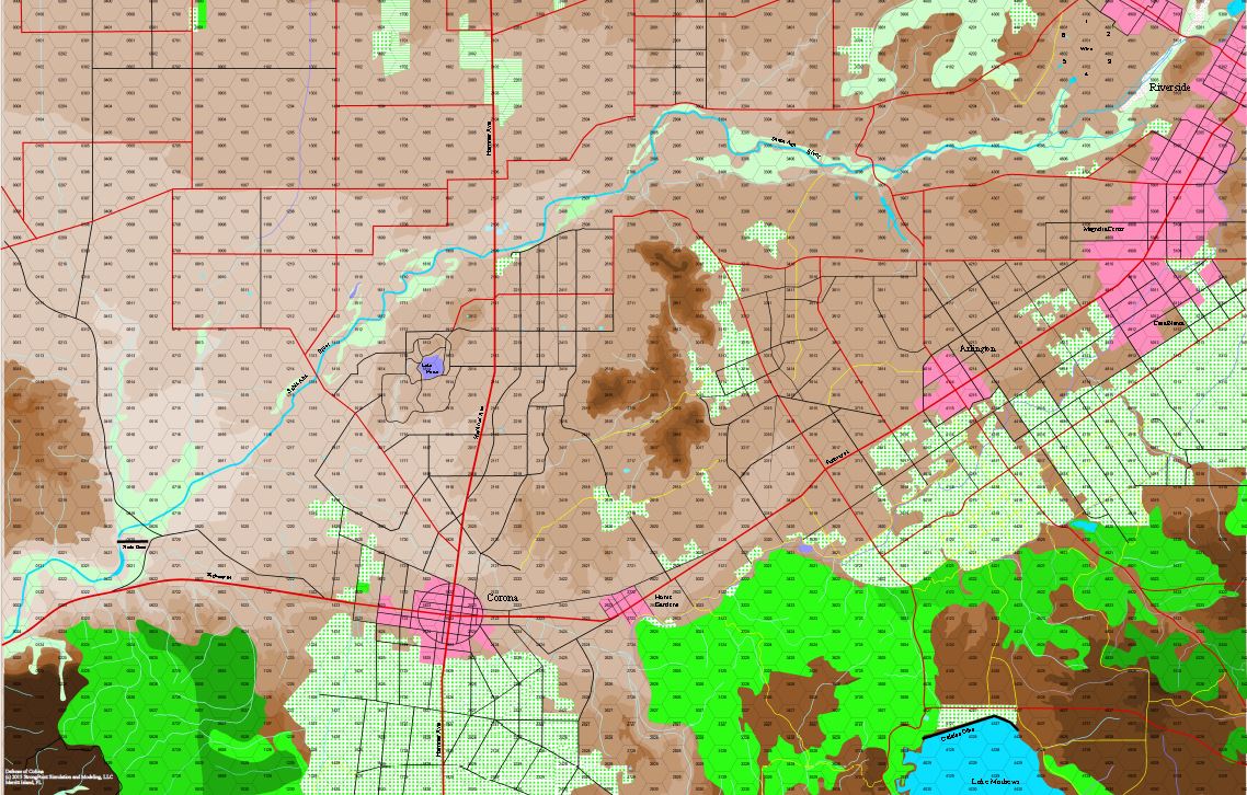
The first is from my Game "Defense of Corona" a game set near the city of Corona, CA (hard to figure that out) in the 1950s as units from the 1st Marine Regiment, the 153rd Regimental Combat Team, and Combat Command A of the 40th Armored Division battle alien invaders.
The 2nd is the area covering the WWII Battle of Arras, in which the British launched a small counterattack that struck behind Romme'ls Panzer Regiment, ran amok for a while causing a lot of damage, and contributed to the German Halt Order which allowed the British to escape at Dunkirk.
The 3rd is still a work in progress based on the US Army National Training Center, it will be used for a game covering Hammer's Slammers (with permission of David Drake.)
Comments
Unfortunately, these are screen shots of pdfs or a view off of Campaign Cartographer because when I try to Save As as JPG, the map retains to quality as you try to zoom in on it.
I print the maps by sending them to CutePDF, usually as 1 sheet. I make the map dimensions equal to the size dimensions of the finished map. The first two print out in 4 -11 x 17 maps, so the size is 22 high x 34 wide in a 1 x 1 sheet . The NTC maps is 15 11 x 17 map sheets. I print it in a file that is 3 wide x 5 high.
The contour maps I download from USGS if possible, or purchase paper maps, cut them up for scanning (which really hurts me), scan them, reassemble them in a photo editing program, save as a BMP, import to CC3+, and then commence to tracing.
Thanks for looking.
Mike
Welcome to the forums. Interesting maps. I used to play a game called Micro Armour, a tabletop minatures game with lots of WW 2 type tanks. These topographical maps would have been great for us to set up battlefields and such. Great job on these.
I am not sure if you knew this or not but there are a few of the Cartographer's Annuals that may help you make maps a little bit easier than what you talk about here.
Issue # 32 is Napoleon Battle Maps. Issue # 57 is Military Operations maps, and Issue # 85 is WW 2 Area Maps.
Of these, all three of them do topography however Issue #85 seems to do it the most.
I have all of the annuals, but I find for my purposes CC3 Standard Overland seems to fit my needs best. I have used overland vector 3 color but it doesn't seem to do as well. I've tried 57 and 85 and they are not quite so useful to me. The main thing I frequently need more than the provided number of contour intervals, so it is easier to just use the brown shades. I keep experimenting though.
I'm a huge dork fan of simple fill styles, I'm dead set on making an original map for gaming that uses the most basic lines to cut down on the distractions of how pretty it is by it being purely functional. This has taken me a few more steps in that direction.
Edit: This map has been superceded by the one five posts down.
I can't imagine how many hours went into making these maps... well I can, but it gives me a headache.
What an achievement!
You know that you can export contours from Wilbur - don't you?
You can import high resolution digital terrain files and export contours in Campaign Cartographer format.
This might ease your hard work on contours a little bit...maybe...
In my example map I marked Setzelbach with a red circle. Contours are drawn in 25m steps...
/André
Um. Nope. I had no idea. What is Wilbur?
With Wilbur you can export contourlines, with Fractal Terrains from Profantasy even coloured contours.
I do not know if there is a tutorial just about this topic here in this forum...
There are many tutorials out there but this I figured out mostly by trial and error...
CA155 covers sculpting a world, exporting it to Wilbur for erosion, then back again to FT3 via an MDR file either way, then from FT3 to CC3.
WeathermanSweden's example looks like what I need, except I guess to be clear, I either scan or convert a pdf map to a BMP, then import that into CC3+. This of course brings in everything, contours and all. I frequently have to stitch several maps together in order to get the terrain coverage I need. When I draw contour lines, i just use a filled Polygon rather than the Contour line function, because they usually don't seem to support reliably changing the fill color from a pattern to a solid color or one color to the other. This is a bother, because you can't backspace to delete a node in the filled polygon. I place each contour on a different sheet/layer. I don't use FT3.
Clearly it looks like you imported the contour lines from a contour map from a 1:100000 scale map and brought it into CC3+, Unfortunately, I don't know the elevation, although I could figure that out, and then I would want to fill them (because apparently many people don't know how to read a contour map), but that is fairly easy, if tedious.
I tend to attack things with brute force and ignorance, finding frequently for me, in the end, it is faster that way than trying to be efficient with other tools.
Thanks. I have that product now.
So, it appears I have to have a map created in FT3, then load it into Wilbur, then bring it ito CC3+.
Or am I able to load a map (say a scanned or digital map like the attached), load it into Wilbur, then export the contours into CC3+? The actual map is about 5 feet square when printed out.
I seem to have other issues, but those will do for a start. It may be I just continue with my previous method (import the map, trace the contours.)
However, something else has occurred to me from what Joe Slayton said earlier on.
That's a real world location. Theoretically... if you could get hold of a data set for that region you could import it to Wilbur and use Wilbur to produce your contours.
If doing that is possible you might have to rely quite heavily on help from Joe, because I have no idea how to convert a CC2 contour map to a CC3+ one.
It is maybe the time for a little tutorial that explains how to produce contours easily from terrain data.
I do not know if I have enough time but I can give it a try during the next days.
I am not sure I can afford terrain data. My little business mostly barely pays for itself plus sometimes some extra for other resources (maps, software, etc.)
Thanks.