

[wip] Venus for Space: 1889
 JimP
🖼️ 280 images Cartographer
JimP
🖼️ 280 images Cartographer
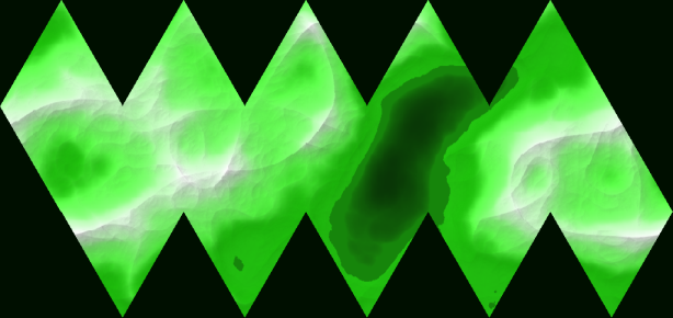
For this game, Venus is a swamp/marsh under the cloud layer. So I have made a preliminary png of Venus. Not much mountainous areas, some lowlands, marshes, and a few lakes...
I went through multiple looks and decided to export and post this one. Likely I will fgo for several more before settling on a final export. Then modify that one in CC3 using the Cosmo hex map, or maybe just go with the regula overland mapping in CC3.
SInce I am making my own solar system for my versioon of the maps for this game, that means i'll also be makinfg maps for; Mars, Mercury, maybe for Earth, some stellites of Jupiter and Saturn, with maybe some for the Kuiper Belt and the Oort Cloud.
Or may just take a nap. Its after lunch and i need one.
Comments
edit: I guess I do nee a nap... I found some 1800s maps of Mars online, along with a Space: 1889 map I might import into this one and use it as a template to trace. Haven't made my mind up yet.
I'm mostly deciding at this point, but I would like some suggestions on which of the two Venus pngs could work.
I downloaded an Earth continent outline map from the Profantasy library. I am going to try and modify some of the continents in that map, for my Earth map.
I hadn't spent much time on this particular map/game, but I hope to at least get some of the planet maps, and maybe the Mercury polar area map done.
I'm sort of leaning to the second one as well.
"Green" Venus version 2 for me as well. Oddly, it has certain similarities to the actual surface of Venus as determined by combined radar and altimetry data collected by the Magellan spaceprobe:
There's a higher resolution version here.
Really liking the look of the redone Mars Map, because it's closer to the style of those hex-maps in the books, I think.
For the sake of completeness, a Mars map based on Viking and Mars Global Surveyor data from Wikimedia Commons:
It's also available in various alternate resolutions here.
I looked and looked, but couldn't find the canals though...
Venus' surface is actually rather molten/moves slowly... its interesting to read old sf stories from the 1940s and 1950s and see how different authors handled what was below the clouds until Venera and other probes showed no large areas of water. Then the radar of Magellan showing the surface changing over time that could only be explained by molten rock. From what I remember, its not moving fast, like a downhill lava flow, but there is enough movement to show it changes and too hot to make a permanent base.
I guess I could use my craft magnifier head thingie, I'll try that later today. It maginfies up to 8x.
Of course, it would help if I posted the png map. eesh.