

World Development

At this point, I have pretty acquired a large amount of ProFantasy software- basically everything adapted for CC3, and Fractal Worlds to boot. My symbol sets are installed, my Annuals are perused, and I'm comfortable with at least a portion of the commands for all of the programs and add-ons. So I figured it was about time that I started working on a project. Of course, most folks would start small. Instead, I decided I'd go big. Very big. I'm building an entire world, starting with Fractal Worlds and working my way down to cities and then individual floorplans as needed or desired. It's a mammoth undertaking and I'm not really sure that I can stick with it long enough to get it all done- but I intend to try.
To start with, here's the world that I created:
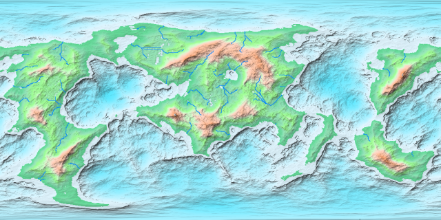
It's built on the same dimensions as the Earth- so I've got my work cut out for me. My biggest problem was adapting it to CC3: attempting to import the entire world created a map that was straining the system just displaying it. So I ended up cutting it down into hemispheres, and got to work.
Grid scale: 500 miles. Still a huge map.
My first task was to start converting it over to bitmaps and extending it out a bit further to reach the map edges. Once I got the basic landmasses converted, it was on to working out the elevation contours for the water- which led to my first problem. There's more water contours than there are bitmaps. So for the very deepest I had to venture into the world of creating my own fill styles by modifying the existing ones. Once I had everything set up and put into place, I started work on the land contours. Unfortunately there's only five land bitmaps in CC3, and there's eight elevations of land in the imported map. So I'll be having to figure out something there to adapt everything. For now, I'm happy how it's turning out.
I ended up putting all of the inputted textures and lines from FW into a single sheet that I used as a template. By placing it above the contour, land, and sea sheets, redrawing got rid of my work so that I could see the next layer to draw in. The deepest areas of the seas I ended up doing on a separate sheet from the other sea contours due to the fact that at the same degree of transparency the darker deep water seemed out of place. Most of the water is at 95%, while the deepest is set to about 35% opacity.
To start with, here's the world that I created:
It's built on the same dimensions as the Earth- so I've got my work cut out for me. My biggest problem was adapting it to CC3: attempting to import the entire world created a map that was straining the system just displaying it. So I ended up cutting it down into hemispheres, and got to work.
Grid scale: 500 miles. Still a huge map.
My first task was to start converting it over to bitmaps and extending it out a bit further to reach the map edges. Once I got the basic landmasses converted, it was on to working out the elevation contours for the water- which led to my first problem. There's more water contours than there are bitmaps. So for the very deepest I had to venture into the world of creating my own fill styles by modifying the existing ones. Once I had everything set up and put into place, I started work on the land contours. Unfortunately there's only five land bitmaps in CC3, and there's eight elevations of land in the imported map. So I'll be having to figure out something there to adapt everything. For now, I'm happy how it's turning out.
I ended up putting all of the inputted textures and lines from FW into a single sheet that I used as a template. By placing it above the contour, land, and sea sheets, redrawing got rid of my work so that I could see the next layer to draw in. The deepest areas of the seas I ended up doing on a separate sheet from the other sea contours due to the fact that at the same degree of transparency the darker deep water seemed out of place. Most of the water is at 95%, while the deepest is set to about 35% opacity.
Comments
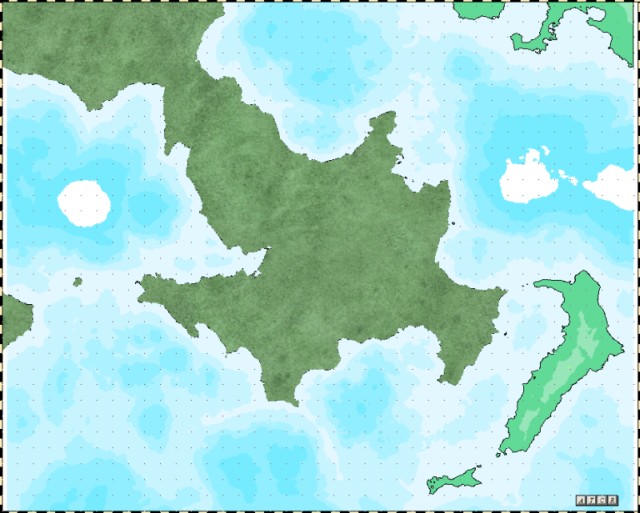
Finished up all of the land contours that indicate elevations, and now I just need to go back in and put down the background for the mountains. I tried to make sure everything blended in well, but I may have overdone it a bit. Because there's a lot more elevations than there are bitmap fills I figure I can take care of the intermediate between the current and the mountains by use of hills, and the variations in elevations of mountains I can achieve by careful choice of symbols- make sure the great peaks get used in the highest, and so forth. I'm hoping that it will work out well.
The scale bar is set to 2500 miles maximum. I did a check on some of the smallest lakes- those are roughly the size of Lake Ontario. The largest inland sea is about 885,000 square miles. Comparatively, the largest inland sea on Earth is the Caspian at about 330,000 square miles. That centralized lake surrounded by mountains is really catching my attention. I'm getting all sorts of ideas with regards to how that came to be. So far most of the ideas keep involving really large rocks from space.
See that little black dot, at the crosshairs? That's a mountain. My desktop's double the size of the image, it's still pretty much a black dot. I think I may have to reconsider scale. That, or settle in for a much, much longer project than I initially anticipated.
I ended up going with a scale of 5.0, which is still relatively small (great peaks are 'only' 50 miles diameter at the base) but allows a general idea as to the varying heights without needing to zoom in too far. Given that the main land mass this map displays is roughly the size of Europe plus Asia, I think this may be the best I can hope for with this style of map.
One problem that I'm running into is a variation between symbols and contours- specifically the fact that there are areas that are not supposed to have forest, yet seem as if they're mistakes if left barren. This is particularly notable where the tree line follows the mountains closely, then suddenly diverges, leaving a pocket of open land that is neither mountainous nor filled with trees. I'm debating whether to overrule that and simply fill it in, or attempt to do something with it using the scrub symbols in order to indicate that it's above the tree line, even if it isn't mountainous.
Lower boreal forests are taken care of. Although that's only a fraction of the total. In theory the entire map, with the exception of some tundra and the water, should be covered in trees. I have neither the intent nor the patience for that. But I do want to have at least the boreal forests in place. I can then be more picky about the deciduous stuff. Also added a large freshwater marsh (distinguished from swamps in the lack of trees) for an area that not only has heavy rainfall but will also have a river running to it from the mountains.
Given that it's the smallest area of its type on the map, a part of me is tempted to name it the Great Swamp. On the basis that they hadn't found the others before that point and by the time they did it was too late to go changing it.