

Maps of my Novel World
 Kathleen Ann Cox
Surveyor
Kathleen Ann Cox
Surveyor
First off, I want to say how wonderful this community is. Yesterday, Monsen (Remy) invested a lot of time and effort in helping me, but everyone on the forum seems really nice and helpful. So KUDOs to all of you.
Second, Loopysue's compliments gave me the confidence to share some of my recent maps. I will tell you what I do, but I tend to make things as hard as I can on myself and others, so you probably want to follow someone else's methods.
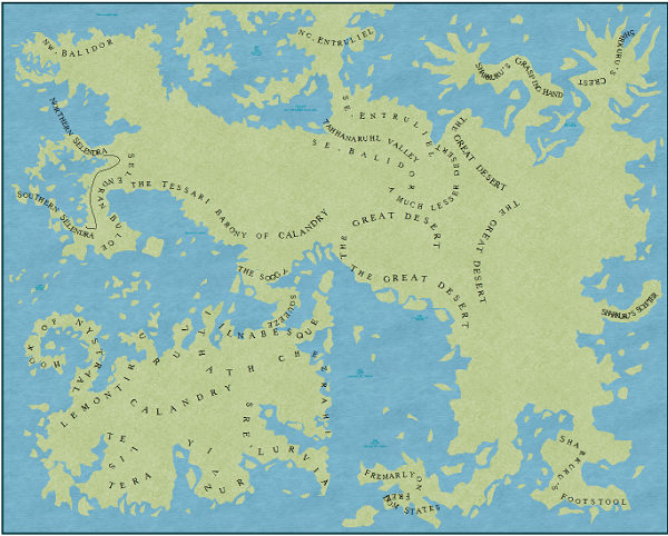
This time, I began with a 4000x3200 Schley style map. The first thing I did was create a sheet named "REGIONS" and slapped a 200mi grid up. Then I checkerboard the map into 1000x800 sections alternating pastel pink and blue. Once I had my checkerboard up, I put text up on the map where I needed certain important locations. Using the tool "draw text along a curve" was really helpful here in sketching out my landmass. Once I had all the vital locations labeled, I started to draw the landmass using the checkerboard for a guide. Using my color guide, I drew my landmass in 1000x800 chunks from the get go. The gridlines helped here to trace along an entity, but I didn't always bother using them. Someday, I plan to put on my grown-up cartographer's pants and learn how to use nodes to break, intersect, etc. but not today. Sometimes I will add the background contours to this map, but I decided to wait to do that on the smaller maps.
Next I create a new 1000x800 map, copy the northwest corner and paste it in. This is where I fill in the details. Once I detail my maps, I want to start seeing them in context, so I paste them back into a consolidated map, but I think 16 small maps merged into one may blow up my computer and the program but I am only on detail map 2, so I have still have high hopes.
And here is the finished product:
Second, Loopysue's compliments gave me the confidence to share some of my recent maps. I will tell you what I do, but I tend to make things as hard as I can on myself and others, so you probably want to follow someone else's methods.
This time, I began with a 4000x3200 Schley style map. The first thing I did was create a sheet named "REGIONS" and slapped a 200mi grid up. Then I checkerboard the map into 1000x800 sections alternating pastel pink and blue. Once I had my checkerboard up, I put text up on the map where I needed certain important locations. Using the tool "draw text along a curve" was really helpful here in sketching out my landmass. Once I had all the vital locations labeled, I started to draw the landmass using the checkerboard for a guide. Using my color guide, I drew my landmass in 1000x800 chunks from the get go. The gridlines helped here to trace along an entity, but I didn't always bother using them. Someday, I plan to put on my grown-up cartographer's pants and learn how to use nodes to break, intersect, etc. but not today. Sometimes I will add the background contours to this map, but I decided to wait to do that on the smaller maps.
Next I create a new 1000x800 map, copy the northwest corner and paste it in. This is where I fill in the details. Once I detail my maps, I want to start seeing them in context, so I paste them back into a consolidated map, but I think 16 small maps merged into one may blow up my computer and the program but I am only on detail map 2, so I have still have high hopes.
And here is the finished product:
Comments
I look forward to seeing more as you progress
It is possible to upload maps that are slightly larger if you wish, so we can all see the detail you have taken so much time to add to this map.
Are those the coloured tops of towers I see in the lower mid-west there?
Its good to see you've got the hang of using the symbols 'off to a T', and that you clearly enjoyed doing this map. It shows. There is just one question that springs to mind almost immediately.
Are those canals you have there, running in gentle blue curves across the map?
I'm assuming the differing coloured mountains represent different regions or kingdoms? That's an interesting idea.... I really like it!
I tried to follow your method...it seems like a LOT of.extrra work....but you what? If it helps you draw amazing maps, and you are okay with his you do them, then do what works for you!
"Ah, Kathleen, keep aspiring, keep aspiring."
My method came about because I think I get a little node happy with my mouse and go clickety-click-click-click to make my landmasses and I never got the hang of using them to break out smaller regions.
Here is the latest incarnation of my world. The needs of my story drive the shape of my map. The difference in the mountain colors on my maps are my feeble attempt of showing the general climate of the region. The north has volcanic regions and also permanent sheets of ice and frost (the bitter blue). The green mountains are located in very humid or rainy regions. I use the map(s) as a visual queue for things pertaining to my novel (climate, background history, distances, etc.), and as the map develops, it influences my story.
Right now, I keep redrawing the map because: I have writer's block; the map gives me insight into the world I am creating; and the map inspires the story (at least it will if I ever get back to writing it).
And loopysue, I am almost embarrassed to admit that those blue things are supposed to be rivers and not canals.
one question about it.
your world map and the two part maps are they the same file or did you make an extra file for the detailed ones?
i want to do the same thing on my map. im just building the world map now and i want to make detailed maps for my islands
Thanks. I figured that was what you had to do, but sometimes my figuring causes me to work harder than I have to.
for the objecitves like Mountain and trees did you use different sizes? and which size for the objectives would you give me as an advice?