It was at the beginning of the world, when there was still only a sea on Nossym. The Gods had asked the giants to shape the world. Every tribe made it for its image.
The tribe of the giants of the South took its time. Every tree, every brook, every hill, every mountain was thought, shaped, sculptured. Every member of the tribe put it all its heart. It was not only the beauty of every element which imported, but also its harmony, there way it resounded with the other elements. The place of every thing was thought, reflected. But it took time.
They had shaped only the island of Marreic, that the other giant's tribes had already created continents entirely.
The east tribe had already raised the chains of the ice-cold mountains of Kara Dag, the valley of Eirroc and the mounts of Altra Dag ... Then they had levelled the desert of Agadur. They had sculptured Elke Dag's mounts, in the South of the desert in a vertiginous speed and moved forward westward.
Their work was not ugly, the fertile plain of Illirag in the South of mounts Elke Dag was made a success enough. But elements were rough, abrupt. There was no harmony. Rivers opposed plains and overflowed regularly. Mountains were dangerous, the collapses were frequent. The desert offered no peculiarity on thousands of miles. The climate was rough.
The east tribe pursued its advance westward, and went from now on to the island of Marreic. The tribe of the South did not look favourably on this advance. They did not want that their works, so different, be invaded by the one from the east. To avoid the conflict, they asked for the arbitration of the Gods. But we know that the time of the Gods is not the one of the Giants and even less that of the Men. The Gods had not made their verdict yet that the first mounts of Elke Dag appeared to the horizon of the island of Marreic.
In front of the silence of the Gods, by despair, to protect their work, the tribe of the South took a resolution. They chose the biggest and the strongest of them. A giant named Crau. They sent him through what we call today the strait of Marreic with an immense axe, forged by the most skillful of the giants of the South. He reached the most westerly point of the construction site of the eastern giants, took place in front of the last shaped mountain and all at once, he split it in two. The mountain parted in two as a log and half lay down in the sea, by forming an island. Crau promised to the east tribe that any other assembly shaped on the West by this one would undergo the same fate.
Giant ignored everything of the war, they were not one ounce of aggressiveness. The gesture of Crau surprised everybody, included the Gods and the story of the split mountain traveled the world as a shock wave. The silence reigned there for a while, before slowly, giants' tribes resume their work.
Bewilder, the east tribe résumés its work northward, leaving the mountain split by Crau as the most westerly point of the mountains of Elke Dag. It took the name of Alycrau - the blow of Crau.
As for the giants of the South, the y stopped widening the island of Marreic and spent the rest of the Time of the Giants to perfect their work. What makes that still today, the Island of Marreic is thought of as the most beautiful place of Nossym
That a beautiful city map, and a great, mythic, background story!
Did you make this map with CC3 only, or did you use any add-ons, such as City Designer? The colors you chose to use for the map are very pleasing to the eye. The city blocks look very realistic. I also really like the harbor! Where did you get the ship and boat symbols?
This is a wonderful first map to post to the forum. Thank you for sharing it with us.
Thanks for your comment ! I'm glad you like this map.
Of course, I used City Designer too... Actually, I'm never really sure when I use CC3 or City Designer... they really work well together. For the ships, I draw them myself with another software.. I hadn't see that you can find some nice ships with Profantasy... And I should change some of them, I think, because they are made in too low resolution.
Anyway, I thank you for your post ! It's nice to have nice comment after a few month of work (I can draw only once or twice a week... ) Now I'll look for some of your work !
I hope I can soon post other maps (I made 4-5 other maps with CC3, but I want to work more on it before I post them).
I've been looking to your work on the forum. And i like what you're doing too ! Looking forward to see more of it ! Aren't you in the Cartographer's guild too ? It seems to me that I've seen some of your word there too...
I've been looking to your work on the forum. And i like what you're doing too ! Looking forward to see more of it ! Aren't you in the Cartographer's guild too ? It seems to me that I've seen some of your word there too...
Have a nice day !
Hi Jo. Thanks for the compliment, and yes, I also follow Cartographer's Guild, only my name there is "Mouse", not Loopysue
oh, this is just a lovely map. Really nice work on this. I especially love the harbor! And that border is divine Please post some of your other work, if they're half as good as this, i can't wait to see them!
Posted By: Loreleioh, this is just a lovely map. Really nice work on this. I especially love the harbor! And that border is divine Please post some of your other work, if they're half as good as this, i can't wait to see them!
Thanks a lot !
I've seen your map too on the Cartographer's guild ! I love it !
I've 5 other map... but I want to work on them again.. They're far from this one... I've already started but I can only draw 2 days a week at best...
I really like you map, you made a really effort with 3D view, and your style is half between realistic and symbolic, which is quite nice. However, there is a place I can't quite read: What is this black thing between the top of the city and the wall?
Hi Jo. Thanks for the compliment, and yes, I also follow Cartographer's Guild, only my name there is "Mouse", not Loopysue
Mouse ! I was sure I had seen your work !!! You're more famous to me with your map than your name ! I look forward to see more of it soon !
I'm sorry Jo, I missed your message because it got included in your quote of me. 'Famous', I think, is taking it a little too far, unless you are referring to the recent stir that was caused when several of our maps appeared without our permission on someone elses battlemap site! LOL. I do remember having rather a lot to say about that, in which case I might have built myself a bit of a reputation, although I'm not sure its one I'm very proud of having!
You make beautiful maps yourself... and by they way, I read the thread for this map on Cartographer's Guild. I really wouldn't place that much importance on what some of the comments say - not when they are about someone elses personal preferences. What's really important, is that you feel happy in yourself at what you have achieved. I like what you have done
It's supposed to be cliffs (with a rock much darker than the rest of the map, because at that point, the cliff is much steeper (is that the right word ?) ) Apparently, it's not that obvious ;-) !!!
Hi Jo. Thanks for the compliment, and yes, I also follow Cartographer's Guild, only my name there is "Mouse", not Loopysue
Mouse ! I was sure I had seen your work !!! You're more famous to me with your map than your name ! I look forward to see more of it soon !
I'm sorry Jo, I missed your message because it got included in your quote of me. 'Famous', I think, is taking it a little too far, unless you are referring to the recent stir that was caused when several of our maps appeared without our permission on someone elses battlemap site! LOL. I do remember having rather a lot to say about that, in which case I might have built myself a bit of a reputation, although I'm not sure its one I'm very proud of having!
You make beautiful maps yourself... and by they way, I read the thread for this map on Cartographer's Guild. I really wouldn't place that much importance on what some of the comments say - not when they are about someone elsespersonalpreferences. What's really important, is that you feel happy in yourself at what you have achieved. I like what you have done
Thanks for your message. Food for thoughts...
There's truth in what you say : I can't make a map that pleases everyone... and you're right : when it's about personal preferences, it's not something I should absolutely fix.
But I'm eager to improve my drawings, so I'm really fond of remarks, comments (as the ones from Gathar, just above : if my cliffs are not obvious, that means I've made something wrong)
When I was referring to the famous "mouse", I was more referring to your work than to your debate about the use of maps on another site... which I fellowed and was very interesting nevertheless.
I hope all is well for you and I'm looking forward to see/read more from you !
Thanks Jo, but now... Turning the focus back onto you...
You've burst onto the scene with a glowing start. Keep up the good work.
If you are really concerned about that cliff, you might be interested in Shessar's Cliffs and Streams tutorials. I expect that with your talent you will be able to adapt some or all of Shessar's techniques to suit your own style of mapping.
If I may put my 2cents in, this is a beautiful first map! I'm currently working on a city map, as well, so I KNOW how difficult and time consuming it can be!
I really like the colors and textures of this map, love the ships... and I'm amazed at how small you were able to make those buildings! I simply CAN'T work on anything in that small of a scale. The map border is beautiful! and I like the corner tiles you added, that's a really nice touch! I may borrow that idea someday if I can make it work(if you don't mind )!
I thought I saw you on the guild forums... I believe you were looking at some of the lite mapping challenge maps?
Posted By: LadieStormIf I may put my 2cents in, this is a beautiful first map! I'm currently working on a city map, as well, so I KNOW how difficult and time consuming it can be!
I really like the colors and textures of this map, love the ships... and I'm amazed at how small you were able to make those buildings! I simply CAN'T work on anything in that small of a scale. The map border is beautiful! and I like the corner tiles you added, that's a really nice touch! I may borrow that idea someday if I can make it work(if you don't mind )!
I thought I saw you on the guild forums... I believe you were looking at some of the lite mapping challenge maps?
Indeed ! I like your map : a lot of details for your bandit camp. I especially liked the ambiance : the shadow puts a lot to it. Great work !
I was beginning to wonder which map you were talking about, as I have several up there . I just posted the next rendering, but I just realized I can make a lot of changes to it... so it may look REALLY different the next time I post something.
Posted By: - JO - It's supposed to be cliffs (with a rock much darker than the rest of the map, because at that point, the cliff is much steeper (is that the right word ?) ) Apparently, it's not that obvious ;-) !!!
I'll try to find something else...
Don't feel obliged to change it, it's your map after all!
There a several points that make it difficult for me to interpret as a cliff: - There is a very straight road (is it really a road?) crossing it. I think a real road would wind through the cliffs, trying to find a not too steep slope. - Your contour lines don't seem to match this cliff. Or maybe it's just that we don't see them that well on the dark background? - If I understand correctly, the wall sits on the ridge line. So the houses close to the dark area are at the bottom of the cliff, is that so? If yes, maybe adding some shadow from the cliff on the town would help the understanding?
Hmm... I have found out that some parts of long distance trails; like the Appalachian, Pacific Crest, etc.; do use switchbacks, but there are paths that go straight up the side of the elevation. I've seen roads done the same way, just not as often.
You could turn it into a funicular? (counterbalanced carriages that travel up and down cliffs) We call the paths they cut into the cliffs 'inclines' around here (Portland, UK is only 3 miles from my doorstep).
I chose this historical picture to show you, because there are no trees in it and you can clearly see both techniques of getting people and things up and down very steep slopes in a real and practical application.
Mind you, if you do that, you would have to set the road into a relatively deep cutting, and start it quite a long way back from the edge of the cliff, which might give you all kinds of representational problems!
Actually, it's not a road, it's a lift. If you could zoom in, you would see a kind of railroad and an elevator cage...
It's quite realistic when you see it close, but I realise it's not the point of a map to have to zoom in to understand what is what.
Maybe I could double it ? Like on the historical picture above ? It might be easier to understand ?
I could enlarge it too, but then the scale would be wrong...
I thougt about the shadow of the cliff on the city... but that's where I reach the limit of what I've done : is it a picture from the sky or is it a map ? It it's a picture, then I should draw the shadow of the cliff on the city, but then, there should be no contour lines. If it's a map, the shadow must be limited to the relief...
The "easy" solution, would be to put labels on some of the elements of the map and a list of these elements (lift, lighthouse, fortress, outpost, bridge...)
I will try some modifications next week-end : shadow over the city, contour lines more apparent on the cliff, double the lift (or anything to make it appear more like a lift)
Anyway, thanks a million for your remarks : I've been working on this map since a couple of months now (only on week-ends...) and I've lost perspective, because I know it too well. So I'm glad to hear comments and questions, so I can learn what is unclear and try to fix it !
All the best to you all !
PS : In case you're wondering, between the lighthouse and the outpost, up north, it's not a road, it's a rope bridge... ;-) ... Was that clear at first glance ?
The rope bridge is a lot clearer on a larger image
An incline like the one I showed you is technically a "funicular", so if you decide to start adding names to things you might call it something with funicular at the end? I would be careful about adding too many names, since words can clutter and even spoil a map. Use sparingly, like salt in a meal. Just enough, not too little, and never too much
Is a map a photograph? That's very much a question of style, really. If you look at all the different styles you can see here, and on Cartographer's Guild, you will understand that there are a whole range of styles between and including all the extremes - all of them equally beautiful.
The only important thing is that you try to retain a consistency of style across the same map. For instance, if you were to find a top-down photograph of a funicular to improve the understanding of the map reader, it would certainly look a bit odd against the rest of the map, which is more towards the symbolic end of mapping than the photographic end.
You're right about names. Originally, I had'nt planned to add names on this map, but I realize it's an ambitious map, because of the unusual topography.
I'll think about it carefully.
And of course, there's no question about adding a photograph of an element on a drawn map.. yiik !
Posted By: - JO -You're right about names. Originally, I had'nt planned to add names on this map, but I realize it's an ambitious map, because of the unusual topography.
I'll think about it carefully.
And of course, there's no question about adding a photograph of an element on a drawn map.. yiik !
LOL. I didn't think you would, JO. I was just rambling on about consistency of style


Comments
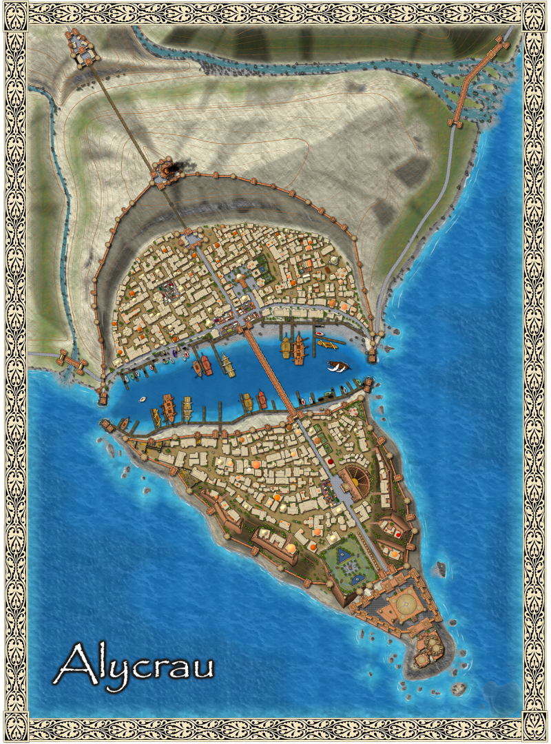
Alycrau
It was at the beginning of the world, when there was still only a sea on Nossym. The Gods had asked the giants to shape the world. Every tribe made it for its image.
The tribe of the giants of the South took its time. Every tree, every brook, every hill, every mountain was thought, shaped, sculptured. Every member of the tribe put it all its heart. It was not only the beauty of every element which imported, but also its harmony, there way it resounded with the other elements. The place of every thing was thought, reflected. But it took time.
They had shaped only the island of Marreic, that the other giant's tribes had already created continents entirely.
The east tribe had already raised the chains of the ice-cold mountains of Kara Dag, the valley of Eirroc and the mounts of Altra Dag ... Then they had levelled the desert of Agadur. They had sculptured Elke Dag's mounts, in the South of the desert in a vertiginous speed and moved forward westward.
Their work was not ugly, the fertile plain of Illirag in the South of mounts Elke Dag was made a success enough. But elements were rough, abrupt. There was no harmony. Rivers opposed plains and overflowed regularly. Mountains were dangerous, the collapses were frequent. The desert offered no peculiarity on thousands of miles. The climate was rough.
The east tribe pursued its advance westward, and went from now on to the island of Marreic. The tribe of the South did not look favourably on this advance. They did not want that their works, so different, be invaded by the one from the east. To avoid the conflict, they asked for the arbitration of the Gods. But we know that the time of the Gods is not the one of the Giants and even less that of the Men. The Gods had not made their verdict yet that the first mounts of Elke Dag appeared to the horizon of the island of Marreic.
In front of the silence of the Gods, by despair, to protect their work, the tribe of the South took a resolution. They chose the biggest and the strongest of them. A giant named Crau. They sent him through what we call today the strait of Marreic with an immense axe, forged by the most skillful of the giants of the South. He reached the most westerly point of the construction site of the eastern giants, took place in front of the last shaped mountain and all at once, he split it in two. The mountain parted in two as a log and half lay down in the sea, by forming an island.
Crau promised to the east tribe that any other assembly shaped on the West by this one would undergo the same fate.
Giant ignored everything of the war, they were not one ounce of aggressiveness. The gesture of Crau surprised everybody, included the Gods and the story of the split mountain traveled the world as a shock wave. The silence reigned there for a while, before slowly, giants' tribes resume their work.
Bewilder, the east tribe résumés its work northward, leaving the mountain split by Crau as the most westerly point of the mountains of Elke Dag. It took the name of Alycrau - the blow of Crau.
As for the giants of the South, the y stopped widening the island of Marreic and spent the rest of the Time of the Giants to perfect their work. What makes that still today, the Island of Marreic is thought of as the most beautiful place of Nossym
Excuse my english.. not my first language...
That a beautiful city map, and a great, mythic, background story!
Did you make this map with CC3 only, or did you use any add-ons, such as City Designer? The colors you chose to use for the map are very pleasing to the eye. The city blocks look very realistic. I also really like the harbor! Where did you get the ship and boat symbols?
This is a wonderful first map to post to the forum. Thank you for sharing it with us.
Cheers,
~Dogtag
Thanks for your comment ! I'm glad you like this map.
Of course, I used City Designer too... Actually, I'm never really sure when I use CC3 or City Designer... they really work well together. For the ships, I draw them myself with another software.. I hadn't see that you can find some nice ships with Profantasy... And I should change some of them, I think, because they are made in too low resolution.
Anyway, I thank you for your post ! It's nice to have nice comment after a few month of work (I can draw only once or twice a week... ) Now I'll look for some of your work !
I hope I can soon post other maps (I made 4-5 other maps with CC3, but I want to work more on it before I post them).
Have a nice day !
I've been looking to your work on the forum. And i like what you're doing too ! Looking forward to see more of it !
Aren't you in the Cartographer's guild too ? It seems to me that I've seen some of your word there too...
Have a nice day !
I've seen your map too on the Cartographer's guild ! I love it !
I've 5 other map... but I want to work on them again.. They're far from this one... I've already started but I can only draw 2 days a week at best...
However, there is a place I can't quite read: What is this black thing between the top of the city and the wall?
If I understand you well, the black thing on the top of the mountain is the smoke of the fire which is on top of the lighthouse tower...
Maybe I should put out the smoke and let just the fire ?
In a distant future, I want to draw a view of the city from the sea... I just need the time that I haven't...
Tell me if it's that black thing you were talking about... or if it's another ?
You make beautiful maps yourself... and by they way, I read the thread for this map on Cartographer's Guild. I really wouldn't place that much importance on what some of the comments say - not when they are about someone elses personal preferences. What's really important, is that you feel happy in yourself at what you have achieved. I like what you have done
It's supposed to be cliffs (with a rock much darker than the rest of the map, because at that point, the cliff is much steeper (is that the right word ?) )
Apparently, it's not that obvious ;-) !!!
I'll try to find something else...
Anyway, thanks for your comments !
There's truth in what you say : I can't make a map that pleases everyone... and you're right : when it's about personal preferences, it's not something I should absolutely fix.
But I'm eager to improve my drawings, so I'm really fond of remarks, comments (as the ones from Gathar, just above : if my cliffs are not obvious, that means I've made something wrong)
When I was referring to the famous "mouse", I was more referring to your work than to your debate about the use of maps on another site... which I fellowed and was very interesting nevertheless.
I hope all is well for you and I'm looking forward to see/read more from you !
You've burst onto the scene with a glowing start. Keep up the good work.
If you are really concerned about that cliff, you might be interested in Shessar's Cliffs and Streams tutorials. I expect that with your talent you will be able to adapt some or all of Shessar's techniques to suit your own style of mapping.
Shessar's streams tutorial
Shessar's cliffs tutorial
Happy mapping
A lot of good ideas in those tutorials !
I'll study them as soon as I found mapping time ("m" not "n") !
Have a nice day !
I really like the colors and textures of this map, love the ships... and I'm amazed at how small you were able to make those buildings! I simply CAN'T work on anything in that small of a scale. The map border is beautiful! and I like the corner tiles you added, that's a really nice touch! I may borrow that idea someday if I can make it work(if you don't mind
I thought I saw you on the guild forums... I believe you were looking at some of the lite mapping challenge maps?
There a several points that make it difficult for me to interpret as a cliff:
- There is a very straight road (is it really a road?) crossing it. I think a real road would wind through the cliffs, trying to find a not too steep slope.
- Your contour lines don't seem to match this cliff. Or maybe it's just that we don't see them that well on the dark background?
- If I understand correctly, the wall sits on the ridge line. So the houses close to the dark area are at the bottom of the cliff, is that so? If yes, maybe adding some shadow from the cliff on the town would help the understanding?
I chose this historical picture to show you, because there are no trees in it and you can clearly see both techniques of getting people and things up and down very steep slopes in a real and practical application.
Mind you, if you do that, you would have to set the road into a relatively deep cutting, and start it quite a long way back from the edge of the cliff, which might give you all kinds of representational problems!
Actually, it's not a road, it's a lift. If you could zoom in, you would see a kind of railroad and an elevator cage...
It's quite realistic when you see it close, but I realise it's not the point of a map to have to zoom in to understand what is what.
Maybe I could double it ? Like on the historical picture above ? It might be easier to understand ?
I could enlarge it too, but then the scale would be wrong...
I thougt about the shadow of the cliff on the city... but that's where I reach the limit of what I've done : is it a picture from the sky or is it a map ? It it's a picture, then I should draw the shadow of the cliff on the city, but then, there should be no contour lines. If it's a map, the shadow must be limited to the relief...
The "easy" solution, would be to put labels on some of the elements of the map and a list of these elements (lift, lighthouse, fortress, outpost, bridge...)
I will try some modifications next week-end : shadow over the city, contour lines more apparent on the cliff, double the lift (or anything to make it appear more like a lift)
Anyway, thanks a million for your remarks : I've been working on this map since a couple of months now (only on week-ends...) and I've lost perspective, because I know it too well. So I'm glad to hear comments and questions, so I can learn what is unclear and try to fix it !
All the best to you all !
PS : In case you're wondering, between the lighthouse and the outpost, up north, it's not a road, it's a rope bridge... ;-) ... Was that clear at first glance ?
An incline like the one I showed you is technically a "funicular", so if you decide to start adding names to things you might call it something with funicular at the end? I would be careful about adding too many names, since words can clutter and even spoil a map. Use sparingly, like salt in a meal. Just enough, not too little, and never too much
Is a map a photograph? That's very much a question of style, really. If you look at all the different styles you can see here, and on Cartographer's Guild, you will understand that there are a whole range of styles between and including all the extremes - all of them equally beautiful.
The only important thing is that you try to retain a consistency of style across the same map. For instance, if you were to find a top-down photograph of a funicular to improve the understanding of the map reader, it would certainly look a bit odd against the rest of the map, which is more towards the symbolic end of mapping than the photographic end.
I'll think about it carefully.
And of course, there's no question about adding a photograph of an element on a drawn map.. yiik !