

Errispa 3
 Loopysue
ProFantasy 🖼️ 39 images Cartographer
Loopysue
ProFantasy 🖼️ 39 images Cartographer
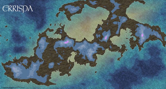
I've finally settled on a landmass that seems to work with the story, and doesn't look too bad as a shape in its own right. (I wasn't happy with the original, or the second one).
I thought it would be interesting to upload the map at various stages of development. Here, after 10 hours searching and searching through the worlds on FT3, is the outline landmass, with the contours still only "roughed in". I find it distracting to work without a finished ocean in the background, so that comes first, for me. Once I have the ocean just the way I want it for a 'pin up poster' type map (by bending the rules all over the place), the rest seems to come more easily - but then I'm very colour sensitive. I'd have done the colours even brighter, and even more unusual, but this will do for now until I start setting up the major features of the landmass, so I can compare and adjust the hue, chroma and contrast.
I thought it would be interesting to upload the map at various stages of development. Here, after 10 hours searching and searching through the worlds on FT3, is the outline landmass, with the contours still only "roughed in". I find it distracting to work without a finished ocean in the background, so that comes first, for me. Once I have the ocean just the way I want it for a 'pin up poster' type map (by bending the rules all over the place), the rest seems to come more easily - but then I'm very colour sensitive. I'd have done the colours even brighter, and even more unusual, but this will do for now until I start setting up the major features of the landmass, so I can compare and adjust the hue, chroma and contrast.
Comments
The red lines mark mountain chains based on the FT3 relief export. White lines are sketched areas of vegetation/climate types (imagined, not from FT3). Mountains and basic climates in place through most of the tropics. A few names added ad hoc (thought of whilst working and added to prevent them being forgotten). Ocean altered, but may go back to the original.
I exported the map to CC3+ from a world I created in Fractal Terrain 3, which included three sea depth contours. These I put on separate sheets and re-textured with Herwin Wielink's "Ocean blue".
Since the ocean contours were on different sheets I was able to use different effects on each sheet to vary the colour, intensity etc, and to blend each contour with its neighbours to get rid of the hard lines of the original.
In addition to this I generated a purely fictitious oval of the same material on its own layer above the others to give the effect of the brighter "flash" at equator level.
For some reason I keep crashing CC3+ when I try to delete all the extraneous sheets to make a simplified version with just the oceanic sheets in it. When I succeed in doing that I will upload a copy of the simplified file for you to be able to have a closer look at it without all the rest of it getting in the way of the understanding.
Is there a reason you didn't really draw an rivers etc?
Herwin Wielink is one of the most beautiful mapping styles I have ever seen. I love using it. There aren't as many fills as there are with other styles, but you can use the same fill with different effects, like with the grass sheets I mentioned earlier. I also find that "forest small" can be adapted (by means of adding a hue, saturation effect) to represent chaparral growing on the slopes above jungles, and both deciduous and fir tree forests. You just have to have three different sheets to represent each particular shade.
I love it, just some of the fill styles make me wonder how I could ever use them.
And I just want to learn more perspectives and you made a beautiful map so I thought I'd ask
Unless it is hollow (only an outline), every shape you draw on a map has a fill, even if it is only filled with a plain colour. I made a new sheet to put the oval on, then drew the oval on that sheet using the draw circle tool (If you right click the draw circle tool you will find the ellipse tool listed in the variables).
Retexturised... is my personal slang for changing the fill properties (sorry), which can be done using the change fill properties button. If you have drawn an ellipse it will automatically fill with whatever fill is shown in the properties bar. Alternatively you can change the fill shown in the properties bar before you draw your oval by clicking the properties bar where the fill is described
I don't really use FT3 to its full potential, and I haven't learned even just a tenth of what it can do. I tend to use it to generate realistic looking land masses on which to base my CC3+ worlds, which is kind of an insult to the power of the software.
Exporting can sometimes be a bit tricky. If you export an entire world you can end up with a CC3+ map that is unnecessarily massive and far too complicated for the average laptop to handle properly once you start to get to town with the business of drawing the detail. Best to stick with the middle resolutions and not be tempted to go too high up the scale.
Another tip - if you decide to purchase the software, follow the installation instructions to the letter. I have to constantly right click the icon and choose run as Administrator, because I installed it wrongly in the first place. Now that I've got it working nicely with CC3+, however, I am reluctant to uninstall and try again.
The exported CC3 maps use the default style, which isn't Herwin Wielink. I had a few problems with that until I followed advice given by more experienced cartographers and simply made a separate simple map file based on the HW style, then copied and pasted things across from that to the newly exported file. For some reason (I really don't know why) you only have to do it once before it sticks in the file's memory.
Also I questioned that you were using CC+, rather than CC3+. I think you may have meant CC3+ anyway, so please ignore that comment.
Thanks for sharing.
Cheers,
~Dogtag
The technique has a serious drawback, however, since the qualities of the blur seem to diminish if you zoom out, and it looks just like a scribble once again. I will, eventually, get around to creating a modified symbol with the waterfall built in. There's one in the default symbol collection you can use, but they don't really combine with the HW style all that well.
The steam (please don't laugh), is just a collection of circles drawn in white on another sheet, and given a transparency of about 50%, and a suitable blur. I suppose it should be possible to make that into a symbol as well, some day.
There's nothing stopping anyone from using any of the techniques they see displayed on the forum (as far as I'm aware). A technique is a technique, not the actual map itself. I'm just happy that you think it worth using.
Cheers,
~Dogtag
Do you know if we are allowed to alter an original symbol graphic in order to add something like a waterfall - to produce and then share our own variants? Is that allowed?
I would like to do it, because the scribble blur doesn't work very well once you zoom in or out. Adding it to the cliff symbol would stabilize the appearance at different magnifications.
I imagine it would have to be approved by the original artist or something like that, but I don't know how these things are done (or not, as the case may be).
Also, if you happen to be the original artist reading this comment - your symbols are perfect. I just need a waterfall that doesn't look stupid when I pull the shot. It plays a key part in a major event in the book, and the map would look stupid without it.
I could do separate waterfall symbols that you can paste where you like. Would that be more useful?
That said, I don't work for ProFantasy, so you'll probably want to check with them to get a definitive answer.
Cheers,
~Dogtag
This whole issue is somewhat more complicated than I thought. I don't really understand what's being described in that topic you so kindly linked me to in your last comment. I draw stuff, and I write stuff - I'm no brainiac, so I guess the best I will be able to do in the time I have to do it in (the whole writing and map drawing exercise must be completed this year) is create a separate PNG image with built in transparency around the actual waterfall that people can paste where they like, even though it won't be a true symbol as such... that's once I get the drawing right
Shame really. I slept on the matter (its early morning here), and woke up believing it wouldn't be too much hassle to create a set of maybe 3-4 variations on the theme that could be variously pasted all the way along a cliff like that to create a sort of piece-meal Niagara falls effect.
Thanks for sharing your knowledge with us all on that front.
This is "Fred1", the png file I managed to save from a continuously crashing CorelDraw file. The software is 10 years old and doesn't work well with Windows 10 at all. Seems to have a mind of its own nowadays! I can't open the file again to edit it any more, but any of you artists out there are quite welcome to have a go at it. The fall is very, VERY brilliant white right now, and the vapour at the bottom is far too opaque for my personal taste, but its here if you want to have a play with it.