

Work In Progress: Kelleemah
 CharlesWayneRobinson
Traveler
CharlesWayneRobinson
Traveler
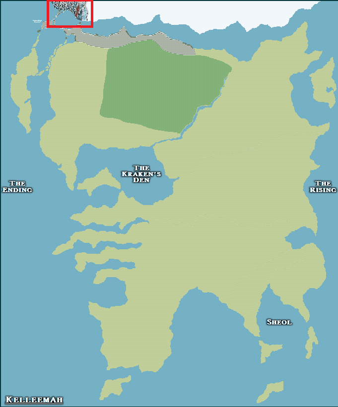
So far, I have only been showing the part of my world that I have done a lot of work on.
Some of my friends on social media have asked how much the maps that I have done so far fill up the world of Kelleemah.
So I decided to post on the forum the full continent map of Kelleemah.
This is a work in progress that still requires a LOT of work still - ha, ha!
The area that I have filled so far with the regional maps that I have uploaded on the forum is outlined in red.
I am still working through the placement of all the islands so there is a lot of work still going into that.
This is the fourth time that this game world has been re-envisioned since the 1980's and with each one the world evolves and grows.
As such, I have taken a break and have been going back over what I have done so far and I am tweaking it a little here and there and adding place names and such.
As always, I would love your input, although this is still a project that is still in its early stages.
Thanks,
Charles W. Robinson
Comments
I wonder, if you are putting that level of detail on this size map, will you see massive slowdowns in time? Plus, I know that there are a maximum number of nodes a map can have before CC3 crashes. I don't know if there is a maximum number of objects that it can handle as well. Honestly, I have no idea, but you might want to find out before you go too far with this. That's going to be a lot of symbols!
Very, very cool start to a large world map! Can't wait to see the progress!
I'm finishing up my first 'real' map. It has taken a long time but was a labor of love and a learning experience. I plan on posting a link in the near future here in the forums.
As for size/performance, a few numbers:
- Using CC3+ v3.66, Mike Shley overland symbols
- About 14,000 objects
- 75+ layers, most with sheet effects, quite a few with multiple effects, bitmap fills, etc.
- 1000mi x 800mi scale
With effects on a full redraw takes around 18 seconds. I have a 6-core AMD FX-6100 with 12G of mem and an ASUS ATI HD7850 with 2G of mem. I do have options set to minimize unnecessary redraws but also high quality for bitmaps, etc. I do work with effects off and often hide sheets while working both for speed and for ease in selecting objects.
I print tiled 3x3 with 2% overlap to produce 9 PNG files. This takes around 15+ minutes. Of course then I have to process/crop/assemble and align those 9 images and export to PNG ... and then post-process that a bit with Photoshop/GIMP/Paint.net. Painstaking process (at least for me, maybe I'm just slow) that takes 1 - 2 hours.
Resulting final file is a 15,600px X 14,600px PNG (around 330MB) that is about 26" by 25" when printed.
The map is so large I can't view it effectively on my monitor. And the monitor colors probably won't match the printed colors anyway. So printing it (at a place like OfficeDepot or the like) is an iterative process too.
Save often :-) Save your sheet effects as named presets too. Save custom palettes. Make backups (on another machine/drive or via email of FCW file :-) CC3+ has performed very, very well for me throughout this process notwithstanding the redraw/print times. Only a few crashes. Very pleased with it!!!
A long process but well worth it. I love CC3+ and have had a ball with it!
Best of luck,
-Mike
I am not sure on what the limits are.
I have thought of updating to a new computer with 32GB of Memory.
In addition, I can make several versions of the world map with each having a target region done.
Once I have the regions the way I want, I can then make a more general world map with the key terrain and locations on it.
Since I am reinventing the game world for the 4rth time, I am working from the micro to macro as opposed to the more traditional macro to micro.
I will essentially be using the basic world landmass and islands as a template so everything will match if I have to.
From what I have read, trying to cut out sections of a large world and create a new regional map is a real pain in the posterior. Ha, ha!
As an example, I may complete the region of Sutheimr and the surrounding regions and then save the file as Kelleemah Sutheimr.
I then go back to my template map of Kellleemah and remove the work from Sutheimr except near the border regions and then start on an adjacent region.
I can work my way through the regions this way.
I may go ahead and do a Concept Map for Kelleemah though that is more abstract, just to show people what it will generally look like.
But, I want the regional maps to eventually drive the overall look of Kelleemah.
As far as printing is concerned, I have noticed a big difference in how my maps look on screen and how they look when printed.
My printed versions look absolutely awesome compared to what I see on screen.
My original goal was to produce a world map that will just fit onto my gaming table in the garage (5'x8' for both roll playing & table top war gaming).
My test printing has produced great maps with excellent detail at this size & scale.
I may have to relook at this since there seems to be some limitations and make a more general overview map.
When I am starting to overload the program, what will be the symptoms that I will experience that will tell me that it is time to move onto another regional version of the map?
Thanks for all the advise! :-)
It could use a little more work, but things start going weird for the large continent when I try going beyond what I have.
Here, I have zoomed into the region around the Kraken's Den.
I placed a city at the scale that I am using now to give an idea of the size area I am showing.
The second one is zoomed in for the city and shows the level of fractilization compared to the scale.
There are a lot of islands planned to still go onto the overall map.
No computer crashes this way.