

Confused about contours and coastline

Hi,
I've never been great with CC3, and I'm just coming back to it after not using it for years. For the first time, I'm trying out working with maps I've imported from FT3.
I used the multiple-file export function in FT3 to export the entire world. In great detail…something like 10,000 maps.
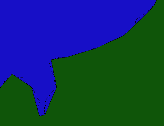
The problem is with the most zoomed-in maps. The coastlines are smooth (not fractal enough). I used the Fractalize command on the coastline and managed to get the coastline more jagged. Hooray. But now the outermost altitude contour doesn't fill all the all, or it goes past the coastline, obscuring the new, more jagged line. I've attached some images to show how things look now.
How can I get the contour to redraw, filling up to the new, jagged coast? I've tried the Edit Properties command, but can't get that to work. I also thought of deleting the contour and trying to make another, but I couldn't figure out how to do this and make it fill the landmass.
Help! Thanks!
I've never been great with CC3, and I'm just coming back to it after not using it for years. For the first time, I'm trying out working with maps I've imported from FT3.
I used the multiple-file export function in FT3 to export the entire world. In great detail…something like 10,000 maps.
The problem is with the most zoomed-in maps. The coastlines are smooth (not fractal enough). I used the Fractalize command on the coastline and managed to get the coastline more jagged. Hooray. But now the outermost altitude contour doesn't fill all the all, or it goes past the coastline, obscuring the new, more jagged line. I've attached some images to show how things look now.
How can I get the contour to redraw, filling up to the new, jagged coast? I've tried the Edit Properties command, but can't get that to work. I also thought of deleting the contour and trying to make another, but I couldn't figure out how to do this and make it fill the landmass.
Help! Thanks!
Comments
I managed to select the original coastline and then fractalize it more. Then I deleted the original, too smooth, contour. Then I went back to the now-more-wiggly coastline and used Edit Properties to do a solid fill of the original dark green color.
Looks great now. Now I can get to work.
Thanks for your help!