

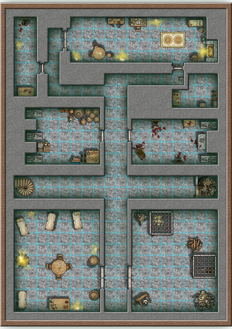
Basement battlemap with a printing challenge!

Gday everyone. I was stoked to see the Mike Schley symbol set converted to CC3+ so have been working on this smallish battlemap for our D&D group that, after an eternal delay is finally about to start some adventuring. If I have done it right it will scale properly to print onto A2 sized paper (will print 2 A3's and glue them together).
Have attached the FCW if anybody wants it.
EDIT: Having trouble attaching the FCW for some reason, I will try again tomorrow so watch this space.
EDIT2: FCW is now attached below the image.
As always, critique is welcome.
With effects on the grid lines are really thick but when you print/save they get dimmer and look a lot better, and not as imposing as in the attached image even (the resizing of the jpg made them a bit more dense than they are at normal resolution).
I'm really impressed with CC3+ much more reliable and faster than CC3. A fantastic upgrade.
And here is the challenge: Using this FCW, what is the highest quality you are able to either print as PDF (my preferred method) or save as jpg/png etc.
Here are my observations with printing to PDF with CC3+:
* The PDF printing with CC3+ is a lot quicker than CC3 which is awesome!!
* I could print upto 1200dpi fairly reliably with CC3 with some pretty big battlemaps (bigger than this one) but CC3+ can only go as high as 720dpi before it crashes on this map.
* I use PDF creator v2.1
I'm a bit of a quality hog so always want to print things at the highest resolution possible. So if anybody can get higher than 720dpi printing to PDF I would be very keen to know what software and settings you use!
Cheers
Mappy
Comments
JSM
"The printer (like most printers) prints bigger dots than the inter-dot
spacing.
The ink droplet covers a circle around 1/300 radius (or maybe a bit
larger - a lot will depend on paper absorbance).
The printer can place circle centres at 1/720 in the direction of paper
motion and 1/2880 in the direction of head motion.
So you get lots of overlapping circles on the paper. If you print at
1/360 circle centres X and Y, then the ink droplets would cover the paper
totally (no gaps would be shown).
However, the edges of droplets can be positionned at the centre
resolution - you can actually resolve details using this fact and it
certainly helps when you're putting down multiple droplets for colour
rendition.
All this apart, the position choices are not infinitely variable,
especially in the direction of paper motion. So if you want to print an
image at an effective 426dpi it will need to be resampled to something
that is based on the printer's actual capability. You can either use the
ordinary printer driver to do this (the default if you print from a
programme like Photoshop) or use superior algorithms in a programme like
QImage."
Yes, probably overkill on my expectations of resolution but I'm thinking about trying out some VTT software so if I can print the whole map as a really good quality PDF then save as JPG using Adobe Acrobat I can use the jpg on the VTT and zoom in really close to see all the nitty gritty details without pixelation.
CC3+ is awesome but a bit of a bummer if the print to PDF is not quite as good as CC3. Maybe it's just me or the PDF software I use, I have found PDF creator is better than Adobe Acrobat, but cannot currently get the 1200dpi that I could with CC3.
I've finally attached the FCW to the original post so it's there if anybody wants the map for themselves. Feel free to make any improvements and post the improved versions!
to balance your light dark problem to all lit.
Lastly I like it
D&D 5.0 Adventure?
To do that I used the line tool to make lines around the wall edges, then made each room area a different solid polygon (the fill was Solid 30) by selecting the lines that surround a room and using the “line to path” tool. This was all done on a sheet I called “Dark regions” and I placed this low in the list of sheets so it would be sitting “above” most of the symbols so they would appear dark too.
I put an “edge-fade inner” effect on the Dark regions sheet and at first glance it looks pretty good.
Have a better look though and some of the symbols on the SYMBOLS LOW sheet are affecting the dark regions, but if understand things correctly, they should not because they are on a different sheet and positioned so they are “under” the Dark regions sheet. But even weirder, only some of the symbols on the LOW sheet cause the effect. Have a look at the attached picture. Althought all these symbols are on the SYMBOLS LOW sheet, the piles of rubbish and boards have the edge fade effect around them which I don't want but the stairs and pouches look fine. The edge fade effect should only be occuring on the edges of the polygon, not the symbols.
[Image_4306]
Something weird going on or have I had a brain fade and am just missing something pretty simple?
I wanted to attach the FCW but I keep getting this message:
[Image_4307]
This method could have potential for me so would be great to know what’s up or what I am doing wrong. Probably tricky to solve without the FCW, any thoughts on why I cannot attach it? Some browser setting or something?? I've been able to attach FCW's in the past with no worries.
Cheers
Mike
As for the upload problem, this forum software checks the content-type of the file to make sure it matches the file type (To prevent abuse I presume), and for some reason, your browser tells the forum that this filetype is of type application/download, which is clearly not correct. I suggest either try a different browser, or simply adding it to a zip-file and upload that instead. Latter is not quite as convenient, but an acceptable workaround.
And thanks Monsen for putting your sleuthing hat on. Ok, I'm using Internet Explorer this time, fingers crossed for the FCW attachment. I renamed the troublesome sheet to "Dark regions" which is a bit more intuitive than "Shadow" and have corrected the above post to reflect that. In the FCW I have hidden all the sheets except Dark regions and SYMBOLS LOW.
A workaround here is to create a new sheet, place it somewhere between the SYMBOLS LOW and the Dark Regions sheets, fill it with a solid filled polygon (True solid, not one of these solid xx partial transparency fills) and applying a transparency effect to this sheet (Set opacity to 1%, 0 doesn't work). Just completely hide the sheet when editing the map without effects on, and turn it on for final rendering or if you work with effects on.
Wonderful map!
The Map looks great! What size is the full map when your done? Have you ever thought of printing them on vinyl or are these just one an done maps?
Thank you
SAbel
So most of the walled areas were created with those tools, but to create walls that could automatically cut away bits when I placed the doors, I just used the line tool with a line width of 1.0 as a multipoly does not allow the auto cutting of doorways. Make sure all the walls are also on the walls LAYER too, otherwise they won't cut.
For using these tools, I recommend checking out these awesome tutorials by Joachim de Ravenbel. They go into lots of great detail about using these tools and more.
As for the size of the map, I actually used it this weekend for our first D&D 5th edition adventure. I printed off a the top and bottom sections each at A3 size to be used as battlemaps. I just printed them on normal paper with the colour laser printer we have at work. Don't tell work though, I had to be sneaky.
I used the whole map on my laptop + 28 inch monitor running Maptools, a VTT program. Worked great as the map was revealed as the players wandered around so I only had to print the areas where there were going to be fights.
Cheers
Mappy
I couldn't print your map at 1200dpi using Adobe with the base fcw32.exe file, but after enabling LAA (details in the thread linked above) I was able to print at 1200dpi: Output PDF