Amazing work, Gandwarf. The sheer detail alone is inspiring (particularly Sirilion), but I am also blown away by your sense of design. Congratulations on what must have been enormous effort.
Question? What are the little green objects that you placed around the variously-colored patches of land? Are those shrubberies? Are they symbols or drawn objects?
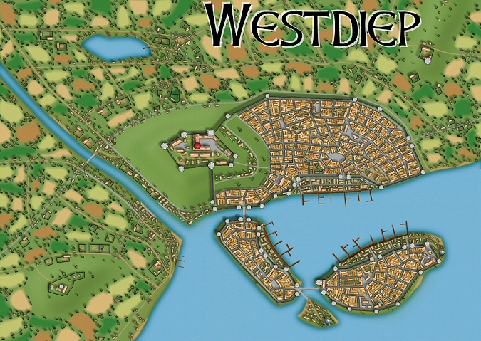
Dkarr: thanks! Zoutland was only 1 - 2 hours, Westdiep about 10 hours and Sirilion probably 20 hours. Sirilion was hard to finish as it was getting tedious after a while to place houses, farms, etc. That map kinda got me scared to do another big map :-)
I'd be particularly interested in tips on making densly packed buildings, like in Sirilion. I've achieved something similar, but only with hours of really, really painful cleanup around the intersections of streets, and I'd like to hope there's an easier way. Love the blur effect on the fields.
Iron Llama: I'll post some hints on that too. Placing houses will still take some time, especially if you have thousands of them like in Sirilion, but I didn't do any cleanup, so we must be doing something differently.
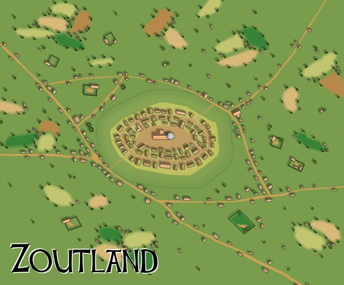
This is for Henrie61, some information on the Zoutland map.
I made a map with the CD3 Bitmap A style. Dimensions 1000x800 and background CD3A_Grass2 I used the standard effects you will get when you turn on the effects, only for the hill I made some changes.
Roads I made the roads with "All city drawing tools" and then picking Road, Dirt 5' smooth. You can just click around your map to start adding roads!
Fields All the fields were made with "All city drawing tools" and then picking "Terrain, fields". Again you can just click on the map to just create some different sized fields. I changed the background of the fields a couple of time to get different colored patches. I added hedge and bush symbols (part of the City Designer 3 package) along each field.
Houses The houses were made with the "House" tool. Most houses use "CD3A Thatch (No frills)" under the house settings. I also added some stone houses using "CD3A Classic (No frills)". The tower on the hill is a symbol that's part of the City Designer 3 package.
Hill - Click on "All city drawing tools" - Click on Advanced - Select "Terrain, fields" - Click on "New" - Name it something like "Terrain, hills" - Click on "Properties" - Edit the value under "Sheet" and name it something like "Hills" - Click "Ok" - Now create a hill - Click "Ok" again and create a hill using this tool and clicking on some points in your map. - After creating a hill you need some effects: click on "Sheets and effects" - Find your "Hills" sheet (or whatever you called it a few steps before) and click on it - Click the right most "Add" button and select "Bevel", enter 25, 10, 0, 0 - Click the right most "Add" button and select "Blur", enter 15 - Click the right most "Add" button and select "Wall shadow, directional", enter 1, 20, 6 and check "Use global sun direction" - Click the right most "Add" button and select "Inner glow", enter 10, 192, 192, 64, 255, 1 - Make sure that "Activate sheet effects" is checked and click on "Ok"
You should now have a hill like mine. This is just one way to do hills, I am sure there are better. In the Westdiep map you can see some different looking hills.
This is for Iron Llama, explaining how I did the denser buildings:
- First I created a system of roads using the standard road tools you can finder under All "city drawing tools". Roads always come first, it's like that in real life as well. I made sure there were empty areas for all the houses between the roads. It should look something like this:
X X X X X X X O X O O X X O X X X X X O X O O X X X X X X X
X = road O = housing
- Next I clicked on the "House" tool. I used the 8th house shape and the "CD3A Classic (no frills)" setting (see first screenshot).
- Now just start adding houses in different shapes and pack them really together (see second screenshot).
- You can add some more roads and start filling up the empty spaces with houses (see third screenshot).
- Now turn on the effects and zoom out a bit. You should have something looking like screenshot 4.
The trick is to do a large map so you can zoom out/resize. Because if you zoom in too much it won't look too good.
To get my maps I also added different styles of houses in each block, some gardens, some larger buildings, etc.
That actually looks more laborious than the method of drawing dense-packed buildings I've been using. After drawing the street grid, I use the random street tool to line all the blocks with buildings (that part goes fast), clean up the street intersections (because the random street tool puts buildings on top of cross streets), and fill in gaps thus created with the building tool.
Well, that's another way and the end result looks good too. That's what I like about Campaign Cartographer, you can get really different looking styles and maps. Personally, I like hand placing every single building, although it can get a bit tedious in the larger maps.
Why do not to put links with cards(maps) in size(format) fcw, that they can be useful in role playing game campaign. It would be very nice from your part.


")

Comments
Maybe one of my relatives will get this for me as a nice Christmas present.
Question? What are the little green objects that you placed around the variously-colored patches of land? Are those shrubberies? Are they symbols or drawn objects?
Again, great work.
Dogtag, the little green objects are hedges and shrubberies. They are standard symbols that come with City Designer 3.
Excellent work.
Since I am just in the first stages I am curious how you made thees. What settings did you use for Zoutland?
Dkarr: thanks! Zoutland was only 1 - 2 hours, Westdiep about 10 hours and Sirilion probably 20 hours.
Sirilion was hard to finish as it was getting tedious after a while to place houses, farms, etc. That map kinda got me scared to do another big map :-)
I made a map with the CD3 Bitmap A style. Dimensions 1000x800 and background CD3A_Grass2
I used the standard effects you will get when you turn on the effects, only for the hill I made some changes.
Roads
I made the roads with "All city drawing tools" and then picking Road, Dirt 5' smooth. You can just click around your map to start adding roads!
Fields
All the fields were made with "All city drawing tools" and then picking "Terrain, fields". Again you can just click on the map to just create some different sized fields. I changed the background of the fields a couple of time to get different colored patches. I added hedge and bush symbols (part of the City Designer 3 package) along each field.
Houses
The houses were made with the "House" tool. Most houses use "CD3A Thatch (No frills)" under the house settings. I also added some stone houses using "CD3A Classic (No frills)". The tower on the hill is a symbol that's part of the City Designer 3 package.
Hill
- Click on "All city drawing tools"
- Click on Advanced
- Select "Terrain, fields"
- Click on "New"
- Name it something like "Terrain, hills"
- Click on "Properties"
- Edit the value under "Sheet" and name it something like "Hills"
- Click "Ok"
- Now create a hill
- Click "Ok" again and create a hill using this tool and clicking on some points in your map.
- After creating a hill you need some effects: click on "Sheets and effects"
- Find your "Hills" sheet (or whatever you called it a few steps before) and click on it
- Click the right most "Add" button and select "Bevel", enter 25, 10, 0, 0
- Click the right most "Add" button and select "Blur", enter 15
- Click the right most "Add" button and select "Wall shadow, directional", enter 1, 20, 6 and check "Use global sun direction"
- Click the right most "Add" button and select "Inner glow", enter 10, 192, 192, 64, 255, 1
- Make sure that "Activate sheet effects" is checked and click on "Ok"
You should now have a hill like mine.
This is just one way to do hills, I am sure there are better. In the Westdiep map you can see some different looking hills.
- First I created a system of roads using the standard road tools you can finder under All "city drawing tools". Roads always come first, it's like that in real life as well.
I made sure there were empty areas for all the houses between the roads. It should look something like this:
X X X X X X
X O X O O X
X O X X X X
X O X O O X
X X X X X X
X = road
O = housing
- Next I clicked on the "House" tool. I used the 8th house shape and the "CD3A Classic (no frills)" setting (see first screenshot).
- Now just start adding houses in different shapes and pack them really together (see second screenshot).
- You can add some more roads and start filling up the empty spaces with houses (see third screenshot).
- Now turn on the effects and zoom out a bit. You should have something looking like screenshot 4.
The trick is to do a large map so you can zoom out/resize. Because if you zoom in too much it won't look too good.
To get my maps I also added different styles of houses in each block, some gardens, some larger buildings, etc.
Do you have any examples of your work?
The tips are greatly appriciated, will try them out as soon as I can find the time.
And considering the names of your towns and cities I suspect youre dutch. I am :-)