

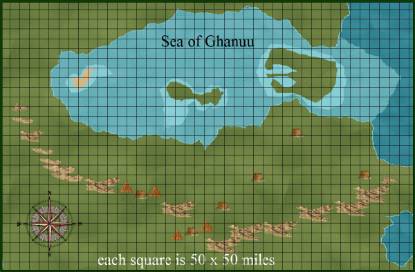
Sea of Ghanuu area, Crestar Using Alyssa Faden Overland
 JimP
🖼️ 280 images Departed Legend - Rest in Peace
JimP
🖼️ 280 images Departed Legend - Rest in Peace
Part of the Southern Hemisphere.
The lands that border it are: Trillolara, Land of Strife, Teslarc, Tanoria, Nomads, and the Inner Ocean.
There are three large islands: The Stopper, Isle of Fools, and Traql.
Legend has it that The Stopper can grow in size and block fleets, or even small ships, from entering this Sea.
No one seems to know that Traql is there.
The Barrier Hills separate part of Trillolara from The Plains of Dareth and part of the Nomads area.
The map is about 2100 miles wide x about 140 miles high.
The ocean area lower left is a mistake I'll correct in later versions.
The mountains, hills, and mesas are over-scaled. They do act as a barrier, and there are few passes across them.
Larger map here.
( Note that Jim is struggling with his computer... it appears to be winning, and then claims he hit the save changes button, not it. Sigh. Which is why I keep editing this post so mch...)
The large areas around the island maps were once land bridges.
Comments
Krini Forest is lighter as there are odd things going on there. Like Wild People and good wolves helping lost travellers. But watch out for the bad wolves, they are no help at all.
Updated on Nov 5, 2014
larger map here
Fondfield, a local military district headquarters, was the home to the player characters.
Quasqueton is where I ran B-1 module from TSR. The map and dungeon I have placed on this site is a new dungeon with the basic premise. It is South of Fondfield.
Sraa Keep is where the player characters encounter a tough dungeon, and a lich, it is west of Fondfield. Very little of Sraa Keep is on the surface. Oh, and watch out for the giant slugs !
Off this map:
The road leading off to the Northwest leads to the stone keep and grounds the player characters won. The road leads down the coast to Dwarfbas, the nearest Dwarven City. A few days away is Dwarf Home. A many level dungeon with many rooms.
Larger map 1200 x 1015 pixels
The two evil brothers in Land of Strife are vying for control. Tanoria and Teslarc are good areas. The Grey Fields is an ancient battle site. There be Ents in Teslarc.
The City-State is named for a small village, not the large seaport city. Legend has it that it was the first planned area in this city-state.
These City-States do mostly get along, but seldom have the capability to help each other in bad times.
a larger version of both maps on my web site.