

Fractal Terrains problems

First of all thankyou for your time helping me .
I just downloaded yesterday it and there isonly one version the version Ihave here is 3.0.12.0 FT3
1
I have used the RMF function to generate my world , but I got several strange rounded issues

I used 13 octaves, but after setting to 12 and it solved the issue . I noticed that if I leave at 13 and generate new worlds , I sometimes get the same issue and sometimes not ... something like a bug or something else?
I didn't notice from the top world large view the issue be4 untill when I went into a detail area to edit . though after when making attention I could see if the whole map had similar issue or not by the top view .
2
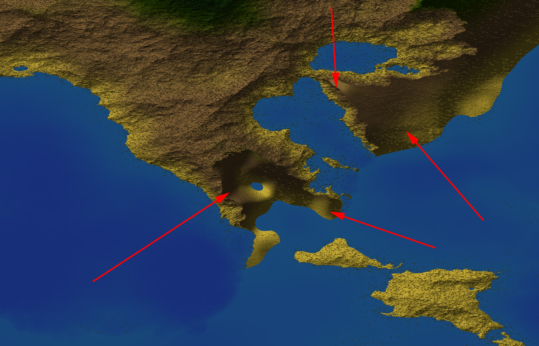
In this image the red arrows show the several editing I did . first of all I wanted to break the continent as was too huge for my taste and I lowered the land ... lower and rise seem to work but after some editing the land become to be rised smooth or lowered smooth ...
is there a way to lower and rise preserving or "recreating the roughness there ?
Is there a way to break a continent like by making also the continental platform around the coasts edited? As ypu see in the editing its just lowered land but no continental step .
The increase roughness and decrease roughness buttons to me do not work , they either create erratic results or dont work well , the lower one for example creates large bumps or mountains whatever the case .
Also whats The Value for ? When I select for example raise I can change the operation in the paintbrush options to lower or to value ... even if the button is rise, well rise and lower even on the same button work as written befoure but value seems to paint according to what he wants, I can't understand what it does well and how to use .
On some areas seems to paint on others nt and doesn't really works like a flattener on a specific value as I imagined

3
About the incise flow
Not sure how to use well as it gives a lot of interesting but also not really fine tuned results as I woud like , for example I would like ot control where and from where the river flow get incised in the map or to actually have a more natural erosion , without making rivers but also without lowering my mountains .
4
On some tutorials on FT I tried this
http://www.ridgenet.net/~jslayton/tutorials.pdf
and this
http://www.ridgenet.net/~jslayton/CGTutorial/index.html
I tried already both tutorials , the one in wilbur and the basic one for make world but my issue is I Can't edit the heightmaps in Photoshop and get them back in ...
also some tools do not seem to work well or perhaps not sure if I use them wirght because i can'tfind more tutorials apart the ones you already pointed me to and they do not help on do what I want to do .
For example if I get a world I am not satisfied with 100% and I want to add another continent I 'd like to save that map heightmap and then load a new generated world , pick a continent shape I like , export that heightmap , get both heioghtmaps in photoshop and combine as I want ... then rebring those into ft3 and apply some more effects ...
Would be cool to have some erosive filters just like the ones in world machine or a mod macro creation .
Any ideas on how I can import export normal bmps heightmaps?and bringthem back innormally ? I have to pass all time by Wilbur?
Because that tool as well when I reexport seems corrupted when I reimport in FT3 as shows only a gray image .
Is there a direct way to export a hieightmap out of FT , edit it in Photoshop and reimport in FT to continue work on it?
( Possibly without the wilbur middleware as apart from beeing unconfortable and slowing workflow , it produces a mdr file that is all gray and not showing anymore all other details that were befoure in the FT 3.
5
Also some tools do not seem to work precisely as in the "Help" guide ...
Here a test of the global set altitude value in a selected area ...

the settins are 500 feet but the results look pretty different than the ones showed in the help .
the same is happening with other global values in selections that usually cause stepped up and down surfaces without a natural look and hardly fixable after .
6
the strange artefacts all overe the terrain that I can't get rid of throught smoothing offset or roughness and don't see other smooth options
then the strage smoothed areas I get when I rise and lower terrain instead of retaining some of the detail roughness base from the terrain it smooths creating those strange hardlines borders ...
also Dunno how to get rid of those crest lines ridges , I tried even deterracing with no results,
the rise roughness or smooth roughness buttons seems to not work , actually the second rises the mountains .

7
On the Saving issues :
if I save as special mdr at 8192 x4096 it saves fine seems
If I save as wilbur mdr it says error saving whatever resolution I pick .
When I go to wilbur and open the special it gives error unspecified at opening the file unknown code ( -100000).
so what I have to do to be able to open in wilbur? in the tutorial says special mdr but it doesn't work for me .
Also if the resolution might be the problem if I go down I loose most of the details and the work done on it .
On another test a straight from heightmap PS map into Wilbur then saved as mdr . When opened in FT3 it gets all sort of weird results from flat blue map to grayscale maps without any other info .
I just downloaded yesterday it and there isonly one version the version Ihave here is 3.0.12.0 FT3
1
I have used the RMF function to generate my world , but I got several strange rounded issues

I used 13 octaves, but after setting to 12 and it solved the issue . I noticed that if I leave at 13 and generate new worlds , I sometimes get the same issue and sometimes not ... something like a bug or something else?
I didn't notice from the top world large view the issue be4 untill when I went into a detail area to edit . though after when making attention I could see if the whole map had similar issue or not by the top view .
2
In this image the red arrows show the several editing I did . first of all I wanted to break the continent as was too huge for my taste and I lowered the land ... lower and rise seem to work but after some editing the land become to be rised smooth or lowered smooth ...
is there a way to lower and rise preserving or "recreating the roughness there ?
Is there a way to break a continent like by making also the continental platform around the coasts edited? As ypu see in the editing its just lowered land but no continental step .
The increase roughness and decrease roughness buttons to me do not work , they either create erratic results or dont work well , the lower one for example creates large bumps or mountains whatever the case .
Also whats The Value for ? When I select for example raise I can change the operation in the paintbrush options to lower or to value ... even if the button is rise, well rise and lower even on the same button work as written befoure but value seems to paint according to what he wants, I can't understand what it does well and how to use .
On some areas seems to paint on others nt and doesn't really works like a flattener on a specific value as I imagined

3
About the incise flow
Not sure how to use well as it gives a lot of interesting but also not really fine tuned results as I woud like , for example I would like ot control where and from where the river flow get incised in the map or to actually have a more natural erosion , without making rivers but also without lowering my mountains .
4
On some tutorials on FT I tried this
http://www.ridgenet.net/~jslayton/tutorials.pdf
and this
http://www.ridgenet.net/~jslayton/CGTutorial/index.html
I tried already both tutorials , the one in wilbur and the basic one for make world but my issue is I Can't edit the heightmaps in Photoshop and get them back in ...
also some tools do not seem to work well or perhaps not sure if I use them wirght because i can'tfind more tutorials apart the ones you already pointed me to and they do not help on do what I want to do .
For example if I get a world I am not satisfied with 100% and I want to add another continent I 'd like to save that map heightmap and then load a new generated world , pick a continent shape I like , export that heightmap , get both heioghtmaps in photoshop and combine as I want ... then rebring those into ft3 and apply some more effects ...
Would be cool to have some erosive filters just like the ones in world machine or a mod macro creation .
Any ideas on how I can import export normal bmps heightmaps?and bringthem back innormally ? I have to pass all time by Wilbur?
Because that tool as well when I reexport seems corrupted when I reimport in FT3 as shows only a gray image .
Is there a direct way to export a hieightmap out of FT , edit it in Photoshop and reimport in FT to continue work on it?
( Possibly without the wilbur middleware as apart from beeing unconfortable and slowing workflow , it produces a mdr file that is all gray and not showing anymore all other details that were befoure in the FT 3.
5
Also some tools do not seem to work precisely as in the "Help" guide ...
Here a test of the global set altitude value in a selected area ...

the settins are 500 feet but the results look pretty different than the ones showed in the help .
the same is happening with other global values in selections that usually cause stepped up and down surfaces without a natural look and hardly fixable after .
6
the strange artefacts all overe the terrain that I can't get rid of throught smoothing offset or roughness and don't see other smooth options
then the strage smoothed areas I get when I rise and lower terrain instead of retaining some of the detail roughness base from the terrain it smooths creating those strange hardlines borders ...
also Dunno how to get rid of those crest lines ridges , I tried even deterracing with no results,
the rise roughness or smooth roughness buttons seems to not work , actually the second rises the mountains .
7
On the Saving issues :
if I save as special mdr at 8192 x4096 it saves fine seems
If I save as wilbur mdr it says error saving whatever resolution I pick .
When I go to wilbur and open the special it gives error unspecified at opening the file unknown code ( -100000).
so what I have to do to be able to open in wilbur? in the tutorial says special mdr but it doesn't work for me .
Also if the resolution might be the problem if I go down I loose most of the details and the work done on it .
On another test a straight from heightmap PS map into Wilbur then saved as mdr . When opened in FT3 it gets all sort of weird results from flat blue map to grayscale maps without any other info .