

Jan Challenge WIP Island Map - Finished :)

[EDIT]
Finished")
Entry in competition thread
[/EDIT]
Hi.
I am currently working on an Island map for the January 2014 challenge thread (assuming I can get it finished for March 1st).
I was wondering if someone could provide me with advice as to how I connect the river with my coastline? It looks fine when I'm working with sheet effects off, but as soon as I turn them on to see how the finished map will render, the river and coast REALLY don't work together.
What should I do to connect the two and make them look good when sheet effects are turned on?
Finished
Entry in competition thread
[/EDIT]
Hi.
I am currently working on an Island map for the January 2014 challenge thread (assuming I can get it finished for March 1st).
I was wondering if someone could provide me with advice as to how I connect the river with my coastline? It looks fine when I'm working with sheet effects off, but as soon as I turn them on to see how the finished map will render, the river and coast REALLY don't work together.
What should I do to connect the two and make them look good when sheet effects are turned on?
Comments
Did you try using the modifiers - snaps the cursor to significant points on an entity (like a coastline). They are the lowest six buttons on the right side of the screen (at least, on my setup). The one you want is the diagonal blue line with a red circle about a quarter of the way up.
Joe Sweeney does a YouTube on adding rivers. It's on the ProFantasy site under Community/Tutorials/Overland Mapping & General.../part 6 or F - Adding Rivers for a quick review or here:
Good luck in the contest.
By the way - would you share where you found all of those excellent ships? I'm doing a port city. Also looking for ship wrecks.
Thanks,
Miri
If the land glow is changed to inside, the glow around the river banks show into the water, and if the land glow is set to outside (like now) the sand shows after the end of the river.
The maps I made when I was following Gandwarf's tutorial didn't have this problem, so I think that the problem is due to the fact that my Sea and river are on different layers. I made this map with the sea as the background, and with CD3 city maps (including the ones made using gandwarf's tutorial) that's not usually the case.
Only way I could change things at this point to make sea and rivers on the same layer, would be to find a way to create a fill that (in art program terms) would be an inverted version of the current land layer. I havn't got a clue if that's possible, and if it is how I might do it.
Maybe it'll be easier to just photoshop the ends of the rivers after the map is done.
To answer your question, ships are from the CSUAC, I made all the trees on my map myself, and everything else so far is either from default installs of CD3 or DD3
Of course that will rob you of the darker edge of the river - I would recommend drawing a little darker outline on the city background underneath the river. If you create a new sheet for that, you can also apply a Blur or Edge Fade Inner effect to integrate it more nicely into the background.
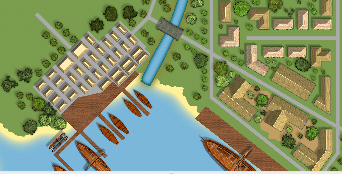
I was a little worried about the darker outline ending up with the same problems once it gets to the coats boundary, so thought I'd experiment with some small dikes instead. I've added it to the first section of rive up to the bridge as a tester.
I also repositioned my river end slightly (and amended the road network to compensate), added a drop shadow to the docks (and then altered the sun position so the shadows still worked) and added a bit of a widening polygon to the end of the river to get rid of very straight cut offs into the beach.
Do you guys think that this looks better?
My first attempt was to save the map as a PNG with no anti-aliasing and at 1 foot to 1 pixel. That's pretty close to the resolution of the images in this thread which seem to be about 3 pixels for every 4 feet. I put 15840 x 15840 in the max box and the process crashed pretty quickly. I decided to try saving this time at 1/3 of the resolution 5280x5280px and tried with 25% anti-aliasing. This has now been running for about 30-40 mins, CC3 says it's 'Not Responding' but it's fluctuating between 650-800MB of RAM and is using a constant 50% of my CPU that doesn't really fluctuate much. It certainly seems to be doing 'something', but the status of the app as far as windows is concerned is `Not Responding` and it still stays "Rendering Pass 1/15 please wait" after 30-40 mins.
I don't really know if I should just leave it going for as many minutes or hours as it needs, or whether I need to save in a specific way to get a large file. Is there a good tutorial somewhere that details the best way to make very high resolution exports?
Here is your map using the second version of the image as base for the resize.
You misunderstand. I'm not just saving a small area, I'm printing off a HUGE map and am just posting a small chunk of it in this thread. I'm just using the same chunk as before for context. I would post the whole map, but it's huge and doesn't show the issues I'm seeing unless you zoom in to a small area like I'm doing.
The actual image that the last little 450x287px snippet came from is 5280x5280px in size (3 feet on the city map is 1 pixel on the image). I can't save the map at 1px to 1 foot, simply because CC3 crashes when I try, so I'm gradually working my way up.
I've now got a 7040x7040px map saved, and the same snippet from that one (left of attached image) is 598x433px. The problem is still there though. My tree symbols look great (pretty much identical to how they look in app), as does the land, coast, rivers, dikes and ships. But the roofs and the docks look awful.
The export is nothing like the versions you see on screen in CC3 when you render the effects. You can see the difference with this example. The left is an exported JPG at 100% quality the right is print screen from the app.
Is the "exported" side of the image at zoom factor 1:1 in your image viewer? If not, can you post a detail of a single house at 1:1 zoom from your exported jpeg file? I believe it should looks fine.
Just to explain myself I've made a quick map, and exported a jpeg in a similar way you do. I'm not sure I used the same symbols you use in you map, and scale factors are surely different.
Below you see my samples aligned like the one in your previous post (only road and houses on my map).
If you refer to the noise on the roofs (these black blobs are less evident on my map), this is a simple artifact due the extreme rescale of the image needed for it to fit the screen.
If you zoom the image (the exported jpeg), you'll see the roof the same way as you see in the DETAIL box of my image. It seems you are using symbols with roof-tiles on top of them, so is natural to see such noise.
I think the same problem is for the texture image of the docks.
I can't upload the full map here as it is far too large, so I'll link you to it instead. I didn't include the full map before simply because the majority of it is unfinished and therefore not really ready to show.
But if it will make things clearer here is a link to the biggest JPG I have been currently able to save : Griffendon_try2.JPG
To get around this when exporting, go to View>Display Speed Settings and set the Fixed Bitmap Quality to Very High. You will have to re-set this every time you restart CC3.
Yes, IMO the problem can be from the large scale of the map, and the relatively small size of the symbols, but I can't say for sure, since I've never used such a combination.
Did you try adding a little blur effect on the houses sheet?
To achieve a larger export resolutions maybe you can try with the PdfCreator method, as explained here.
Fingers crossed Shessar's suggestion works, if I understood right then it sort of makes sense from a technical perspective. I'm very glad I tried saving now though, this would have been very annoying had I left it to the last minute, and missed the competition deadline.
Your other problem may be that you are exporting in the .jpg format. JPEGs are a lossy format. That is, they exclude some of the images definition in order to make the file size smaller and exclude even more when resizing in paint type software. PNGs are lossless and give the best resolution when exporting and also when resizing.
However, if I force the use of low res to sort out the fill textures, the symbols (e.g. my trees) don't look as nice as they did in previous saves. They still look pretty good, and I could live with this level of detail, but they looked slightly better in previous saves.
Is there a way to just force low res textures for the fills, and keep the default textures (which is was picking higher resolution) for the symbols? I can see that in display speed settings I can modify something related to fill style resolutions, but I'm not really sure whether I could use this to achieve the goal of forcing CC3 to use LOW fills and VH symbols, or not.
I'm pretty happy with how my first map is turning out, and have learned a hell of a lot. Putting down individual trees takes AGES but I think it's ends up looking pretty good and I'm glad I spent the time first making a large symbol set of custom trees.
I've got to get in finished up tomorrow, so thought I'd post a link to a high res copy now, and ask if anyone has any recommendations for layer effects that would make it better.
Currently there is the main walled port, a logging village in the north, a load of farmland mixed between crops and livestock to the west of the main settlement, a small 'rich' area with private docks just north of the city and a small lookout on one of the islands. I'm considering more trees and farmland in the unfinished areas.
http://www.theten.co.uk/Griffendon_75percent.PNG
Excuse the roof fill quality, I was testing out medium to see if it would work better than low. I'll stick with low for the final image
http://forum.profantasy.com/comments.php?DiscussionID=4206&page=1#Comment_29414