

Chūhan: Northeastern Píngyuán Valley (CA81 DeRust Style)
Here is a small regional map for an area my players are in right now. I'm satisfied, if not exactly happy, with it. To be honest, despite owning most of the PF catalogue for... probably close to 15 years +/- , I haven't done much mapping (there never seems to be any time). I've played around a bit, followed some tutorials and made some small test maps, but very few actual campaign/adventure maps, I'm sorry to say. I'm trying to remedy that, and I'd appreciate any comments or criticism folks can offer.
One thing I can say right away is that, after I clipped this section from a much larger [unfinished], world map, I tried to fractalize the coast. But CC3 kept giving me some weird combination of 3 lines rather than simply fractalizing, so I left the coast a little rougher than I prefer. Also, I only labeled three of the locations/towns because, frankly, those are the only places the PCs know about right now and I'm hoping to subtly — or not-so-subtly — keep them focused on the adventure, rather than on adventuring.
To give the map some role-playing context, for those interested, it depicts the northeastern end of the Píngyuán River Valley, in Chūhan (my campaign world's China proxy). It's actually winter right now but the map doesn't depict the snow or other seasonal changes. The PCs have been hopping the disk (my world is flat) looking for the pieces to the Rod of Seven Parts. They're currently in the lumber town of SongQiang, preparing to journey to the Ruins of Okabaimura*. Okabaimura was a city built centuries earlier by invaders from Hanashū, the island nation making a small cameo in the NE corner of the map.
Cheers, and thanks for any comments or suggestions,
~Dogtag
(Click the image for a high-resolution version)
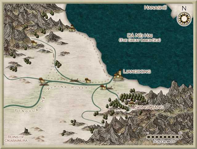
* Okabaimura is the starting point for the adventure, The Palace of Plenty by Tito Leati, appearing in Dungeon magazine issue 130. I've adapted the adventure as the first half of this leg of the party's quest (for the 3rd part of the Rod). I have no pride or shame when it comes to incorporating or adapting existing materials into my campaign world.
One thing I can say right away is that, after I clipped this section from a much larger [unfinished], world map, I tried to fractalize the coast. But CC3 kept giving me some weird combination of 3 lines rather than simply fractalizing, so I left the coast a little rougher than I prefer. Also, I only labeled three of the locations/towns because, frankly, those are the only places the PCs know about right now and I'm hoping to subtly — or not-so-subtly — keep them focused on the adventure, rather than on adventuring.
To give the map some role-playing context, for those interested, it depicts the northeastern end of the Píngyuán River Valley, in Chūhan (my campaign world's China proxy). It's actually winter right now but the map doesn't depict the snow or other seasonal changes. The PCs have been hopping the disk (my world is flat) looking for the pieces to the Rod of Seven Parts. They're currently in the lumber town of SongQiang, preparing to journey to the Ruins of Okabaimura*. Okabaimura was a city built centuries earlier by invaders from Hanashū, the island nation making a small cameo in the NE corner of the map.
Cheers, and thanks for any comments or suggestions,
~Dogtag
(Click the image for a high-resolution version)
* Okabaimura is the starting point for the adventure, The Palace of Plenty by Tito Leati, appearing in Dungeon magazine issue 130. I've adapted the adventure as the first half of this leg of the party's quest (for the 3rd part of the Rod). I have no pride or shame when it comes to incorporating or adapting existing materials into my campaign world.
Comments
The only thing I would change if it were mine is the point where the westernmost tributary joins the Plains River.
At the moment it joins to make a long straight line that is a bit jarring, so it might be worth seeing how it looks
if you make the join before the bridge rather than after it. But it's a minor point really.
Thanks for sharing!
Peter
I would consider making the coast line smooth or more fractalized, especially the Hanashù piece.
The only thing that I see are the mountains behind the SongQiang label, they overlap the other mountains below them (the ones close to the scale bar). And the rivers could be a bit more curvy IMO.
I quite like the land area or your map, but I'm not so fond of the sea. I think that a more cartoon-styled see, such as the one shown in http://forum.profantasy.com/comments.php?DiscussionID=4007&page=1 would really improve the map.
On small details, I'm a little disturbed by the mountains that overlaps the sea, and the change of width in the rivers is a great effect, except at the exact place the change happens. Maybe you could hide this place behind a symbol in some cases?
I would love to see a river tool where you could specify a smooth change of river width.
@Fub
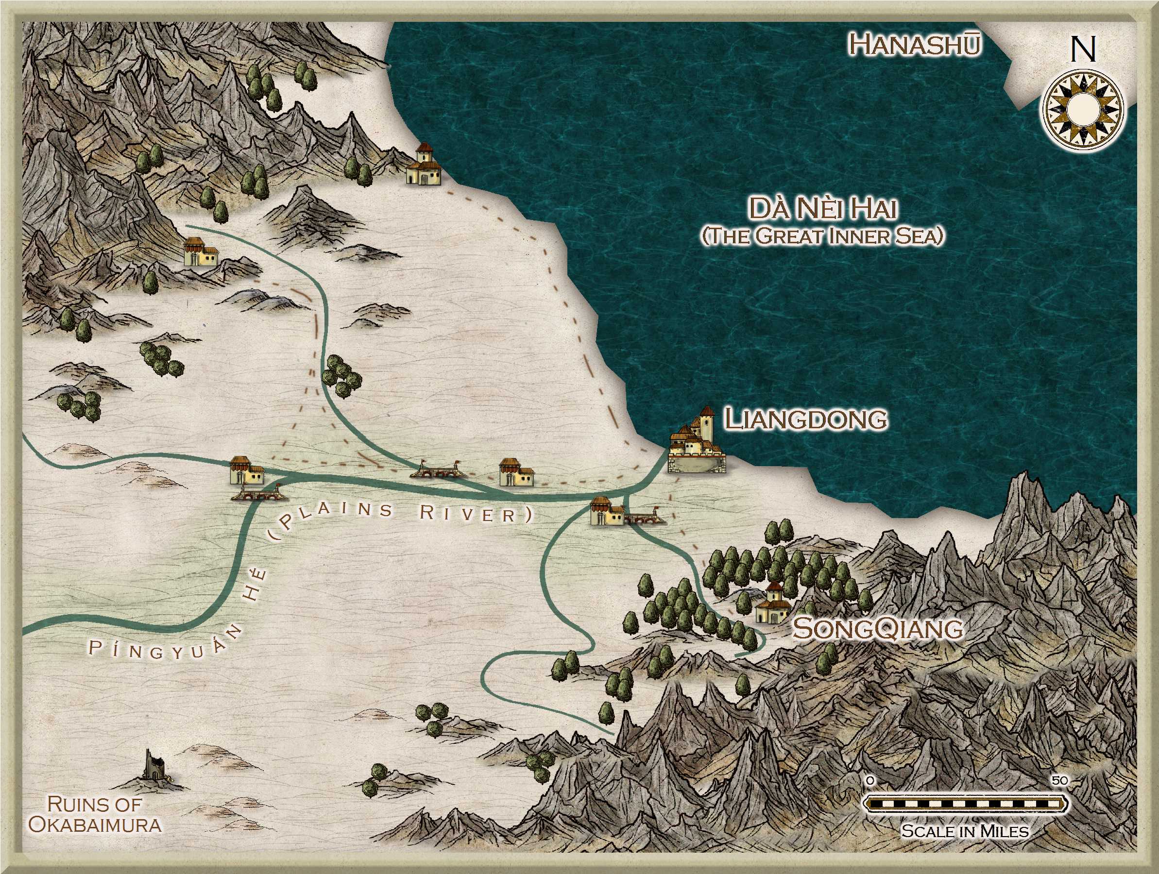
One thing I wasn't happy with was the coastline. I wanted to fractalize it but when I tried, I got some very odd results. I was pressed for time to get the map done so I left it as a casualty. A few other things niggled at me too, such as the roads. However, I was satisfied overall and the map served its purpose for our game session. But I do want to tweak it, simply to improve it and to get some more practice.
@PDJ
I intentionally made the Plains River less curvy here because it's a very long river that is much curvier near its source and the valley here kind of levels out. However, now that you pointed out that unusually-straight section, I'll address it in an upcoming revision. Thanks.
@JDR
Thank you for the encouragement and praise. The coastlines really irked me and I spent more time than I should have trying to fractalize them. It was getting late here (around 1-2 a.m.) so I accepted them as they were in order to finish the map. After an all-too-short sleep, however, I realized I could have simply replaced the fractal part with a completely redrawn one after I exploded everything. I've never exploded or combined things before (except once, following Joe Sweeney's dungeon tutorial), so that solution hadn't occurred to me in my late-night stupor. Remember, I haven't actually made many finished maps; fewer than half a dozen, I'd guess. Anyhow, in my latest iteration below, that's exactly what I did. I think it's an improvement, though I'm sure I'll get better the more I practice.
@Leviathus
Spot on about the mountains! Sheesh, sleepless mapping is bad for geography.
@JimP
Yeah, I started DMing around 1980.
@Gathar
Everything on the map is part of the mapping style, but I don't disagree about the sea. There's a lighter sea within the mapping style but I didn't care for the color, for this map. I may experiment later to see if I can find something a little lighter.
Again, many thanks so far,
~Dogtag
Here is the updated version so far. As before, click the map for a higher resolution version.
Consider also making the text glow a little bit transparent. Especially on the very dark sea.
Now, adding a transparent effect to the text sheet will make the text itself also transparent so here is how I would do it :
1. Add the transparent effect to the text sheet. Experiment with the opacity % but the default 50% might just do it.
2. Create a new Text2 sheet with no effect.
3. Copy all the text to this sheet.
This way you have text entities on the first sheet only there to generate the transparent glow and copies on the second sheet unaffected by the transparency.
Only a suggestion, of course. The map is already cool as is
Thanks again for the continuing feedback and tips.
~Dogtag
(Click the image for a high-resolution version)
Only thing I would change is to hide the origin of the rivers behind the mountains.
But that is a personal preference.
http://www.profantasy.com/annual/2013/september13.html
http://www.profantasy.com/annual/2013/special13.html
Note that, right now, only the 2016 and 2015 annuals work with CC3+, but the dwarves in the ProFantasy forge are working on conversions for the previous annuals as well. They are a small company, though so it'll take a little time for them to get everything caught up.
Cheers,
~Dogtag
At the end of the year, PF wraps up all the issues for that year into a single installation file. I typically download and install it just to be sure I have any updates that were made throughout the year (which happens occasionally, if someone reports a bug or something). it also installs a PDF overview of that year's issues, like the one on the ProFantasy site.
Historically, annuals have also been available for purchase on a physical disc. I can't remember if you pay for it up front or if it's only available for past annuals. Regardless, it won't ship until every issue has been published for the year, natch.
Personally, I've found every single issue useful, even if it's for a type of map I don't typically use. That's because there's almost always something to use in the issue, or some new tip or trick. The only downside I've encountered to subscribing is finding a new favorite style only to later find another!
Annuals are available for purchase as whole-years only. There is currently no per-issue purchase plan in place and I don't know if ProFantasy is even exploring that at the moment, seeing as they're so busy with a ton of other stuff.
Anyway, I hope that answers your question.
Cheers,
~Dogtag
On your product registration & download page you use to have an option to buy a disk of annual you had bought. Ralf or someone from support usually can help out if you bought an Annual or other products a download, but want to get a disk of it latter on.
You can modify fractal lines with the Fractalise button
Does that help at all? I can't tell because I'm really sleepy and just started rattling things off. If I'm unclear let me know and I'll try again once I've had some sleep.
Cheers,
~Dogtag