

Help with Starting a City
 anomiecoalition
Traveler
anomiecoalition
Traveler
I'd like to map out a relatively large city (about 10,000 residents) for a series of adventures in my Al-Qadim campaign. Unfortunately, I'm really awful with cities/villages/towns, etc. I think the biggest problem for me is scale. Buildings are easy since you can work off a 5' grid and get a sense of the rough size things should be...but I have no idea how to begin to map a city. So, I thought I would ask some of you guys if you have any pointers about setting the initial size of the map, working with or without a grid (and if so, what size seems to work best), working with the layout, etc.
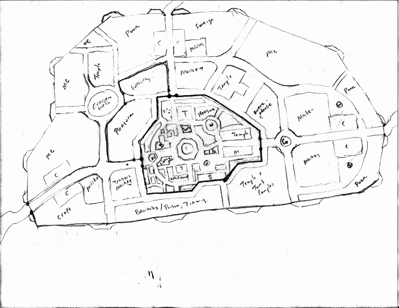
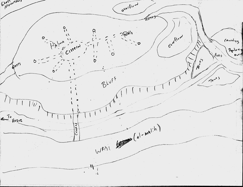
Here's a sketch of the city and its environs. Its loosely based of an official Al-Qadim city. Built on a Bluff overlooking a wadi (temporary river), it serves as an important center for trade in the region. It will have a number of temples and wells (all linked together by an underground complex of cisterns and tunnels - I look forward to mapping that out eventually). There will be an old city (walled in) and a newer city (main wall) along with a great deal of temporary tent villages outside (occupied by regional nomads)
So yeah, any pointers are appreciated.
*Edit...Eventually the whole thing will be sort of detailed like the old city, but for now, I just wanted to layout the wards...each would presumably have wells, inns, baracks, etc. C = Caravanserai (caravan complex with stables, shops, inns, etc.) MC = middle class type areas
Comments
When I draw the town itself in CD3 I always start with the land like rivers, seas, marking out hills etc. After that I draw the towns city wall, if it has one and add the roads that will lead to and from the town. When that is done I continue by drawing all the important places in town, like palaces, temples, docks etc. I then draw all the roads to and from those places, this will be the main roads in the city. When I do this I also try to logically decide where to put in major squares, usually where two main roads connect/split. When you've come this far you will have a town that is divided in empty squares by the main roads and important places. I now take one square at a time and finish it, this will make it easier to finish a large town, dividing the task wont make it feel as an overwhelming task to complete the city.
Just some small notes, I hope they help.
For 10.000 inhabitants I'd go with 2' standard roads 4' important streets and 9' for the 2/3 most important roads on a standard size map.
You would require +/- 1000 houses/buildings for that amount of inhabitants.
I guess the biggest fear I had was that I started a map at the standard 1000 x 800 scale dimensions and worried that at some point I would wish that it was much larger. So, I think before moving forward I'll experiment with a few sizes to get a feel for what will work best. To that end, the Source Maps add-on sounds like it would be a good resource...And Moskva's insights on scale sizes will also be helpful.
So my sense is that you guys largely eye-ball sizes and scales (i.e. no grid)...so, eye-balling my doodles, would you say that a decent starting size would be closer to 2000 x 1600 or like 4000 x 3200?
- SteveDavies' Mapping Cities Tutorials (awesome, loads of detail and ideas)
- Clercon's Making a City Tutorials (great stuff)
- Gandwarf's CD3 PDF Tutorials (tips from a master)
Hope those help (they're really good, did I mention that).Part 1: Location, Location, Location
Part 2: Urban Planning
Part 3: Laying Out Districts
Part 4: Districts in CC3
Part 5: Sizing Buildings
Part 6: Filling Blocks in CC3
Part 7: Houses Galore!
Part 8: Outside the Gate
Part 1
Part 2
Part 3
Part 4
CD3_Tutorials.zip
~Dogtag
Make a background story before I start planning the map. This goes for almost all my maps, not just cities.
Make a global design. Sometimes on paper. More often just in my head.
Make a first CC3 drawing to lay out the landscape (I usually forget something important and then later have to go back and fix it.
Draw in the most important land features. Mountains, river, hills, ect, you get the point.
Draw in the walls and/or the main roads.
Go from there.
And then there is one more thing I do. Usualy before going to sleep I take a peek and the map.
This way my brain can keep working on it while I go to sleep.
Strange maybe, but it does work for me.