

Maps for my planned novel

Hello all,
currently I write a novel and want to make maps of the world, the regions and important towns. Some maps are planned to be as B/W-versions in the book, but I also want to start a HP with an interactive tour for it. So I got CC3, CD3, SS1 and the Annuals 2007-2010 and I`m ready to go.
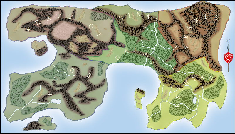
After some small tests I got started with the world map (Annual Fantasy World Style), which is my first map to showcase here and which surely still offers some room for improvements.
Please tell me your thoughts and what you would improve in order to get a better map.
I`ll explain the colors for a better understanding of the borders:
Purple: Orcs
Blue and Yellow: Human Kingdoms
Green: Elves
Black: Dark Elves
Red: Dwarves
currently I write a novel and want to make maps of the world, the regions and important towns. Some maps are planned to be as B/W-versions in the book, but I also want to start a HP with an interactive tour for it. So I got CC3, CD3, SS1 and the Annuals 2007-2010 and I`m ready to go.
After some small tests I got started with the world map (Annual Fantasy World Style), which is my first map to showcase here and which surely still offers some room for improvements.
Please tell me your thoughts and what you would improve in order to get a better map.
I`ll explain the colors for a better understanding of the borders:
Purple: Orcs
Blue and Yellow: Human Kingdoms
Green: Elves
Black: Dark Elves
Red: Dwarves
Comments
I`ve made some small changes in displaying the names for Isos and Sinas, but there will surely be more in the near futurem so I won`t render it again at the moment.
I`m currently revising the shape of the map. Then I`ll try it again and this time with less mountains and more rivers for a more realsitic look
It's just a thought for your consideration. The map looks like a great starting point.
Steve
A good point about the different coastlines, I`ll definitaly consider that. Thank you!
I`ve tried some different placements and I`ve quickly visualized my current favorite. The rivers will also get more Deltas, it`s just for the overview:
+ There are two basic mountain chains dividing the land and being natural borders
+ The human kingdoms are placed in the plains. Some hills, forests and lakes are there
+ The dessert is caused because there are the mountains on the right and it is surrounded by (foot)hills, which prevent the rivers reaching the inner region. A perfect placement for tough guys like the Orcs
+ On the upper right side of the chain, there is either a swamp or barren lands (what fits more in your oppinion?) There is a river as natural border to the forest section. If it`ll be a swamp, than there can the dark elves be found here, else the dwarves and more mountains.
+ The forest in the middle will have many river deltas and the "normal" elves
+ On the right side of the second chain, there should be a barren land. Maybe I`ll get rid of the barren land on the left side and replace it with more forests or foothills. There should be the highest peaks and also maybe some tough guys living in the snowy high regions.
+ The other islands aren`t really spectacular at this stage. At the moment I just want to have a volcanic island in the upper right region. The islands will be done afterwards.
Due I used the fractal-tool I can`t get rid of some nodes, but it should still be possible to smooth some coasts up manually. I`m thinking of a region near the dessert or barren lands, for a classic sandy beach
What do you think? Would a vegetation like that be belivable? Of course that`s all fantasy in the end, but still there are some rules made by the the nature itself
I think that looks good, in my opinion the swamp is very fitting. My grandpa has some beach property and it's sorta swampy. I don't know if you wanted ideas like this, but if you want to make the swamp extra interesting (and even terrifying, if that's the effect you want) you could have some carnivorous plants that maybe the elves are cooperating with. Real carnivorous plants live in swampy areas so that would be sort of fitting if you like the idea! Just a suggestion though.
Keep up the good work!
hmmm - interesting idea.
But those winds should be dropping TONS of water on the southeast part of the continent, especially when they hit that eastern mountain range. So I'd expect to see a lot of vegetation over there (forest, jungle etc.) Plains seems a little unlikely.
Beyond that, without knowing where the continent is (equator, 45 degrees north, 60 degrees south) it's hard to make other comments about the climate zones.
Steve
Oh, it looks like one of the rivers in the middle of the land runs from the ocean in the north, past mountains, then to the ocean in the south. That's a no-no. Rivers start where there is enough water and flow downhill. If they start at the sea, there is nowhere lower to flow to.
I`ve rearranged the mountain chain for a better placement of the desert. I think I`ll place the chain more upwards near the swamp to get a bigger desert. It will not immediately start as a desert though, I want a barren scrubland slowly becoming a desert.
The continent should be north of the equator and have a warm climate (snow permanently only on the peaks or very high regions)
Are the mountains and the rivers placed well, or should there be more or less?
I have some real-world comments below. Take them with a grain of salt. If you want your rivers 'just the way they are', that's fine. Just be aware that there are some things that would be unusual in the real world, so it would be a good idea to have an explanation of some sort for them.
Mountains: I don't have as much insight into where these should be placed. Having said that, your continent as a whole doesn't have a similar earth equivalent, so I'm looking at it in piece-parts. The semi-circular mountains in the middle remind me somewhat of the alps, which I believe formed when the Italian peninsula slammed into Europe. These ones look pretty eroded by now. You have a few north-south 'peninsulas' of land, which could (but don't have to) have mountain ranges running down them.
Rivers: Rivers flow from high to low, so overall the flows are ok for that. More often you'll see them flow to an inlet on the coast (because rivers tend to erode the ground under them). One of the rivers in the south-east does this nicely (stars in a mountain, runs to a nearby bay). Some of the rivers run down the middle of a peninsula, then dump into the sea at the end. This can happen (see the Mississippi in the US, the Nile to a lesser extent, or other rivers in Asia) but it's less common, and usually happens when a river has a lot of sediment and deposits it as a delta). In a couple of places your river skirts a bay or nearby coastline and travels further before it dumps into the sea. This could happen -- there could be a small mountain range, or hard rock. But it looks unusual (I'm looking primarily at the southern river in the South-East, but there is a smaller one that does something similar in the north).
Again, you can probably come up with an explanation if you need to. But if you're spending your time explaining to someone why the map looks the way it does, you're taking their focus from the story (unless the story is about the oddities of the land).
Steve
Thank you very much for the detailed information! I`ll try to get the rivers more realistic, due focusing on the story seems better to me
I am also thinking of creating a lake in the lower North/East-section, let`s see how this develops.