

Another First CC3 Map
 Sheelon
Newcomer
Sheelon
Newcomer
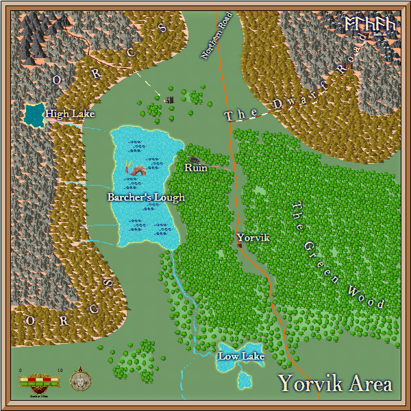
Here's my very first map (after about 100 revisions of this n that!). It's a 100 sq mile wilderness map with a broad swathe of very rough terrain in the North West inhabited by (as per the map..) Orcs!
Things I would do differently if doing it again:
1. Less mountains and more spaced out trees. I think I crammed too much in there and it's not *quite* the effect I wanted. Put in three tiers of contour lines and wanted them marked with different styles of mountain as I went - but I'd definitely reduce their number by at least 50% and space them out a lot more.
2. More watercourses - possibly - whilst CC3 is used to scale a certain size of map, I dont think it should go all the way down to "babbling brook" level.
Comments
You already pointed out several of the possible inprovements yourself, and I agree with your assessment.
I would try to illustrate the precence of Orcs differently. Right now, it looks like e regular map label, indicating the name of the place. Maybe use a bit more describtive text, like "Here be Orcs!", or replace it with a symbol.
The yellow glow along your lakes also look strange. It makes them look like they have sandy beaches all around them. Unless they really have this, I would drop that glow, or at least select a different color.
The rivers leading into the lake from the west also looks a little bit to "heading straight east". Perhaps change the direction a little bit, and maybe make at least one of them wind a bit more.
Also, the water seems to be running down from Barcher's Lough and down into Low Lake, but water doesn't run from this lake?
Suggestion:
What strikes me is the rivers from the mountains. Those flowing from the mountains are quite straight.
Rivers tend to fall into 3 stages, Upper, Middle and Lower rivers. Upper rivers (those that start in mountains) tend to be small, lots of tributaries running into it, fast, rough and slightly winding with lots of rapids. Middle Rivers are often very wide, winding with random-looking turns, curves and occasional rapids. They often form ox-bow lakes especially on flatlands. Lower Rivers are broad, fat, much more straight, with gentler curves, that lead to the oceans.
The river flowing from Barcher's Lough is perfect for a Middle Stage river.
I say this because I've noticed with a lot of overland maps, that this single concideration (the stages of rivers) goes a LONG way in making a nice looking map. I put a lot of thought into the river before placing anything else as that will have an effect on the rest of the map. Mountains, hills and vegetation are all going to be affected by the route of the river.
Look forward to seeing more maps from you!