

FTPro - First map - Boralis; Feedback welcome

This is my first attempt at a real detailed map in FT. I've had the original version for years and years, and just upgraded to the Pro, and am playing with all the new features. I've tweaked the colors to try and represent real-world a bit better.
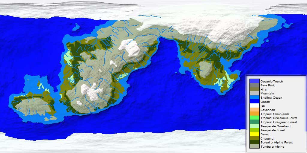
Boralis is a cold world, much of it under ice and glaciers. Civilization exists mostly along the coasts. Think of it as an entire world of Vikings.")
I have a couple of questions based on my experiences working on this, if anyone can give me pointers or advice
1) There were quite a few areas within the main continent that went below the water level. Selecting them all by hand and lowering the water level for each of them was a bit time-consuming. Are there any shortcuts for selecting these areas so the Fill Basin action will catch them?
1a) After the Basins have been filled, they are almost perfectly flat, and any rivers that cross them invariably turn into perfectly straight lines, and often have multiple rivers running perfectly parallel across them. Is there a good way of roughing these spots up so rivers behave a bit more realistically?
2) Climate: Especially in a world like this one, seasons are a very important part of the climate model. Is there any way of telling what 'season' it is in the default map, or of tweaking the settings to simulate the different seasons, so that the summer and winter extremes could be compared? That way you get a better idea where the most livable parts of the world were and place the largest cities there.
Thanks!
Boralis is a cold world, much of it under ice and glaciers. Civilization exists mostly along the coasts. Think of it as an entire world of Vikings.
I have a couple of questions based on my experiences working on this, if anyone can give me pointers or advice
1) There were quite a few areas within the main continent that went below the water level. Selecting them all by hand and lowering the water level for each of them was a bit time-consuming. Are there any shortcuts for selecting these areas so the Fill Basin action will catch them?
1a) After the Basins have been filled, they are almost perfectly flat, and any rivers that cross them invariably turn into perfectly straight lines, and often have multiple rivers running perfectly parallel across them. Is there a good way of roughing these spots up so rivers behave a bit more realistically?
2) Climate: Especially in a world like this one, seasons are a very important part of the climate model. Is there any way of telling what 'season' it is in the default map, or of tweaking the settings to simulate the different seasons, so that the summer and winter extremes could be compared? That way you get a better idea where the most livable parts of the world were and place the largest cities there.
Thanks!
Comments
Also, regarding the Basin fills, I haven't tested it yet, but I think if you globally set the water level to -1000 (or wherever your break between shallow and deepwater ocean is), run the Basin Fill app, then re-set the water level back to 0, it ought to take care of it. Perhaps a quick and small global roughening will take care of the flat basin syndrome as well.
The climates in FT are computed as the average of the four points on the orbit relative to the axial tilt (a "summer", "winter", and two "fallspring"). There isn't a way to get the system to show you any particular "season". Flipping the axial tilt will make things change, but probably not quite what you were hoping.
For roughening, make sure that you use Tools>>Global Noise>>Land Offset rather than Tools>>Global Raise>>Land Roughness. The noise tool adds a random noise pattern to the surface; the raise land roughness tool merely scales the underlying fractal function. The noise will affect river paths; raising land roughness will not affect river paths.