

Can't figure out the best approach for this style of map

Need some help!
I'm working off of 30-yr old maps that used a particular style for indicating mountains: simple ridgelines. I'm really struggling with the best approach to putting mountains on the map. These are close up maps where hex = 9 miles. So there are LOTS of mountains on some of the maps (there are 70 8.5x11 "tiles" that make up the whole "world"). On one map, I am ending up with 200+ mountain symbols (which slows the rendering to an abysmal crawl - sometimes crashing the app).
Plus, lots of forested area. I cannot figure out the best approach to placing forest area. ESPECIALLY forests that surround mountain areas. It doesn't look quite right.
I've created the maps in CorelDraw as simple "google-style" drawings. I'm attaching a crop of one of the maps where there are lots of ridgelines. The white areas are "alpine" snow covered peaks. There are ravines/canyons at the bottom of the cropped area. I can't find good canyon symbols to represent that either.
How would you guys approach recreating this map in CC3? I'm all ears!
Comments
Same with the forests. Draw a polygon of a green color, and then place a few tree symbols to show the tree type for that area.
Still - any and all ideas on solving this large problem are welcome!
- in CC3/System/Drawtools/ copy an existing overland style folder and rename it to your new style
- start a map from the matching style and in File > Drawing Properties change the style to the new one.
- Go through the sheets one by one and either delete them if you don't need them for your style, or adjust the relevant drawing tools (Advanced button) to create the entities (rivers, ridge lines, etc.) you need. don't hesitate to experiment and create lots of new tools.
- Add new sheets where you need them.
- Adjust/add sheet effects. Edge Fade, and Edge Fade Inner would work well for your canyon and alpine areas respectively.
- I'd do forests as dark green polys on a sheet with a transparency sheet effect (say 50% or so).
I'm requesting a refund as I've burned about a week of days wrestling with numerous installs/uninstalls/crashes, etc.
I can create basic maps with CorelDraw and Photoshop. I was just hoping CC3 and DD3 would be perfect and quicker. But the issues prevent any real success other than anything I can create very quickly.
I also have some of the symbol catalogs that are missing images (regardless of how I install). I suspect there are missing links or something. Linda has mentioned that they can fix those. I need to get her the names of the catalogs.
Maybe I'll give this one last shot - but that will put me past the 14 day guarantee... ugh!
Here's the overall map (hex = 9 miles). Every symbol and ridge line has an impact on the players' movement in-game.
Lots of detail. I need to go back in and add the locales, roads, regional naming, etc. I'll just do that in Photoshop.
Any tips or constructive feedback is welcome. I'm learning a lot as I go!
The only thing that looks odd is the change of river color. Is that intentionnal or are the darker ones part of the (great) hand draw thing ?
If that the case, you should be able to cover the dark one with a spline on the river sheet and a lot of clicks...
Fantastic maps !
I think you've done a good job.
Some (idiosyncratic) comments:
* The mountains look a little too random. Typically (but not always) mountains run in ridges and lines - - here I don't get a sense of their structure. On a more practical level, it's tough to understand where passes might be (which is probably something you'd want to be able to tell from the map)
* Stylistically, and especially on this scale of map, I want the Mountain symbols a little bigger -- through most of history they were significant barriers, and I think they should loom bigger. I'd also try (not sure about this) making the tree symbols smaller, or go to a texture. There's not a lot of information in the forest parts of hte map, so I'd make them less prominent.
* I love the cliffs (where are those symbols from, I don't remember them). I'd like the bottom of the canyons to be slightly different -- have a mild texture to it, or slightly different color. What I really want is for the river-side of the cliff faces to blend a little more. Right now they look a bit like they were plopped in.
* The paths of the rivers are a little unusual--not impossible, but unusual. I'm mainly looking at the right-hand river that apparently loops around the full mountain range, while one interior river flows to the upper right and one next to it flows to the lower left. It's possible, but implies that there is no overall tilt to the land.
I look forward to more show and tell. This map is outstanding.
Steve
The two colors for water are: light blue = slow/shallow water, dark blue = fast/deep water.
I appreciate the input a lot. The one thing you should bear in mind - these maps were drawn by my friends about 30 years ago. They had no sense of actual geologic reality... thus the fairly random feel to things. In the pencil version of the maps, every ridge line has a direct impact on what can or cannot move through the hex (or it takes a full day to "cross" the ridge).
Also... the campaign world is FLAT as a pancake. Not spherical. The mountains are the only real major landscape other than the foothills and ravines. So things are a little "different" than a traditional spherically based map.
That's been the biggest challenge of the whole thing: how to represent those ridgelines in a new style and have the same movement restrictions. I'm not sure I've hit the right balance yet. I agree on the forest texture size. I just used symbol clusters for this version. It should be simple enough to utilize a texture - but I do want a dimensional feel to the forest areas.
Map of the month??? Ummm... sure!
- Draw a second rectangle further out, so that it is encompasses everything you have drawn.
- Set the drawing properties to Color White, Fill Style Solid, Layer MAP BORDER
- Be sure to be on the topmost (lowest in the list) sheet in your list
- Do Multipoly on the two rectangles.
The resulting multipoly should be covering everything beyond your border.
Hope that helps.
To hide the edges, especially if you have sheet effects showing through, I genereally use white filled polygons. Another option is the decorative border.
Edit: Arghh Ralf, you got me here!
- They get their on sheet and layer, so that they don't mess up the map border: Both are called SCREEN. The SCREEN SHEET goes below the MAP BORDER sheet in the sheet order.
- Properties are Color White (15) and Fill Style "Solid".
- I then draw one polygon around the map border, clicking points as shown below. This keep the object count low, and I don't have to worry about multipolies.
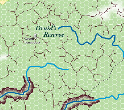
The area is known as the "Sylvanian Forest" and almost everything is covered in something green. Other areas of the world will have more common mountain-ish coloration. The yellow path is an old "hidden" elven path. On the top left is a dwarven red-brick road.
Here we go...
So glad you stuck with CC3! I know I could learn a lot from you.
Steve
Thanks gang!
For bitmap fills, you need to edit the scale of the fill style the tool uses. Just click on the fill style indicator in the top statusbar, bitmap files tab, find the fill yuo wish to change, then make sure the checkbox for scaled is checked, an enter appropriate dimensions. If you wish to also use the original scale in your map, you can just make a copy of the existing style in a new name, then make a copy of the drawing tool that used this style, and change the fill your new drawing tool uses to your new scaled fill.
Thanks to everyone for the assistance and tips.