

How do you make HUGE maps?

Hi, I'm playing around with my new CC3, and have a question about huge maps. I will attach 3 files to make my problem more visable.
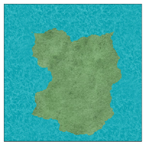
My problem is that the bigger the map is, the worse the "resolution" will become. In particular, I am tyring to draw land masses, and the random coastline will just become a straight line with bigger maps.
Attached are 3 files: one 60x60 mile land mass with a 100x100 map resolution, one 60x60 mile land mass with a 1000x1000 map resolution, and one 60x60 mile land mass with a 10000x10000 map resolution. This later is almost a square.
I would like to draw land masses that are like on the 100x100 map, but I would like to make my map big.
Is there a way to do this, other than draw small parts of the map, and paste them together?
Thanks,
Ati
Comments
The land mass is always the same size! 60x60 miles.
To change this, you can edit the drawing tool.
Right Click on the "Deafault Landmass" button, click "Advanced >>", select the "Land, default" in the list, hit "Options", and change the fractal settings. Just unchecking "Values are percent of the map border" will do the trick. Be aware that windows places some limitations here, so drawing very large shapes with high fractalization can cause problems.
Also note that to place more than one attachment in a single post, all you have to do is post it, then edit it, and you can add another attachment. Reapet, and you have 3 attachment in one post.
This is going to be awesome!
Thanks for the quick response!
Good luck with your map. Just a word of caution, since we are talking about details here. Be carefull that you do not add too much details to huge maps. That has several downside, including the map looking messy when zoomed out, and that the map becomes slow to work with due to the amount of nodes in it (and even crash-prone if you overdo it). It is generally better to create more detailed maps for the relevant region of the map (a local map), rather than go for full detail on the world-scale map. You can easily copy entities from a larger map, and then apply fractalization to the forms to add detail when you create the local map.