Contour Shapes Not Blending Into Eachother

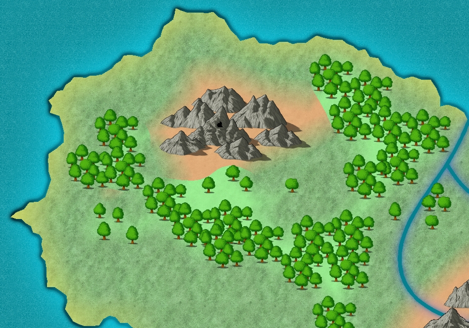
I've been able to make some progress with my first map, but now I find myself stuck again. When I put contour shapes in behind the mountains and forests, they blend nicely into the land but not into each other, as you can see in the picture. I've tried to figure it out to myself to no avail. Can anyone figure out what I'm doing wrong this time...? <:S

Comments

  • JimPJimP 🖼️ 280 images Cartographer
    edited November 2009
    Here is how I did it. I placed the forest and farmland polys first. Then the mountain poly of color. Then the symbols on top of that. What I go for on the polys is a wavy edge. I might even fractalize them one click. To adjust the poly so it covers the area i want again, in case the fractalize moves it too much, I use the Node Edit on the left side of CC3 to grab and move the poly edge. If i fractalize too much, it can be tedious to move the edge of the poly. Insert Node and Delete Node come in handy as well.
    02g.PNG 288.6K
  • I think your moutain and forest shapes are on the same sheet.
    Sheet effects apply on the whole sheet but not on every entity on the sheet. It means that all the shapes on the same sheet are considered as a single entity.
    A lot of sheet effects, like edge fade, glow, bevel... affect the global edges so if you draw, say, a circle and draw a small circle inside the first, the second one won't be affected at all (or marginally at the best).

    I don't know if I'm clear enough, but to make it short, draw your shapes on two different sheets.

    Also consider that sometimes effects are a bit deaf to the Apply Sheet Effect command, especially when you show hidden sheets or add entities. Don't hesitate to activate them twice ou thrice in a row...
  • Posted By: Joachim de Ravenbel
    I think your moutain and forest shapes are on the same sheet.
    Sheet effects apply on the whole sheet but not on every entity on the sheet. It means that all the shapes on the same sheet are considered as a single entity.
    A lot of sheet effects, like edge fade, glow, bevel... affect the global edges so if you draw, say, a circle and draw a small circle inside the first, the second one won't be affected at all (or marginally at the best).
    Hooray! That did it! :D Thank you, Joachim!

    Thanks for your advice too, JimP, but I'm afraid I couldn't make out much of it because I'm so new at this. <;) I don't get a lot of the terminology you're using. Learning this program reminds me of what it was like to learn Adobe Photoshop in a foreign language when I was in my early teens! Ha ha.
  • JimPJimP 🖼️ 280 images Cartographer
    edited November 2009
    By poly I mean I draw polygons. I have a template I created, it is on my web site, that has bitmap fills for different elevations and land types.

    On the left side of CC3 are 3 buttons with the names I gave above. I used them to move the outside edge of the polygons I draw, to better fit what I want it to look like.

    The Fractalize is a button on the left side of CC3 you can use to roughen the edge of a polygon so it looks more like terrain instead of a blob of color.

    If that is still confusing, it will become clear with time as you learn the program. This program does have a steep learning curve. The tutorials are a good thing to go through.
  • Posted By: JimPBy poly I mean I draw polygons. I have a template I created, it is on my web site, that has bitmap fills for different elevations and land types.

    On the left side of CC3 are 3 buttons with the names I gave above. I used them to move the outside edge of the polygons I draw, to better fit what I want it to look like.

    The Fractalize is a button on the left side of CC3 you can use to roughen the edge of a polygon so it looks more like terrain instead of a blob of color.

    If that is still confusing, it will become clear with time as you learn the program. This program does have a steep learning curve. The tutorials are a good thing to go through.
    Thank you. It does seem rather difficult and I don't think I could manage without the tutorials and the kind help of the people in this forum. I'm sure I'll learn a lot from everyone here. ;)
  • I was lost to. But after 10 years of work I have a web site with over 1,800 maps on it. Oh, uhm, many of the surface maps are open ocean... I am uncertain how many have land masses on them.

    Sigh. I found some link glitches on my Crestar site, working through finding and fixing all of them.
Sign In or Register to comment.