

[WIP] Community Atlas - Artemisia - Dworaguz region
![[Deleted User]](https://secure.gravatar.com/avatar/c75d9a245b74d9c59be0999ea81ca541/?default=https%3A%2F%2Fvanillicon.com%2F92add7f8c954488718110edc4896ad39_200.png&rating=g&size=200)
I have decided to do a regional map just to keep me from going insane with my city maps (only 4 left in the pipeline).
I gave also decided to make this a WIP which I have never done before, with the possible exception on the city of Dun Fingolfin.
So I will post progress reports daily, just to see how I go.
First up, the region to map.
I gave also decided to make this a WIP which I have never done before, with the possible exception on the city of Dun Fingolfin.
So I will post progress reports daily, just to see how I go.
First up, the region to map.
Comments
Added forest trees (more to come); Structure names, according to Statrippe map which this one overlaps a little; Fixed rivers so the don'y run over hill peaks.
To do: Tidy up forests, name a few natural features, add more small rivers, add some more points of interest.
I wonder if it is ok to reroute some of those rivers just a wee tiny bit?
I'm looking at the one north of a ruined tower or castle that seems to run along contours around the hills rather than in the valleys.
Added a few points of interest - a waterfall thundering down into a gorge (and underground river), a sulphurous geyser region, dwarven gates to dwarven halls, for a start.
Fixed the forest and rivers more to my liking - taking notice of sue's comment above.
Added cartouches.
Any further critiques warmly welcome. It may be ready for the Atlas tomorrow. I forgot how simple and quick regional maps are vis-a-vis cities LOL
I'm glad to see that you managed to resolve the rivers. They look a lot better
I get what you mean about the forest, and will clear a few more areas - perhaps a few with limber hamlets.
Also. perhaps a burrow or two (for the wight Rabbits).
The only way a forest would be completely contiguous is if the world had no humans and no natural disasters.
Maybe their from the CSUAC?
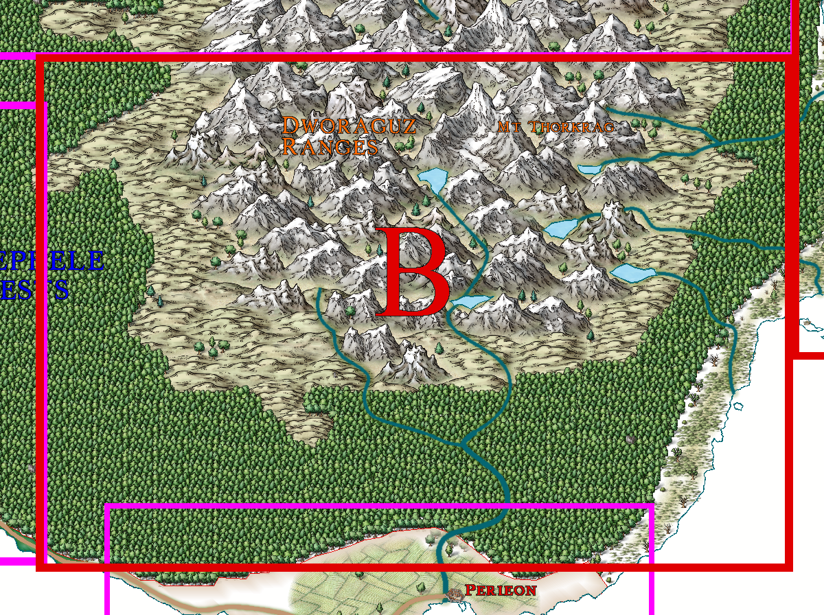
Dworaguz Ranges
The whole region is dominated by the majestic heights of Mount Thorkrag with its four crystal clear lakes at its base. Here are also two of the gates to the once sprawling dwarven Realm of Thordabrok, now sadly diminished into a few dwarven enclaves and largely peopled by other more hostile subterranean races.
To the south of the mountain is a sulphurous geyser region, home to a yellow Dragon; to the west are the cliffs, thunderous waterfalls and chasm of the Gates of Morthel, leading down to a grim Underdark, and its haunted barrows of a long-lost people. East in the hill country is an Orc village and tribal regions. They pose no danger except to a foolhardy adventurer or other orcs.
Several ruins are to be found – Fort Kinoxos, a ruined defensive structure manned by humans and dwarves alike in happier times. Now, alas, it is the lair of very nasty creatures. In a similar situation can be found the crumbling stones of Elsinora Keep, another joint Dwarf-Human collaboration.
Another ruin, Castle Dionsa, was once a proud stronghold of the former Kingdom of Statrippe, now a mere Archduchy. It was laid waste by wars with its neighbour, now the Kalliochos republic. It was these wars which much diminished both realms, Statrippe becoming an Arch-Duchy, while Kalliochines overthrew their King, and declared a Republic based on freedom and equality of all (especially for those at the helm of the republic). The brooding Legephele Forests soon reclaimed much of the former realms, which are now confined to thin coastal stretches.
To the east of the overgrown castle are four enchanted faery rings of a significant size – up to 20 miles in diameter -the Nimphodel Faery Rings. They are covered with a fine moss-like grass not seen elsewhere in Artemisia, or perhaps all Nibirum. Adventurers have reported that every midsummer Eve, the Faery Folk ride on their steeds, and party on till dawn. There has been talk of changelings in the cities to the south and west, but nothing is known for certain.
North is a great but hidden danger to the whole of south-east Artemisia. For here, in a ‘cottage’ festooned with giant sweets and lollipops, is the formidable Ogre-Witch of the Sweet Sickness. Her latest victims were the adventurers, Hansel and Gretel, who were seeking to survey Castle Dionsa with a view to restoring it. The Witch amputated all their limbs, and fed upon them, while the poor wretches died. Their heroic father, heir to the Archduchy, recovered their limbless bodies while the witch was away, and buried them nearby. Their graves remain green and unscarred, protected by the faery folk; even the witch cannot pierce the protective magic – and after a few futile attempts, she has desisted, concentrating on her plans to manufacture an organism which will cause much death and suffering to humanity – her ‘Crowning Venom’ with 19 deadly components – she has only two to obtain.
Just to the east of the Faery Rings are the Darken Caves, reputedly full of forgotten dwarven treasure (as if dwarves would forget treasure!) and certainly full of the decomposing bodies and bones of foolhardy treasure seekers.
The northern Statrippe town of Tendarl (pop~4700) is now a frontier town, with ruins of two villages, Forsted and Verstalt undisturbed since the last wars. A small mining town, Duthilig, is north of Tendarl and its tributary village of Geldwater. Here some iron and copper is mined, though the region is increasingly hazardous to the growing concern of the Archduke.
Varelt, to the west of Tendarl, is somewhat larger (pop 5300) and still receives valuable lumbar from the crimson barked trees, Corymbia rufus, which are a termite resistant hardwood much sort after by builders. The land between these two towns is fertile and heavily farmed. At the edges of the forest is the famed Kendaros Cairn, raised in honour of the region’s greatest hero, who, with his small band of men, held off an invading orc army for 2 days till the main force from Pereion (the capital of Statrippe) arrived. The orcs utterly perished, along with Kendaros and his Brave 100.
There is also a large series of stone henges – the Petroshenge. There are at least 20 circles, the largest being almost a mile in diameter. Why they are there, and for what reason, and who built them remains a mystery.
The final ruin is the more recent ruin of Heralisne Citadel, due to abandonment because of the increasing infertility of the soil, and recurrent droughts that has turned this region into little more than an unwelcoming scrubland – with dangerous sinkholes and quicksand, especially near the citadel and its small attached village, now also abandoned. And to make matters even more unpleasant is the mangrove coast, host to many biting insects, poisonous water snakes and vile pustular-skinned toads – Cain’s Toads. The whole of this scrubland was abandoned over thirty=five years ago, leaving dilapidated hamlets to bake in the sun.
In all, a region once filled with the glories of civilization, now gradually slipping into the mists of time.