

My First World Albion

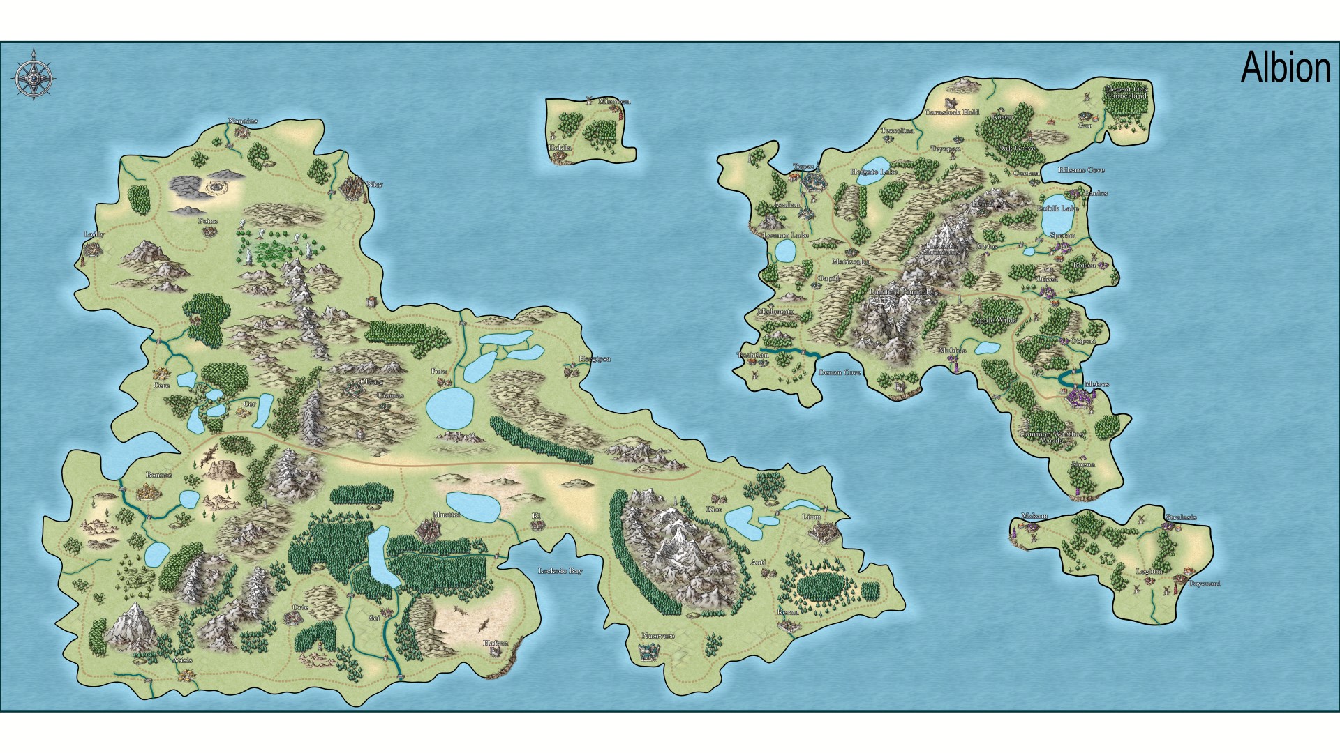
Over the past year, and more like 3-4 weeks of actually using the software, I started creating my own world. It's rough right now but I want to improve it. I like the general idea of the map but I think I need to start concentrating on finer details that really make the world feel real.
I hope I can get some positive and constructive feedback from everyone. I uploaded a low res version as well as a link to my hi resolution files. I hope you will enjoy watching me take this journey as I improve my world!
Onedrive link to maps
I hope I can get some positive and constructive feedback from everyone. I uploaded a low res version as well as a link to my hi resolution files. I hope you will enjoy watching me take this journey as I improve my world!
Onedrive link to maps
Comments
The mountains are looking good, though I'm finding it a bit strange to see them separated from the foothills the way that they are on the eastern continent. Unless there is a good reason for that gap I recommend closing it up.
The forests could do with a few more single trees to break up those very hard edges in places, but other than that a fine job.
Maybe add a deep water contour to give the ocean a bit more interest?
Also good idea on the deep water! I'll take a look into that I've never done it before.
I did a blog a little while back about adding contours to oceans here, if that helps:
Shore and ocean effects for overland maps - part 2
The style I used in that blog was Herwin Wielink, which has 3 different ocean textures. I don't think the Mike Schley style does, but it has ocean contour drawing tools, which add polygons of transparent shade.
Sue I followed your blog regarding shore and ocean effects and I'm having artifacting while I have my background on. I'm getting white spots or white dots in the new Background sheets I made. I attached a picture to show what's going on.
Try changing the texture in those areas to "Solid 20 bitmap" and using a blend mode sheet effect set to Multiply. I would increase the EFI there too so that the edge is not so sharp.
I made dark outlines in the water for the deep areas. Created more rivers where I thought they were appropriate. Removed trees between hills and mountains where they didn't seem to fit. Smoothed out some forest areas so the edges weren't so hard. Other minor changes.
You can see a large gap between the mountain and hills I'll need to close that up. Otherwise I'm liking the progress.
Looks great other than just that strange optical illusion
My desktop is filled with unorganized pictures lol. What does everyone think about my newest version? Biggest improvement is fleshing out the land by adding more features, smoothing out the forest edges, gave it some beaches etc.
So here's where I need specific feedback. I'm starting to smooth out the rough edges in my map. I think I've done a good job so far as a once over. Honestly I think I need to start reading about how to make maps. I think what I have I could pass off as reasonable to my D&D group but I always want to get better.
I do have one question I have. I'm using the Overland Mike Schley symbol set. If I use one of the Custom drawing tools such as Terrain Default, Woodlands Pine, how can I change the density of the trees? For example if I want the trees to be more dense, is there a way to edit the tool to double the density at which the trees are drawn?
Thanks everyone for the help so far!
I'm not an expert with drawing tools, so you will need help from others on top of my advice for the details of 'how to' here, but as I understand it the woods drawing tools use a symbol fill that is a saved 'Symbols in Area' setup. You can make your own Symbols in Area setup by opening the dialog from the Draw menu. There are several options there, but I think the one you want is Symbols in Area.
Two major changes I've made is how the forests are laid out. One side of the mountain range will be more densely populated as compared to the opposite side of the mountain range. Second minor change is reworking of some of the rivers/wetlands to make them flow more natural. Trying to carve out a singular high/low point, and have the rivers join together instead of fork.